Wednesday, August 22, 2012

Savanna Biotopes in Kundelungu

In my last BLOG entitled: FORESTS BIOTOPES IN KUNDELUNGU I said there would be more posts to illustrate the key Biotopes that help define the Landscape Ecology  of the High Katanga Plateau in Kundelungu and Upemba National Parks (see more HERE).   Now, to the fourth post which focuses on the SAVANNA biotopes.

D. SAVANNA BIOTOPES IN KUNDELUNGU:

As mentioned in an earlier BLOG entitled:  Landscape Ecology of DAMBOS in Kundelungu--we noted that much more is explained by topography and altitude than latitude or longitude in the vegetation sub-types that we see.  

Recall also that we use three ALTITUDE ZONES OF INTEREST to better organize and explain what is seen:

a) > 1500 meters (cool/cold where more humid savannas and forests are found)

b) 1000 >1500 meters (the mid-plateau valleys/hills with drier forests and savannas and more fire)

c) < 1000 Meters (and the lower valleys and basins where larger lakes, rivers, and wetlands dominate).


Recall also the LAND CLASSES defined by the  Royal Museum for Central Africa in Tervuren Belgium in their Carte d’Occupation du Sol (see the small version of the map below and a larger PDF MAP HERE).  

They only recognize THREE CLASSES using the FAO methodology known as the LCCS (Land Cover Classification System.   As mentioned earlier that system works fine on a global scale if the primary goal is to define vegetation types by STRUCTURE which is useful for forestry and agriculture applications, e.g. computing biomass or production potentials.  Their savanna categories are:

1) Wooded/Tree Savanna

2) Bush/Shrub Savanna

3) Grassland (Herbaceous) Savanna


But, these three categories leave out some of the Biotopes that we feel are important for ecological monitoring and research focused on what the park will need to manage and protect.  We feel that the FIVE LAND CLASSES defined by ecologists/biodiversity experts (below) is more useful (see website--Biodiversité végétale du Katanga).   Following is an explanation of the sub-types they recognize and select photos to illustrate them.  Whether the distinctions are worth separating out is a judgement park officials will need to make.

a) Riparian/Alluvial Woodland Savanna

This landscape can be found in many areas of the ZONE ANNEX of KUNDELUNGU for example in old CUT-OFF MEANDERS with deep alluvial soils.  The dominant tree species  are the thorn-trees such as Acacia and others such as: Combretum and Terminalia usually found on brown, clayey silty alluvial soils.  The ground layer is dominated by tall grasses, lianas, and often mixed with shrubs/bushes including: Dioscorea, Mucuna, Hyparrhenia cymbaria and in some cases,  Terminalia mollis.  

At the left is a photo of Bertrand Loriod near Lusinga Station in Upemba NP showing how HIGH the grasses can be.  

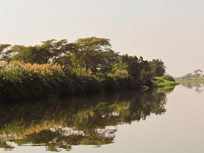
Below (top) is a photo from a river trip into the Zone Annex on the Lufira River.   It shows some of the common Acacia thorn-trees right along the river;  in this case the structure takes the appearance of a gallery forest.  


See the Google Earth Image (above) which shows one of these savannas from the air
in the Kundelungu ANNEX with the "forest" in a 
CUT-OFF MEANDER scar along the Lufira River   Note the muddy river meandering to the right vs the "dry" meander scars farther to the left.  Much of the surrounding landscape is either wetlands (the greener areas) or grassland savanna on higher better drained ground.
Above is a view of a typical fixed wetland--in the lower left foreground--with aquatic grasses/shrubs,
e.g. bulrushes near Kiubo Falls as viewed from the Lufira Bridge.  There is a dense gallery
forest
to the top right and an Acacia Savanna Woodland toward the top left.

b) Transitional Tree/Bush Savanna of the Mid-Plateau and Valleys:

This savanna formation has more scattered trees and may in fact simply be a judgement call in terms of % tree-covered (?) and probably reflect long term fallow from swidden agriculture.  The FAO / LCCS (Land Cover Classification  used by the Tervuren may--TREE SAVANNA or BUSH SAVANNA may in fact be the right classification.  Again, it depends on what threshhold measure was chosen for the classification.  But without seeing the original data and imagery it is difficult to evaluate which class best fits a particular area.  As mentioned earlier a good measure for separating forest from savanna types is the 


PERCENT TREE COVER: 

>60%  = wooded or tree savanna
25-60% = Bush/Shrub Savanna
<25% = Grass Savanna

A "bush/tree" savanna near Lukafu which is actually a FALLOW AREA.
Note the re-sprouting shrubs/bushes after the fire used to prepare for planting
A small grass/bush savanna surrounded by Dry Forest--an area which has been
put in agriculture and of course burned.  This may be the classic "transitional" savanna 
that several different systems use as classification.  Note the DRY FOREST on the hillside.
A Bush/Shrub Savanna near Katwe Station in Kundelungu
A tree-savanna and shrub savanna adjacent to each other near Lusinga Station in Upemba

c) DAMBO SAVANNAS (see also Aquatic Biotopes HERE)

Classifying them is somewhat of a conundrum--they could be classed as a savanna or as a special AQUATIC Biotope.  As mentioned previously, DAMBOS are one the most unique habitats to be found in either park.  They are often associated with small marshes, ponds, and patch forests.  In essence, they are small seasonally-flooded savannas found in very small low-lying, poorly-drained depressions on the High Katanga Plateau (see more photos below in the previous post).   In these minute depressions or on very flat surface areas, excessive water accumulates in the rainy season, and, because of underlying clay or laterite layers that impedes good soil drainage, the soil is often waterlogged.  Yet during the rather intense and longer dry season, the soil dries up thus making it hard for shallow-rooted shrubs or bushes to grow.  

But along the edges where there is a little more topography i.e. high spots, deep-rooting trees may survive and particularly farther down slope where the water in groundwater may seep out as springs allowing patch forests and riparian woodlands to form.  In sum, many of the variations in plant types (woody vs herbaceous plants) and even insects (presence of specific types of termite mounds or ant hills) can help explain landscape ecology along with, of course, the impact of fire, and animal predation and grazing effects.  Here are a few pictures again:


d) The Rocky (copper-cobalt rich) Steppe Savanna

This unique landscape is associated with rock outcrops in the region that are rich in copper and cobalt ores.  It contrasts from the predominant Open Miombo Forest by the presence of certain species that do well on the ore-rich soils, e.g. Haumaniastrum robertii, Monadenium cupricola, and Faroa malaissei.  These soils may also favor growth of unique small mushroom-like termite mounds (see previous discussion under DAMBOS regards "termite mound savanna".

Note the GALLERY FOREST in the distance.
The rocky outcrops are clearer after fire has gone through.
Some small "mushroom-like" termite mounds and
re-sprouting shrubs after fire.

e) Steppe Savanna--short and tall grass types

As mentioned earlier, of particular interest on the HIGH PLATEAU OF KUNDERLUNGU are  patches of sandy sediments/soils redeposited by wind and water from an earlier geological phase known as the Plio-Pleistocene or the so-called Kalahari  Desert Sands.  Depending on location, i.e. drainage and soil depth, these soils can provide a favorable habitat for specific kinds of grasslands--some short grasses (usually bunch grasses)--therefore the name "Steppe" Savannas. while others favor taller grasses (see photos below) from what is called LA GRANDE SAVANNE on the Kundelungu High Plateau. as well as the savannas around Lusinga Station in Upemba.  The latter is where one finds the remaining ZEBRA in DRC.  
Grassland Savanna with a lone tree near Lusinga Station in Upemba National Park
Some of what is estimated to be only 29 Zebra left in the entire DRC
Tall Grass Savanna in Kudelungu with wildflowers in foreground
(along a track) and a PATCH FOREST in the distance.


Robert (GeoBob) Ford, Rockville, Utah August 22, 2012 

Monday, August 20, 2012

Forest Biotopes in Kundelungu and Upemba

In my last BLOG entitled: Waterfalls, Rapids, Rivers, Streams and Lakes I said there would be more posts to illustrate the key Biotopes that help define the Landscape Ecology  of Kundelungu and Upemba National Parks (see more HERE).   Now, to the third post which focuses on the forest biotopes.

C. FORESTS BIOTOPES IN KUNDELUNGU and UPEMBA:

As mentioned in an earlier BLOG entitled:  Landscape Ecology of DAMBOS in Kundelungu we noted that much more is explained by topography and altitude than latitude or longitude in the vegetation sub-types that are observed.  The photo at the left shows the dominant MIOMBO Open Forest on the High Plateau near Lofoi Waterfalls (384 meters high).  Note the Gallery Forest in the canyon.  


Recall that there are THREE ALTITUDE ZONES OF INTEREST to better organize and explain what is seen. 

a) > 1500 meters (cool/cold where more humid savannas and forests are found)

b) 1000 >1500 meters (the mid-plateau valleys/hills with drier forests and savannas and more fire)

c) < 1000 Meters (and the lower valleys and basins where larger lakes, rivers, and wetlands dominate).

FOREST BIOTOPES:

Reconsider first of all the LAND CLASSES defined by the  Royal Museum for Central Africa in Tervuren Belgium in their Carte d’Occupation du Sol (see the small version below and larger PDF MAP HERE). 

They identify four classes using the FAO methodology known as the LCCS (Land Cover Classification System; as mentioned earlier that system works fine on a global scale, and if the primary goal is to define forest types by STRUCTURE which is useful for forestry and agriculture applications, e.g. computing biomass or production potentials.  Their land class  categories are:

a) Dense humid forest
b) Flooded/swamp forest (on Hydromorphic soils)
c) Open forest
d) Secondary forest

But, these categories leave out many of the sub-types (Biotopes) that we feel are important for ecological monitoring and research focused on what the park will need to manage.  

So the forest land classes recognized by ecologists and biodiversity experts differ significantly--see the website Biodiversité végétale du Katanga.  Following are the sub-types indicated in each category that they recognize.  These categories are also what the park guards and chiefs recognize though not necessarily by the full technical names.  Therefore, whether these sub-types can all be put on a map (from image analysis) at this time is a little problematic.  It may take longer and is thus something that should/could be postponed until later phases of project implementation in the General Management Plan.  Here are the general classes and sub-types recognized by the biodiversity specialists and botanists:

a) Dense dry forests

The key characteristics of this forest type is that it is a closed canopy, multi-strata forest but less tall than the “humid-Miombo” forest and one more subject to fire.  Furthermore, the emergent layer (tallest trees) lose their leaves in the dry season, and the lower strata can be evergreen shrubs or bush with or without discontinuous tall grasses.  

Two sub-types are defined by the specialists:

1-a more humid version found in western Katanga; it may be in Upemba but I’m not sure yet.  It is dominated by Cryptosepalum exfoliatum and frequently found on Kalahari sandy soils where there is very high rainfall which allows many mosses/ferns to grow profusely in the under-story.  I don't have photos for this type.

2-The dominant dry forest--typical of much of southern Katanga particularly in the Kundelungu and Lubumbashi region and is most evident in the mid-plateau and hills (between 1000>1500 meters altitude).  

Key characteristics include a marked periodicity in litter fall; a few of the tallest trees such as Entandrophragma delevoyi lose their leaves briefly, but most of the vegetation both in the understory and emergent layers is evergreen.  Some of the rather dense understory of shrubs/bushes include Rothmannia whitfieldii , Ritchiea quarrei, Diospyros hoyleana,  and Combretum gossweileri.  Many of these shrubs are denser close to settlements (specialists tell us) and are quite resistant to fire--so they offer some protection to villages from the very common fire risk of the dry season.  

This forest is the primary source for charcoal (Makala) and is under severe pressure as locals degrade the forest via practice of Swidden (Shifting/slash-an-burn) agriculture. Charcoal production is often part of the first phase of clearing.  As the forest gets progressively more degraded it opens up more to a tree-savanna.  Human use of fire is everywhere in the dry season (see photos below).


Above--a photo showing a portion of dry forest being cleared in the first phase of 

Swidden agriculture.  A charcoal production kiln (Makala) is seen and sacks ready for 
pick-up by trucks.Below--a truck picking-up charcoal along the highway as it goes through the 
Dry Forest along the highway corridor along the Kundelungu Escarpment.


Fire burning the dry forest along the Kundelungu Corridor.
Typical Dry Forest along the Highway on the road to Kundelungu that has
not been burned yet.  Note that many trees are still green though
some emergent trees lose their leaves.

b) Dense edaphic forests

These forests and woodlands are established along streams (perennial and intermittent) where soils are deep thus allowing access to groundwater even in the long dry-season when stream flows diminish--there are two sub-types:

1-Gallery forests - the trees often have a large diameter canopy, epiphyes are NOT common, but mushrooms frequent.  Several tree species are common: Khaya nyasica, Phoenix reclinata and  Newtonia buchananii.  Trees with lianas are also frequent such as Mussaenda arcuata or Vanilla polylepis.  Near the waterfalls where there is a lot of spray you often find Platycerium elephantopis.  Along smaller streams or those which are intermittent, the forest becomes more of a “woodland” that is it is a less tall, more DENSE THICKET.  We discussed these forest briefly under AQUATIC SYSTEMS--because access to water is so important.  Recall these photos from Katwe Station in Kundelungu National Park:
The dense Patch Forest (Gallery type) near Katwe Station--see Google Image below
which shows that the gallery forms around the Springs at the headwaters of a stream...
Google Earth Image of Katwe Station in Kundelungu National Park
A gallery forest at Kiubo Lodge along a tributary of the Lufira River.  Note some of the
emergent trees on the ridge that lose their leaves right at the end of the rainy-season--
it produces a type of FALL COLOR that can be quite striking.
Another variation of a gallery forest--in this case along the Lufira River in the
Kundelungu Annex.  Note the dominance of acacia-type trees.
A series of small, dense thickets (riparian woodland) along intermittent streams
in Upemba NP.  In the canyon (top left) the gallery forest is denser because of more moisture

2-Flooded/Swamp Forest - This is a quite rare forest sub-type found almost exclusively where the soil is marshy year-round and the vegetation has special breathing adaptation mechanisms to survive in water-logged soils.   Fire is non-existent in these forests.   Note the example from the Google Earth Image below:

c)  Clear / open forests

This is a mixed forest type which covers about 80-90% of the region.  Its dominant characteristic is that the trees (15-20 meters high) often have light, small leaves; they cover the ground in “umbrella” fashion and they let a lot of light through.  The understory can include grasses but not dense as in true tall grass savanna.  

All the trees and shrubs are HEAVILY FIRE ADAPTED; some plants require fire for germination of seeds which is almost universal in the dry season.  Some trees/shrubs start leafing out in the late dry season after the coldest nights of June/July have passed (in mid-august) even before the rains come.  Other species flower and put out seeds at the end of the rainy season.  So there is a marked rhythm of changing leafing and flowering patterns.  According to biologists, this forest largely replaces the Dense Dry Forest in areas with higher human density and more fire.  In the FAO/LCCS system this forest appears to be classified as either an “open” or “secondary” forest, or “tree savanna”.  This is where the FAO system may not be as useful for park management purposes in Katanga.  

There are THREE SUB-TYPES:

1-Open Miombo Forest--a forest which is very open in the understory with few shrubs/bushes.  A carpet of short green grass covers the ground in rainy season and quickly burns during the dry season without affecting the trees significantly.  There are many other plants in the understory that resprout after fire from bulbs or rhizomes (see photos below) such as Hibiscus rodanthus, Thonningia sanguinea or Sphenostylis. 
Miombo forest in Kundelungu after fire has burned the light understory grasses
Miombo on a steeper slope that suffers from frequent erosion as well as fire;
note below how the plants with bulbs or Rhizomes recover quickly after fire.


2-Miombo dominated by Marquesia macroura--a unique large, beautiful tree specie with heavy “channeled” rough bark.    Biologists claim this forest type is typical of true climax vegetation and is thus in evolutionary terms a key to understanding Miombo forest biology and environmental history.  

The oldest, denser stands are quite beautiful and are quite often of similar age structure and less affected by fire.  They are the true HUMID FORESTS typical of the HIGHEST ELEVATIONS (above 1500 meterswhere large intense fires are less frequent and dry season nights are very cold.  And, it is above the large termite mounds of the lower elevation dry forests. The age and condition of these stands of trees can provide clues to FIRE AND CLIMATE CHANGE HISTORY, i.e. they show the frequency and intensity of fires through their scars (seen in tree-ring analysis) and thus are important biological markers to the past.


3-High Termite Mound Open Dry Forest--this is a unique forest sub-type quite different from the more open Miombo forest or surrounding savannas.  The termite mounds are massive reaching to 8 meters high and 14-15 meters in diameter.  

When not cut for human use, the mounds are covered in a diversity of often spiny, xerophytic plants such as Euphorbia ingens, Begonia princeae var. princeae, etc.  These termite mounds are themselves a specialized ecosystem that can vary significantly by species of termites and presence or absence of other insects.   The termite mounds are not found much above 1500 meters; only the small termite mounds in clayey soils (a type of specialized savanna) are found on the High Plateau of Kundelungu.  See photos below: at the left is a more or less intact termite mound while the one at the right has been degraded by cutting for firewood--the latter was found closer to the urban fringe of Lubumbashi; the third photo shows more degradation and was closer to the city .


A remnant Termite mound near Lubumbashi city limits--the
unique vegetation is almost gone and now the soil is used for brick-making!


Robert (GeoBob) Ford, Rockville, Utah August 20, 2012

Sunday, August 19, 2012

Waterfalls, Rapids, Rivers, Streams and Lakes of the Kundelungu Ecosystem


B. AQUATIC BIOTOPES OF UPEMBA AND KUNDELUNGU

In my last BLOG entitled: Landscape Ecology of DAMBOS in Kundelungu I said there would be another post to further illustrate the key aquatic Biotopes that help define the Landscape Ecology of the High Katanga Plateau in Kundelungu (KNP) and Upemba National Park (UNP) (see more HERE) and downstream into the valleys and basins.   

Note again the map produced by the  Royal Museum for Central Africa in Tervuren Belgium--Carte d’Occupation du Sol (small version below and larger PDF MAP HERE).  Now, here is the second post on the aquatic sub-types.


In simple terms, the high plateaus of KNP and UNP act like a massive sponge or WATER TOWER IN THE SKY that collects water in the wet season, stores it in DAMBOS and other small wetlands/ponds discussed earlier.  But a lot more goes underground into PERCHED AQUIFERS--groundwater held in hydro-geological formations that are topographically located above the surrounding valleys and lower plateaus.  The water resurfaces in many SPRINGS and STREAMS that become major tributaries to the CONGO RIVER such as the Lualaba.   

From a TOURISM perspective, some of these RAPIDS and WATERFALLS are among the most spectacular I’ve seen anywhere in Africa or the world.  The Lofoi Falls is the highest in all of Africa at 384 meters in height (photos below).   Note the beautiful Miombo woodland on the plateau above the falls, and the RIPARIAN WOODLANDS and GALLERY FORESTS below the falls in the canyon as well as along the Lofoi River above the falls (see photo above).

Lofoi Falls in Kundelungu--highest falls in Africa (384 meters)

Smaller Falls on the grounds of Kiubo Lodge (on a tributary to the Lufira river)
Masanza Falls within Kundelungu National Park--one of its most scenic spots

But the waterfalls are much more important than just for their beauty!   The larger falls such as Kiubo Falls (below) are important BIOLOGICAL BARRIERS that affect the migration and reproduction of fish species.  For instance, Kiubo impedes the famous NILE PERCH from going upstream, while some species of river BASS (see photo below) which remain upstream within the ZONE ANNEX of Kundelungu.  

And, of course, these falls are important sources of HYDRO-POWER that are just starting to be tapped for tourist facilities such as KIUBO LODGE;  water from a year-round SPRING at the LUSINGA STATION also provides electrical power for the UNP headquarters.  And, of course, the rivers and streams create the conditions for the much of the diversity in aquatic and forest/savanna vegetation we see in the parks.

Bass caught on fishing trip on the Lufira River (left) above Kiubo Falls (right)

Many of the most important villages and towns below the Kundelungu Escarpement such as LUKAFU owe their existence to the year-round flowing streams and associated GALLERY FORESTS and SPRINGS that provide water for agriculture and other human uses (see photos above).  See Google Image above of some of the streams leading to a deeply eroded canyon on the  Upemba  Plateau and and its escapement.  See also the Google Earth Image of the KATWE Station and the surrounding Dambo and patch forests, etc.  Recall as well the photo from Katwe Station in KNP and the PATCH FOREST located there. 
A bridge over a small creek coming off the
Kundelungu Escarpment near Lukafu (see below)
  The Kundelungu Escarpment near Lukafu seen to
the east from the Mission Guest House

Lukafu Mission and some of the large trees of the
Gallery Forest found there (see below)
The dense Gallery Forest located around Lukafu Mission in late dry season--
note water still in the creek and many trees have large buttresses and leaves are green

THE FISHING INDUSTRY IN KATANGA

Eventually, further downstream these streams and rivers create the conditions for a thriving RIVER and LAKE FISHING INDUSTRY in Katanga--some of it legal and some illegal.  See lakes and wetlands in the Tervuren map discussed earlier-see PDF Map HERE).  In fact, monitoring and protecting the watersheds, wetlands, lakes, rivers, springs, and the fishing in these basins is crucial to the environmental, economic and social well-being of Katanga.  See photos below of some of the FISHING CHANNELS cut through wetlands of various types, to access LAKE UPEMBA--which is supposed to be protected--in the northwestern region of UNP.

Illegal fishing trap system within the Kundelungu Zone Annex--capturing ALL fish 

coming out of a small tributary of the Lufira River (courtesy of Alan Deverell, FZS)


The Lufira River just upstream from the Kiubo Bridge and Falls and Illegal Net Fishing
being done openly 
from the the embankment by the bridge.

Fishermen at work along the Lufira River within the Kundelungu Annex and a 

Fishing Settlement with Agriculture along the River Bank


One of the most fascinating views of fishing (legal and illegal) in the region is to see the FISHING CHANNELS cut through wetlands from along the lakes in both the Kundelungu Annex and in what is supposed to be protected Lake Upemba (see Google Earth Image below) of fishing channels.  In this case they take an almost surreal shape through the floating weeds/water plants in one of the bays of Lake Upemba.  See also the map produced by our team showing some of the channels from villages to reach OPEN WATER for lake fishing.
Fishing channels cut through floating waterplants on Lake Upemba--note the FLOODED
SWAMP FOREST on the right edge of the photo and open water in the upper left (more below)  
Fishing channels cut through lake shore wetlands to reach Lake Upemba--
see YELLOW lines from villages

UNIQUE WETLANDS BIOTOPES

What is in fact the most unique of Biotopes within the parks, in my view, are some of the WETLANDS (see again the discussion of aquatic Biotopes found on the website--Biodiversité Végétale du Katanga)--specifically see these sub-types below

a) FLOATING ISLANDS

In my view, these are truly unique and likely important fish nursery/hatchery areas (that is what locals say as well as specialists on fisheries).   There is a lot we don't know yet about this particular aquatic habitat type though it is quite easy to pick out on Google Earth (see below):

Floating Islands (some 50-100 meters or more across) which drift with wind and currents toward northern edges of Lake Upemba.  These are _non-fixed wetland (waterplants) and are quite unique here in DRC

b) FIXED AQUATIC PLANT WETLANDS

There are several sub-types  of these as well--that is where the aquatic plants are fixed to the bottom.  Many sub-types occur in small areas throughout the region often with the common WATER LILY and other typical species (see below); differentiation by the specialists looks at plant types but also water quality, e.g. clarity, sedimentation, whether there are moving currents, amount of oxygen, etc.   Again there is a lot of research needed on all these aquatic habitats and the flora and fauna associated with them is vast and also needs better study.  One of the more famous fixed water plants is the PAPYRUS--associated with the NILE RIVER drainage.


c) FLOODED / SWAMP FORESTS

An area of heavy FLOODED FOREST outside UNP (northwest region) where the remaining
ELEPHANTS in UNP are thought to be.  See Photos on Google Earth of the forest and elephants.


It is suspected that the flooded forests of northwest UNP are where most of the remaining ELEPHANTS are located--some say as many as 300 but  most likely a lot fewer.  Unfortunately, most of them now reside outside the park--we think-- where frequent reports of elephant depredation to agriculture and villagers occur.  Originally the elephant participated in an annual migration down the Lufira River valley via the lakes and wetlands in the Zone Annex of KNP that then connected them with elephant across the border from Katanga in Zambia within the Zambezi Basin.  Whether that BIOLOGICAL CORRIDOR can be reestablished is an open question and one which often comes up for discussion.  Further collaboration with scientists studying elephant migration in areas to the south would be very useful--hopefully those links can be reestablished.

SUMMARY

The wetlands, lakes, rivers, streams, springs and Dambos of KNP and UNP are among the most precious and diverse of natural resources that need protection.  And there is so much we don’t know about their biogeography, biodiversity, hydrology and how best to manage them in a sustainable manner.  And, much of the existing flora and fauna of the parks tends to be concentrated close to these aquatic habitats--in fact, most park guards in both parks use the local names of SPRINGS and STREAMS to locate themselves.  

Unfortunately, these wetland habitats are also near where some of the highest concentrations of humans are to be found near these aquatic habitats--therein is the major challenge for park management. And even more disturbing potential is that these basins have been LET OUT FOR GAS/PETROLEUM EXPLORATION...by another arm of the DRC government.  Whether that will be done or should be done, is a major point of discussion that will greatly determine whether these aquatic habitats survive for the next generation.

Coming Next:


Robert Ford, Rockville Utah, August 19, 2012