Category Archives: New South Wales

Facilitated natural regeneration in the ‘Middle clearing (Setaria plots)’ of Minyumai Indigenous Protected Area, The Gap NSW

Minyumai Rangers

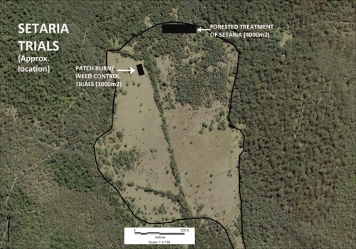
Figure 1. Aerial view of the Setaria-dominated clearing at Minyuma IPA prior to restoration work . The trial area arrowed is the location of the preliminary trial of herbiciding plus fire followed by regular spot spraying of weed regrowth. The project was then expanded to much of clearing to the left of the artificial drain running through the centre of the site (Photo Minyuma IPA)

Introduction. ‘Minyumai’ is an approx. 2000ha property owned by Minyumai Landholding Aboriginal Corporation (MLHAC) and managed by the MLAC board and the Minyumai Rangers. The property is located on the far north coast of NSW, adjacent to Bundjalung National Park and Tabbimoble Nature Reserve and was dedicated as an Indigenous Protected Area (IPA) in 2011. 

The property is largely comprised of native ecosystems, including five Endangered Ecological Communities (EECs), however it has a history of grazing in largely three sizeable clearings.  The largest and most degraded of these clearings (the ‘middle clearing’) (Figs. 1 and 2) became known to the Rangers as the ‘Setaria plots’ as it was almost completely devoid of trees, was dominated by the introduced pasture grass Setaria (Setaria sphacelata) and was subsequently divided into multiple plots for treatment and monitoring.
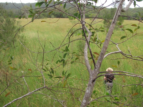
Figure 2. Closer view of the density and cover of Setaria at the site prior to treatment. (Photo Minyuma IPA)

The purpose of the work in the Setaria plots is to convert the vegetation from weed dominance to dominance by native species of the site’s prior ‘Swamp sclerophyll forest on coastal floodplains’ EEC. The project started in 2014 and is an ongoing part of the Ranger’s regular works program. 

Works undertaken. After a successful trial sponsored by Firesticks in an adjacent area, a facilitated natural regeneration approach was adopted in the Setaria plots, supplemented by some tree planting. While there were little or no above-ground natives evident among the mature Setaria at the start of the project (Fig 2), the Firesticks trial showed that the use of fire followed by precision weed spraying would result in at least some regeneration of native ground covers from the soil seed bank.
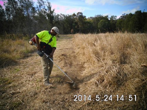
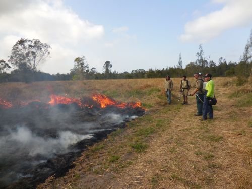
Figure 3. Firebreaks were installed at the site prior to spraying and burning and remain maintained to allow for ongoing use of fire during over time should it prove beneficial. (Photo Minyuma IPA)
Figure 4. Minyumai Rangers and visitors from a neighbouring IPA running a burn on the site. (Photo Minyuma IPA)

The plot-by-plot approach subsequently adopted involved creating firebreaks, overspraying the mature setaria with 1% glyphosate and subsequent burning of the dried weed biomass (Figs 3 and 4).  Subsequent follow-up spot-spraying was then systematically and regularly carried out.

Monitoring.  The project offered an opportunity to separate and compare burn and spray treatments with spray-only treatments – i.e.  all plots (except untreated controls) were subjected to systematic weed management but some were additionally burnt.  Species counts and cover was measured at 2 years of age and again at 4 years of age – with the ground stratum monitored using 15 quadrats (7 burn+spray, 6 spray only and 3 controls) and woody cover monitored using 18  (20m) transects (line intercepts).
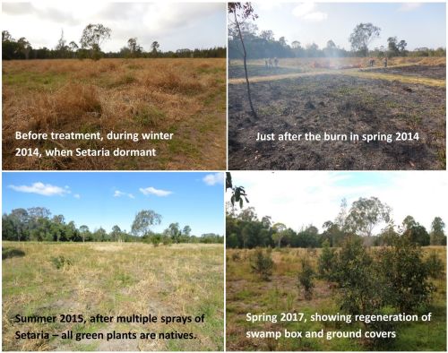
Figure 5. Photopoint monitoring showing changes at the site over a 3 year period showing treatments and gradual regeneration of natives. (Photos Minyuma IPA)

Results to date.  While the initial follow up treatments revealed extensive weed, this rapidly transitioned to native dominance over time (Fig 5) and with fairly rigorous herbicide treatment of all weed by the Rangers.  The site developed high levels of cover within 18 months. A total of  37 native species were recorded over the four years (including 5 trees, 2 shrubs,  1 vine, 18 forbs, 7 sedges and 4 grasses) .  A total of 26 weed species (1 shrub, 14 forbs, 2 sedges and 9 grasses) occurred and while weed cover reduced over time ) most species of weed remained present in the system.  

The quadrat data showed that the fire plus spot-spraying treatment resulted in improved native cover in the ground stratum (scoring an average of 3.38 on a 5 level cover scale)  compared to spot-spraying alone (scoring an average of 2.17 on the 5-level cover scale) with the controls remaining in the lowest cover level.

Transect monitoring of woody species cover over time showed a significant increase in tree cover after both fire plus spray (n=5)  and spray alone (n=9) treatments compared to the untreated controls (n=4) but there was no significant difference between the burn plus spray and spray only  treatments, which is understandable as none of the tree species form soil seed banks.
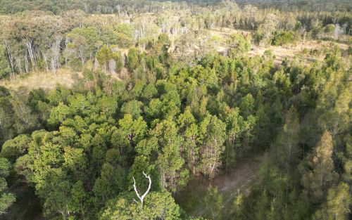
Figure 6.  Drone photo of the same quadrats from the air in August 2023, nine years after the work commenced. The dense green tree growth in the middle of the photo is all regrowth on the treated plots. Between this area and the intact Paperbark forest in the further distance there is a band of untreated land still dominated by Setaria and without native colonisation. (Note the Eucalypt circled is the same Eucalypt in the right hand background of the photos in Figure 5.)   (Photo G. Little)

Changes over time. The sedges, which were initially abundant in the understorey,  became less abundant over the two readings. Native grasses were initially far less common but increased over time, and 10 years on are still far less prevalent than sedges, which makes sense considering the wetland nature of the site.

Some  forbs, such as Buttercups (Ranunculus spp.), Gotu Kola (Centella asiatica), Pennyworts (Hydryocotyle spp.), Kidney Weed (Dichondra repens) and Native St Johns Wort (Hypericum perforatum) became frequent or abundant and remained so over the monitoring period. while other forbs such as Grass Lily (Murdannia graminea), Ludwigia (Ludwigia and Native Bluebell (Wahlenbergia sp.) remained uncommon or even rare.

Over the 10 years since the project began, the tree species Swamp Box (Lophosptemon suaveolens), Swamp Oak (Casuarina glauca) and Broad-leaved Paperbark (Melaleuca quinquinervia) have all become markedly more abundant over time through colonisation from the surrounding forest (Fig. 6) – with natural regeneration far outweighing any tree planting efforts made at the start of the project.  Forest Red Gum (Eucalyptus tereticornis) did not however increase from the remnant tree on site nor did planted seedlings of this species survive.   

Lessons learned and future directions.  When comparing the treated areas with untreated areas it is clear that the native tree colonisaton is confined to the treated areas. Although the treated areas developed high native herbaceous cover it is likely that the open niches created by the weed control and fire allowed colonisation by trees, while the dense Setaria cover prevented regrowth. 

A major challenge has been the presence of wild cattle on the property that have proved resistant to capture. This required electric fencing of the site for some years to avoid damage to plantings, although natural regeneration has now overtaken the plantings.

Critical to success was rigorous follow up prior to the weed reseeding.  Complete avoidance of reseeding was not always possible due to funding limitations or personnel changes. This has resulted in some reinvasion of Setaria in some of the plots, although the Rangers continue to manage the site well. 

As the mown firebreaks are still in place, there is potential for cool fire to be reintroduced into the site (followed by further weed control) should this be considered ecologically beneficial.  The site may also benefit from a project (being conducted in collaboration with Nature Glenelg Trust) to fill in the artificial drain visible in Fig 1.

Stakeholders and Funding bodies.  We acknowledge the valuable contributions of all the Minyumai IPA Rangers, particularly the early leadership of Minyumai Rangers, Daniel Gomes, Justin Gomes and Belinda Gomes. The Commonwealth Government’s IPA program funded the delivery of biodiversity management services by MLHAC, and funding and advice for the fire trials was provided by the NSW Nature Conservation Council’s  Firesticks initiative, with advice from Oliver Costello and Richard Brittingham. Tein McDonald advised on techniques and monitoring and Andrew Johnston provided training for the Minyumai Rangers in the first years of the project.

Contact: Mary Wilson, Minyumai Land Holding Aboriginal Corporation. Email: <admin@minyumai.org.au>

Shorebird habitat restoration in the Hunter Wetlands National Park

By Tom Clarke

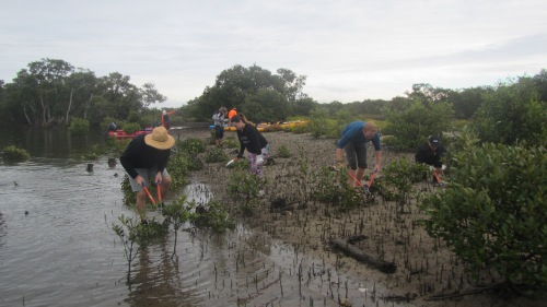
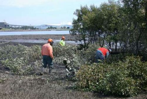
Figure 1. Contractors felling mangrove trees to restore migratory shorebird habitat structure at Stockton Sandspit.

Introduction. Thirty-seven species of migratory shorebirds regularly visit Australia, with all but one spending up to 6 months of each year here. Globally, populations of some migratory shorebirds have declined by 80% over the last 30 years largely due to habitat destruction and disturbance along the East Asian-Australasian Flyway. Within Australia, degradation of feeding and roosting habitats and disturbance are the major threats. Shorebirds need access to safe roosting places. Typically, a favoured roost is close to feeding areas, has a wide-open space and a clear view of the water. A clear view is needed for predator avoidance. A major issue for shorebirds in the Hunter Estuary, indeed for the entire flyway, is having access to several roosts so that alternative sites are available when conditions and levels of disturbance become intolerable at the preferred roost.

In the late 1990s it became obvious that vegetation encroachment was degrading major roost sites in the Hunter Estuary. Of particular concern was the viability of Stockton Sandspit, a shorebird roost site of national importance. Mangrove encroachment along the beachfront was creating a wall of vegetation and effectively blocking the view of the water. Woody weeds were also encroaching on the roost area resulting in a large decline in shorebird numbers using the roost site.

Mangrove encroachment has been documented in several estuaries along the east coast of Australia. Halting encroachment is not an option but managing specific areas that are important for shorebirds is achievable. This project involves the removal of mangroves adjacent to favoured roosting sites to maintain low, open spaces with a clear view of the water, with the intent of maintaining the sites  for shorebirds as long as they keep turning up. The potential recovery of coastal saltmarsh in these sites is an added bonus as saltmarsh is an endangered ecological community.

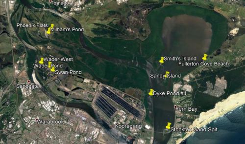
Figure 2.  Main shorebird habitat restoration sites in Hunter Wetlands National Park.

Works undertaken. Mangroves are normally protected vegetation by law. After it was agreed by various stakeholders that mangroves should be cleared from Stockton Sandspit, a permit to remove mangroves was applied for from Department of Primary Industries (Fisheries). The initial permit allowed for the removal of mature mangroves from an area of less than 1 hectare. This primary work was carried out by contractors (Fig. 1). The funding agreement required matching volunteer effort. Initially, volunteer work involved Hunter Bird Observer’s Club (HBOC) monitoring the shorebirds, but this was quickly augmented by on-ground work to remove woody weeds (including Lantana Lantana camara, Bitou Bush Chysanthemoides monilifera ssp. rotundata and Telegraph Weed Heterotheca grandiflora) and reduce the density of native shrubs (including Acacia spp, Banksia spp. and Leptospermum spp.) from the roost area. Weeding also aimed to remove exotic rushes from a small area of saltmarsh. Following initial success, other shorebird roost sites in the Hunter Estuary with similar threats were added to the program (Fig. 2). These additional areas were selected using data from the shorebird monitoring being conducted by HBOC. At each site, an initial primary effort by contractors is followed up by HBOC volunteers and others. The project has been running continuously since 2002 and represents the HBOC commitment to caring for these endangered birds.

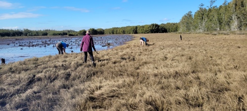
Over 10,900 volunteer hours has been accrued to date through the efforts of over 480 persons and the program is ongoing. Today, the project maintains nearly 150 hectares of shorebird habitat in Hunter Wetlands National Park. From March through to July each year, a program of works is scheduled to take advantage of favourable tides to access work areas. These cooler months are better for working in exposed areas and are when the population of migratory shorebirds is at its lowest. Removal of mangrove seedlings takes up most of the ongoing volunteer effort (Figs 3-6). The level of recruitment of mangrove seedlings varies from year to year and site to site. Factors such as tide height, wind direction and flood levels at the time of seed-drop affect the distribution of the seeds. Seed-drop usually occurs from the end of August through to early November with the majority falling through September. However, over the eighteen months of wet weather following the prolonged drought that ended in early 2020, mangrove seeds were washing up every month of the year. This required a massive effort to clear mangrove seedlings from all the sites in 2022. Thankfully the effort required in 2023 was back at a sustainable level.

Figure 3. Intrepid Landcarers cutting mangroves on Smith Island. (Photo T. Clarke)

Figure 4. Volunteers sweeping the marshes at Stockton Sandspit. (Photo T. Clarke)

Results to date. Removal of fringing mangroves and woody weeds from the roost area had an immediate positive effect. Most of the shorebirds quickly re-occupied Stockton Sandspit. This continues to be the case with Stockton Sandspit being one of the main daytime roosts used in the Hunter Estuary. Similar success has occurred at other sites but has not been quite as outstanding. These sites tend to be used by smaller aggregations of birds but are complementary to the Stockton Sandspit as different shorebird species prefer them. Some of the additional sites are frequently used as back-up roost sites when the preferred site is suffering unusually high levels of disturbance, often due to human activity.

Figure 5. Final sweeps over Milham Pond by Hunter Bird Observers Club volunteers in 2022. (Photo T. Clarke)

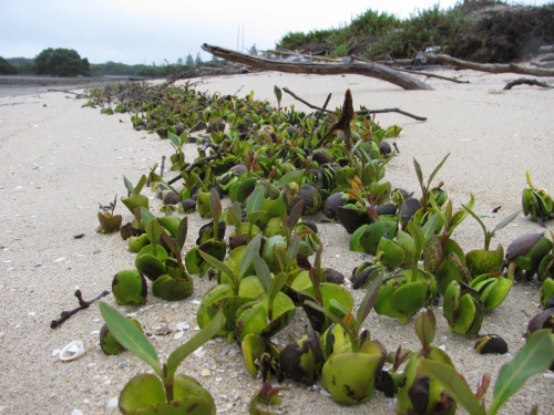
Figure 6. Mass drop of mangrove seeds happens every year at Stockton Sandspit and other places. Six months later the surviving seedlings are removed by volunteers. (Photo T. Clarke)

Lessons learned and future directions. Working on the inter-tidal areas has required that we develop an understanding of how the estuary system operates. In the early years lots of tide notes were collected for each site as well as shorebird movements. Utilising favourable tides gives better access and improves efficiency. Understanding certain shorebird behaviours also improves our efficiency. Quite often, a couple of forward scouts in the form of godwit or curlew will fly over a roost site on an inspection loop prior to the main rush of the various flocks. This is the signal for workers that it is time to vacate the site.

Many techniques and a variety of hand tools have been trialled with differing levels of success. Hand-pulling the seedlings has proven to be the most efficient. We have found that it is possible to manage the mangroves without the use of chemicals. Cutting stems lower than the next high tide results in the stumps being immersed and the tree dies. This also works for seedlings that are snapped-off. In situations where the substrate is firm enough, seedlings can be snapped off at ground level using a hoe. However, this method doesn’t work in soft mud as the plant bends away rather than breaking. Where seedling recruitment is dense, a battery-powered brush cutter has been utilised. This method was very useful during the year of continuous seeding.

While the initial work was motivated by a sense of obligation to intervene, the ongoing work provides positive feedback that maintains the energy and brings much satisfaction to the carers. This happens on every occasion that we witness the arrival of the shorebirds to the places that are restored each year, a positive joy. Maintenance of the various roost sites has become a wonderful opportunity to introduce people to shorebirds.

Stakeholders and funding bodies. At each stage of the project an initial effort of primary works was carried out by contractors and funded through various Government programs including the Australian Government’s Caring for Our Country, Envirofund and Threatened Species Recovery Fund.   The following have supported the works in some manner over the last twenty years; Twitchathon, Bird Interest Group Network (BIGNet), Birdlife Australia,  Conservation Volunteers Australia, the NSW Departments of Primary Industries and Fisheries, and Planning and Environment (and their predecessors), Hunter Bird Observers Club, Hunter Catchment Management Authority, Hunter Local Land Services, Hunter Regional Landcare Network, Kooragang Wetlands Rehabilitation Project, NSW National Parks & Wildlife Service, Newcastle Kayak Tours, Newcastle City Council, Newcastle Coal Infrastructure Group, NSW Government, Toolijooa, Trees In Newcastle, University of Newcastle.

The volunteer effort has been led by members of HBOC that make up the core team. Additional contributions have been made from other groups from time to time including: Better Earth Teams, Green Army, International Student Volunteers, TAFE students, Koora Gang, Intrepid Landcare, Worimi Green Team, Stockton Scouts, Raymond Terrace Scouts, Al Gazzali and Rigpa Buddists.

Contact information. For more information contact Tom Clarke thomas.clarke7@bigpond.com and project reports can be viewed on the HBOC website Rehabilitation Projects – Hunter Bird Observers Club (hboc.org.au).

Holistic regenerative management on a grazing farm, Allendale, Boorowa is leading to more complex native pastures and increased biodiversity

David Marsh

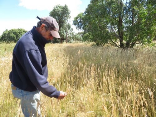
Figure 1. David Marsh among native grasses that naturally regenerated at Allendale (Photo T. McDonald).

Introduction:  When we purchased the 814 ha ‘Allendale” property in the wheat-sheep belt of the Southwest Slopes of NSW in 1966, almost all of the plants that had evolved here over millennia had disappeared although Europeans had only been here for 142 years. All that remained of the woody components were some scattered Yellow Box (Eucalyptus melliodora), Blakeley’s Red Gum (E. blakelyi) , a few White Box (E. albens), a few Apple Box (E. bridgesiana), and very few Hickory Wattle (Acacia implexa). The ground layer, which normally includes most of the biodiversity in grassy woodlands had almost completely disappeared.

During first 18 years (of the 52 years) managing our farm we took a conventional approach to farming, having a largely economic relationship with the land and applying all the latest agronomy to lift yields. In 1989 we began a shift towards a process of ‘recovery grazing’ using Alan Savory’s  Holistic Resource Management approach. This was motivated not only by our values of wanting to leave the local landscape in healthy condition but also by the fact that the conventional mixed farming model was driving our farm  into incrementally increasing debt. We realized that we were attempting to run a fixed enterprises in a variable climate of recurring drought and that wasn’t working.  Training in holistic management with a certified educator in 1999 gave me the confidence to take the process more seriously, as did my enrollment in a Grad Dip. of Sustainable Agriculture followed by a Masters degree in Sustainable Agriculture.

The basis of recovery grazing is to avoid preferential and repeated overgrazing of desirable perennials by using rotational grazing in many small paddocks (to avoid repeatedly grazing recovering plants) rather than set grazing in a few paddocks. This allows longer recovery times for the desirable native perennial grasses and avoids creating conditions best suited to annuals of less value to livestock.  The ecological and economic results of our efforts have been outstandingly positive.

Works undertaken: Our first objective was to get costs under control. Surprisingly, for us this meant discontinuing cropping. Despite intermittent large profits from cropping our analysis showed that it was not profitable overall due to the number of dry years, wet harvests and frosts. We also started managing livestock differently. We created more land divisions using conventional or electrical fencing and, in our case, piping water to each paddock rather than radiating paddocks around the dams. (A trial of the latter showed it would cause too much erosion over time.) The troughs, energiser and solar panels are moved with the cattle, each move taking less than an hour.  Fencing and water cost us $85/ha at the time and was completed in 5 years, which compared favourably to spending $70K a year on fertilisers and pesticides during our cropping phase.  Instead of 12 mobs of cattle and 26 paddocks we now have 104 paddocks (and usually one mob of cattle), running them on an agistment basis that happens to suit us. Each paddock is only grazed for a total of about 10 days per year which gives time for not only existing pasture species to recover but for new species to recruit.

Most of our vegetation restoration approach relies on natural regeneration including both groundcovers and trees.  But we have planted quite a few scattered trees and have also sown some native grass seed – either hand broadcasting after collecting it from roadsides (or where it has recovered on the property) or after mechanized seeding of purchased batches from other farmers interested in the same process.  Cattle are also agents in seed dispersal as they spread it when grazing plants with ripe seed. A technique that we have used occasionally is to intentionally move the mob from a paddock with ripe seed (after they have had a big feed)  to a paddock that doesn’t have much of the species we wish to encourage. Effectively the cattle are harvesting and sowing the seed for us at no cost.

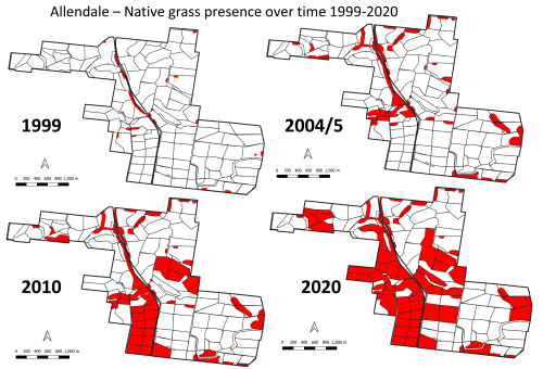
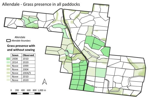
Figure 2. Increase in native grass presence at Allendale over time. (1999 -2020)

Results to date:

Woody vegetation. Tree cover on Allendale has increased from 3% cover in 1966, to over 20% in 2022 (through both tree planting and natural recruitment). Since 2010 – when it rained after a nine-year dry spell – the big remnant trees began to reproduce. The long recoveries from grazing allowed around 800 saplings (with temporary electric tape to protect them from being grazed for a few years), to survive and become trees. This is the first time any native trees have germinated and survived on Allendale in over 100 years.  Wattles (Acacia spp.) were originally direct seeded and are now recruiting.  This increase in woody vegetation and cycling provides the basis for a far more complex ecosystem on Allendale (with more insects, small reptiles, birds and a range of mammals) compared to recent previous decades.

Bird life. With these changes, a whole lot of other ecological shifts are also occurring at no cost. These days there are many thousands of quail (Coturnix sp.), finches (Neochmia spp.) and wrens (Malurus spp.) are present in increasing numbers. Dusky Wood Swallow (Artamus cyanopterus cyanopterus) and White-browed Wood Swallow (Artamus superciliosus ) come nearly every year and breed here; the Rufous Songlark (Cincloramphus mathewsi ), a ground nesting bird that we seldom saw previously, is now frequently observed. Various raptors are constantly here; the Black Shouldered Kite (Elanus axillaris), Nankeen Kestrel (Falco cenchroides), Wedge-tailed Eagle (Aquila audax), Brown Falcon (Falco berigora), Swamp Harrier (Circus approximans), Spotted Harrier (Circus assimilis) and Peregrine Falcon (Falco peregrinus) are frequent visitors. To date there have been 128 species of birds identified on the property, and we have observed informally that many of these species (and their abundance) have increased in recent years.

Grasses. Cibolabs analyses have shown that our ground cover levels have been at 100% for many years now and there have been particular increases in native grasses (Fig. 1).  We mapped the native grasses on the property in 1999 and found them present in only 1 ha out of 814 ha and confined to rocky outcrops that could not be ploughed and in a few fence corners. Repeat mapping in 2004/5 showed native grasses covered a larger area (~86ha) – with further increases mapped in 2010 (189ha) and 2020 (440ha) (Figs 2-5).  Indeed, representatives of the warm season perennials that evolved here can now be found in most if not all our paddocks even though too scattered to map.

The grass species include wallaby grasses (Rytidosperma spp.), Common Wheat Grass (Elymus scaber), spear and corkscrew grasses (Austrostipa spp.), Umbrella Grass (Chloris truncata), Kangaroo Grass, (Themeda triandra), Weeping Grass (Microlaena stipoides), Box Grass (Paspalidium distans), Arm Grass (Brachiaria milliformis), Queensland Blue Grass, (Dicanthium sericeum), Red Grass, (Bothriocloa macra), Cotton Panic (Digitaria brownii) and Wild Sorghum (Sorghum leiocladum). All these species have increased markedly in recent years, with the big stand-outs being Arm Grass, Box Grass, the wallaby grasses and Umbrella Grass (See Appendix 1).

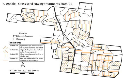
While we believe the grasses would have gradually increased over time without sowing, we have accelerated the process by sowing some species in small quantities using a disc seeder in some sites, but mainly broadcasting seed by hand from a quad bike (Figs. 3 and 4 0a.nd Appendix 1).  Seeds were also dispersed by the cattle.

Figure 3. Locations of seed sowing treatments over time at Allendale.

Figure 4 Locations of seed sowing treatments over time at Allendale.

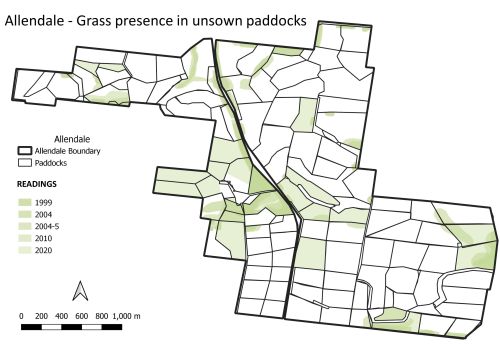
Figure 5. Native grass presence in all Allendale paddocks (with and without sowing) by 2020

Non-natives.  Achieving change has been more difficult in the paddocks where we had previously introduced exotic seed mixes including Cocksfoot (Dactylis glomerata) and Phalaris (Phalaris aquatica). These two perennial exotic grasses are highly dominant and can temporarily competitively exclude native grasses (even if the latter may still be present) –  particularly in wet seasons.  Experience suggests that this may  explain why native grass sowings in recent high rainfall years have not yet shown results (Figs 4-5).  These species are still valuable for grazing, however, as is Paspalum (Paspalum dilatatum) – which has increased – and Plantain/Ribwort (Plantago lanceolata) which is considered beneficial to the quality of the pasture.

In general, however, managing ground cover to reduce bare ground has helped managed disturbance-adapted invasive weeds such as Illyrian Thistle (Onopordum illyricum), Patterson’s Curse (Echium plantagineum), Capeweed (Arctotheca calendula) and Amsinckia (Amsinckia spp.); all of which now occur only occasionally. Importantly, we previously had an annual spraying program for some of the problematic annuals but we have not done that for 22 years;  managing ground cover to reduce bare ground goes a very long way to manage the populations of disturbance-adapted species. Any small patches of high-risk weeds (e.g. Rubus sp. and Rosa sp.) have proven manageable by mattocking out.

Lessons learned: Our goal is to live in a landscape increasing in biodiversity and to meet our economic goals. Over 30 years we were expending large amounts of money on contractors while rolling the dice against the weather, with little time for holidays.  We have found that we now usually have perennial native grasses dominating in summer and that this avoids the previous boom and bust cycle. The recovery grazing management (probably combined with reduced nutrient loads) has now resulted in more diverse native perennial pastures and avoids the cost of resowing. This allows time for habitat to develop to increase native fauna and allows us to produce time for recreation.

The benefits we have seen however, required a changed mindset.  It is quite hard for farmers to avoid intervening.  We had lots of weeds for many years because our previous management had pushed succession all over the farm back to an early state due to the creation of bare ground, even though we had sown perennials. A more mature succession took 3-5 years after ceasing sowing, weed control and overgrazing, so it did not occur overnight.  Importantly, all this required quite a philosophic conversion. Quite a lot of the farmers going down this track show a shift in attitude, characterized by patience and a greater willingness to take responsibility for land outcomes.  Such a changed mindset is not yet being entertained by the number of farmers needed to stop the slow but inexorable decline of biodiversity on farmland.   Yet more farmers are thinking about it now compared to in the last 20 years, which is an encouraging sign.

Acknowledgements: Thanks goes to my family (Mary Marsh, Skye Rush, Hugh Marsh and Alice Needham) and to my farming colleagues that have also been going on this journey (Charles Massy, Colin Seis, Martin Royds and Scott Hickman) .

Contact: David Marsh, Allendale, Boorowa NSW, Australia. Email: marsh.allendale1@gmail.com

Appendix 1. The main grass species, treatments and results at Allendale over approximately two decades.

Species Intervention Results
Wallaby grasses (Rytidosperma spp.) Very little seed has been scattered of one variety only Six varieties are now present and appeared within 3-5 years. All are spreading.
Box grass

(Paspalidum distans )

Included in the total of  ~8×40 kg bags of seed purchased from another farmer, Colin Seis, over the years) and hand dribbled in rows about 20m apart from the quad bike.  Also included in the ‘Seis mix’ disc-seeded into paddocks totalling 150ha. In 1999 only found in one or two small patches but now it is every across the property
Umbrella Grass

(Chloris truncata)

Included in the above-described ‘Seis mix’ hand dribbled and disc-seeded Was present in 1999 but now it is widespread as the seed heads are like umbrellas and tumble
Arm Grass  – Brachiaria milliformis Included in the above-described ‘Seis mix’ hand dribbled and disc-seeded Was absent when first came here.  Now it is widespread and increasing all the time.


Kangaroo grass – (Themeda   triandra) A total of half a wool pack from nearby roadside has been dispersed by hand from a quad bike over the ~15 years (split over ~four occasions). Was absent when first came here but was present on the roadside. It is not spreading rapidly but is starting to come back.


Corkscrew and tall Stipa

(Austrostipa spp.)


Pre-existed and not collected. Some was present in uncropped areas. As a pioneer it can now be seasonally abundant.
Red grass (Bothriochloa macra) A little pre-existed was original present  but some is in the ‘Seis mix’ hand dribbled and disc-seeded Some was present in uncropped areas. It is now increasing although quite slowly.
Weeping grass (Microlaena stipoides) Some seed was included in grass culms harvested from a nearby property and ‘blown’ out onto some Allendale paddocks by Owen Whittaker. Some was present in uncropped areas.  It is gradually increasing.
Common Wheat Grass (Elymus scaber)


No seed was sown but have collected from Allendale paddocks and distributed by hand a from quad bike. Some was present in 1999 but it is now spreading extensively. The species is relatively insignificant but has a place in a pasture.


Highly resilient response at a Cooma restoration site points to native plant adaptation to drought and short growing seasons

Tein McDonald

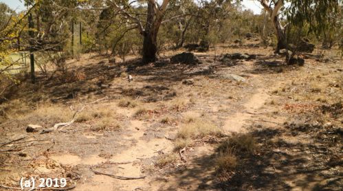
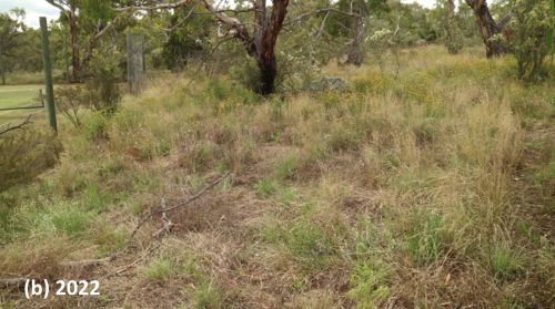
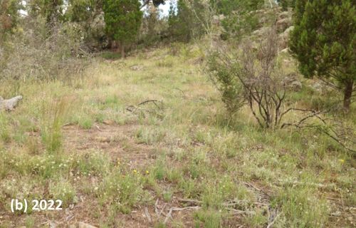
Figure 1. One of the many ‘before and after’ photo pairs showing how, (a) at the start of the project in 2019, a near-monoculture of African Love Grass was persisting even during the drought – but (b) native regeneration boomed after two seasons of good rain and regular spot-spraying of the prolific and diverse weed that regenerated along with the natives.

Introduction. Assisted regeneration works have been undertaken over three seasons at a small (4ha) but uncleared privately owned bush block on the urban boundary of Cooma in the southern tablelands of NSW. Degradation at the start of the project in 2019 reflected past land uses. Flatter areas disturbed by historic light sheep grazing and vehicular tracks appeared in poor condition, with infestations of serious weed, particularly bird spread shrubs and pasture weeds. Drought-induced dieback occurred across the site, along with evidence of overgrazing by macropods and rabbits. Most of the site’s extensive (lichen and moss-covered) granite rocky knolls, however, remained undisturbed and in good condition.

Results of the works were expected to be gradual, given that the area’s annual average rainfall was around 538 mm and growing seasons short due to the southern tablelands’ relatively cold climate. While these lower expectations were reasonable, they did not factor in the above average rainfall of the 2021-21 season and, particularly, the very high and evenly distributed rainfall of the 2021-22 growing season.

Vegetation community. The main vegetation association on the site (and the Reserve) is Ribbon Gum (Eucalyptus viminalis)-E Black Cypress Pine (Callitris endlicheri) grassy woodland, with co-dominant trees including Candlebark (E. rubida), Apple Box (E. bridgesiana), Broad-leaved Peppermint (E. dives) and Mountain Gum (E. dalympleana). Sweet Bursaria (Bursaria spinosa), Red-stemmed Wattle (Acacia rubida) and Woolly Grevillea (Grevillea lanigera) are common in the mid-storey, along with six Fabaceae shrubs. Out of the 88 native vascular plant species, 63 are herbaceous (15 grass species and 48 forb species including 13 Asteraceae) species.

Weeds. At least 40 weed species occur on site, falling into two groupings – shrubs and groundcovers. The most prevalent shrubs were Orange Firethorn (Pyrocantha spp.) and Cotoneaster (Cotoneaster spp.) The most prevalent groundcovers were African Love Grass (Eragrostis curvula), Yellow Catsear (Hypochaeris radicata), Smooth Catsear (Hypochaeris glabra), St Johns Wort (Hypericum perforatum), Hare’s Foot Clover (Trifolium arvense), Proliferous pink (Petrorhagia nanteuilii) and Fleabane (Conyza sp.).

Works undertaken. Works have focused on the systematic and careful spot-spraying of individual weeds, rigorously following up to avoid the weed recharging soil seed banks. Cut brush was also laid down in a brickwork pattern along the contours to retain waterflow (where erosion was an issue) or deter macropods (where overgrazing was an issue, see https://youtu.be/4hmLFSL_kHQ ).

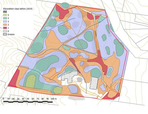
At the commencement of the works, ‘before’ photos were taken from eight pegged photopoints and at least 10 other informal ‘before’ shots across a wider range of subsites. Condition class mapping was undertaken using a 5-scale system adapted from the system used by the NSW National Trust since the 1980s.

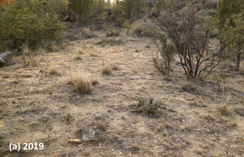
Figure 3. (a) Before and (b) after treatment at the ‘Rabbit flat’ subsite. This area was highly drought affected and overgrazed by kangaroos and rabbits in 2019. Weed trimmings were laid on the site to reduce sheet erosion and grazing. Weeds were regularly controlled, particularly African Love Grass and Hare’s Foot Clover. Drought breaking rains triggered germination of mainly Golden Everlasting (Chrysocephalum apiculatum), New Holland Daisy (Vittadinea cuneata) and range of other natives. Very little African Love Grass and other weeds now persist at this site.

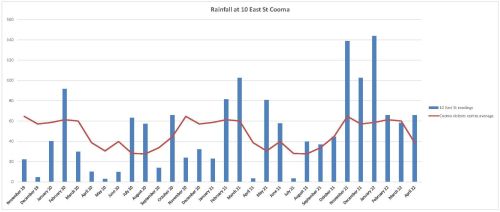
Weed treatments (totalling approx. 250 hours) were carried out over three growing seasons (Spring- Autumn) starting in December 2019 and extending till May 2022 (Table 1). By far the most hours (237) were directed to precision knapsack spot-spraying of groundcover weeds, with relatively few hours treating shrub weeds. The highest input was required in the third season, due to its exceptionally favourable rainfall (Fig. 2) when we needed to increase our inputs to treat all herbaceous weed across the whole site prior to their setting seed and recharging seed banks.

Table 1.  Hours involved in spot-spraying of groundcover weed for each of the three seasons.

Season 1  (2019-20) Season 2(2020-21) Season 3(2019-20)
77 56

Figure 2. Rainfall records at the site over three growing seasons from December 2019 to May 2022 (Blue bars is rainfall recorded at East St, Cooma; the red line the mean rainfall recorded at the Cooma Visitor’s Centre).

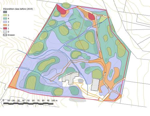
Results to date. While the site is far from fully recovered and works will be ongoing, results to date are encouraging. Figures 1 and 3 are three of many before and after photo pairs that compare the condition of all subsites prior to work with native plant recovery by January 2022 –24 months after the first drought-breaking rains. (Also see multiple photos at https://youtu.be/wjNviPl-MqY .) The condition classifications prior to works and at 3 seasons after works are shown in Figure 4.

In general most sites appear to have moved up in condition by at least one class; there is now substantially more area of medium to high condition after treatment compared to prior to treatment. However this result is still somewhat uncertain as the degree to which some of the Hare’s-foot Clover may have matured prior to spraying is unclear. The test of condition will be in Spring during the next above-average rainfall year.

Figure 4. Condition mapping (a) before and (b) after 3 seasons using a five-level condition classification system. The two maps show an increase in area of the green end of the spectrum (higher condition) and a reduction in area at the red end of the spectrum (lower condition). [The colour-coding and criteria are based on a four-level system used traditionally in the bush regeneration industry developed by the National Trust in the 1970s then modified during the 1990s by T. McDonald and subsequently resequenced to align with the 1-5 sequencing used in the 5-star system of the National Restoration Standards.]

Lessons learned and future directions.  The resilience level of this cold-climate, drought-affected plant community proved to be surprisingly high and growth relatively rapid after highly favourable rainfall. This may indeed be due to the species’ adaptation to periodic drought and short growing seasons.  Importantly (as elsewhere) such resilience also lends a capacity for natives to recover after periods of weed domination if that weed is removed.

It is logical to view the pattern of drought followed by highly favourable rainfall as somewhat similar to wildfire followed by highly favourable rainfall.  In such circumstances there is benefit in systematically treating as large an area as possible to (i) take advantage of the opportunities for rapid recovery of natives and (ii)  avoid massive and unusual recharge of weed seedbanks that could set a site’s condition back by many decades. While the landholders in this case did the work themselves and could increase or decrease work as required per season, cases relying on public funding would benefit from contingency funding being set aside for supporting additional restoration inputs in high rainfall seasons post-fire or post-drought.

Stakeholders.  The works were carried out by the block’s landholders Tein McDonald and Graeme Little.   Friends of Grassland helped with plant identification and encouragement and provided a small grant  to offset the costs of herbicide and equipment.

Contact:  Tein McDonald teinm@ozemail.com.au

Post-fire assisted regeneration at Rutidosis Ridge, Scottsdale Reserve, Bredbo NSW


Figure 1. Undamaged grassy woodland reference site occurring at high elevation at Scottsdale (Photo: Brett Howland)

Introduction. Scottsdale Reserve is a 1,328-hectare private conservation reserve, near Bredbo NSW, owned and managed by Bush Heritage Australia. For over 100 years prior to purchase in 2006 the property was utilised for grazing and cropping. While most of the higher elevation areas of the property remained intact and offered the basis for improving landscape connectivity for wildlife, the agricultural land use had resulted in conversion of the flats and lower slopes of the property to largely exotic pasture species and accompanying weed.

This case study focuses on one approx 10 ha Apple Box (Eucalyptus bridgesiana) / Snow Gum, (Eucalyptus pauciflora) grassy woodland ridge within the property – named ‘Rutidosis Ridge’ because it is the location of a small population of the Endangered plant species Button Wrinklewort (Rutidosis leptorhynchoides). Set-grazing by sheep as well as some cropping had left the site nearly wholly dominated by the landscape-transforming exotic pasture grasses African Love Grass (Eragrostis curvula) and Serrated Tussock (Nasella tricotoma). Some scattered copses of eucalypts and some herbaceous natives remained, however, suggesting that the site might have some native regeneration potential, but the number and abundance of natives on the site appeared very low and the site was very dissimilar to a nearby healthy reference site (Fig. 1).

Works undertaken. Around a decade after land purchase and the discontinuation of grazing and cropping, Rutidosis Ridge was aerially sprayed during winter with flupropinate herbicide at a low dilution (1L / ha) known to be effective on some strains of African Love Grass and Serrated Tussock without killing native grasses and forbs. While the African Love Grass and Serrated Tussock had died by the following spring as a result of this soil-active herbicide, no substantial native regeneration was observed due to the persistence of the thick thatch of dead African Love Grass (Fig 2).

  • Figure 2.  Typical site showing sprayed African Love Grass thatch even many years after aerial spraying. (Photo T. McDonald )
  • Figure 3.  Intense wildfire that passed through Bredbo, NSW in early February. (Photo” New York Times)

An intense wildfire passed through the property on 2nd February 2020 (Fig. 3). This largely consumed the thatch, exposing stony topsoils and providing opportunities for regeneration of both natives and weeds that were stored in the soil seed bank.  Anticipating the need for post-fire spot-spray follow-up after the fire to avoid any native regeneration being overwhelmed by weed, Bush Heritage Australia (BHA) collaborated on a program of regular selective treatment of weed with the restoration organisation the Australian Association of Bush Regenerators (AABR). Personnel involved both contractors and volunteers skilled in recognising natives and weeds at seedling stage capable of spot-spraying with negligible off-target damage (Fig 4).  

Because the fire had removed African Love Grass thatch and cued germination of natives and weeds, the aim was to treat all weed prior to its seeding.  This allowed the managers to (a) take advantage of the fire’s flushing out the weed soil seed bank and avoid its further recharge and (b) retain maximum open spaces for further natives to emerge and colonise. 

During the year after the fire (March 2020-April 2021), the ~10ha site had been subjected to approx. 600 person hours of spot spraying, mainly undertaken by experienced bush regenerators. This commenced in March 2000 and continued at least fortnightly during the growing season.

Figure 4. Location of comprehensively spot-sprayed areas and target-weeded areas at Rutidosis Ridge. An opportunity exists to compare differences in richness and cover of natives and weed between the two treatments, ensuring comparisons are confined to within-comparable condition classes.

What we found by 1 year of treatments.  Post-fire observations in  March 2020 revealed Snow Gum resprouting from lignotubers and roots and Apple Box and Candlebark (Eucalyptus rubida) resprouting epicormically.  A wide suite of native grasses and forbs were starting to resprout or germinate alongside diverse herbaceous weeds. Within the first 12 months of regular spot-spraying, the cover and seed production of approx. 30 weed species was very substantially reduced.  Combined with fairly evenly distributed rainfall in the follow 12 months this reduction in weed allowed ongoing increases in native species cover and diversity per unit area, with seed production likely by most native species.  There was negligible off-target damage from the spray treatments. In December 2020 over 50 native herbaceous and sub-shrub species (including at least 11 Asteraceae, 9 Poaceae, 4 Fabaceae and 2 Liliaceae) were recorded within the work zones, with cover of natives very high in the higher condition zones, but plentiful bare ground remaining in the lower condition zones (Fig. 5).  

Figure 5.  Top:  Directly after wildfire showing black stubs of African Love Grass; Middle: Volunteers spot-spraying during the growing season, and Bottom: same site after 12 months but when native grasses were curing off after seeding. (Photos T. McDonald)

Predominant weed species included recovery African Love Grass, Viper’s Bugloss (Echium vulgare), St John’s Wort (Hypericum perforatum), Yellow Catsear (Hypochoeris radicata), Common Plantain (Plantago major), a range of thistles and around 20 other weed species.

Predominant natives included speargrasses (Austrostipa spp.), Redleg Grass (Bothriochloa macrantha), Kangaroo Grass (Themeda triandra), Native Panic (Panicum effusum), Common Raspwort (Gonocarpus teucrioides), Bindweed (Convolvulus erubescens), bluebells (Wahlenbergia spp.), Common Everlasting (Chrysocephalum apiculatum), fuzzweeds (Vitadennia spp.), Bear’s Ear (Cymbonotus lawsonianus), Creamy Candles (Stackhousia monogyna), Yellow Pimelea (Pimelea curviflora subsp. fusiformis) and Native St John’s Wort (Hypericum gramineum).  Species of higher conservation interest that regenerated included Blue Devil (Eryngium ovinum) and Threatened species that regenerated included Silky Swainson’s Pea (Swainsona sericea) and Button Wrinklewort. (Some of these species are pictured in Fig. 6).

Figure 6. Some of the forbs that flowered on Rutidosis Ridge during the growing season – including the Endangered Button Wrinklework (centre) and Vulnerable Silky Swainson’s Pea.(bottom left). (Photos various.)

Gradient of condition improving over time. As expected, the sites showed a gradient of condition (Fig. 7), with highest natural regeneration capacity retained in the tree clusters and stony crest, perhaps due to these less likely to be less favoured by sheep. (The tree clusters appear not to have been used as sheep camps). By March 2020, 1 year after work commenced, all sites were on a trajectory to move to the next higher condition class, assuming successful Winter 2021 aerial spray re-treatment of African Love Grass.  (Note that, while the pre-fire flupropinate treatment would normally have a residual effect for a few years and thus preventing germnation of this species, massive germination did occur of African Love Grass in many areas, which we speculate was either due to suitable post-fire germination conditions being delayed by the presence of dead grass thatch or to a possible denaturing of the chemical by the fire.)  

Figure 7. Condition classes in the Rutidosis Zones A-E revealed during the first few months of treatment. By the end of the growing season and after regular follow up spot-spraying it was clear that all zones comprehensively treated were improving in their native: weed cover ratio except for an increasing cover of African Love Grass, the treatment of which was deferred until a second aerial spray scheduled for winter 2021. (Map: T. McDonald)

Acknowledgements: This project would not have been possible without the help of BHA and AABR volunteers.

Contact: Tein McDonald and Phil Palmer, Scottsdale Tel: +61 (0) 447 860 613; Email: <teinm@ozemail.com.au and phil.palmer@bushheritage.org.au


Crowdy Bay National Park, NSW – Assisted regeneration of a littoral rainforest patch post 2019-20 summer wildfire

Figure 1. Volunteers at the initial working bee in the burnt littoral rainforest.

Introduction. Crowdy Bay National Park is located on the NSW Mid-north coast and comprises coastal landscapes, some of which have were sand mined prior to the area’s acquisition for conservation in the 1970s. Littoral rainforest remnant and regrowth patches occur within the Park and are listed at State level and as Endangered Ecological Community and at national level as a Threatened Ecological Community. The rainforest community type forms in the dune swales, protected by Coast Banksia (Banksia integrifolia) and is dominated over time by Tuckeroo ( Cupaniopsis anacardioides) and Beach Alectryon (Alectryon coriaceus), with other rainforest co-dominants and associated shrubs, vines and groundcovers.

For over four decades,  a regeneration program has been carried out in the park by volunteers working through the National Parks Association (NPA), Mid North Coast Branch. This short summary refers to the condition of one floristically diverse littoral rainforest patch at Kylie’s Beach, half of which was burnt in a spot-wildfire in late 2019 and in which weed managment works commenced 2 years prior to the wildfire due to pre-existing weed issues (Fig 1).

The wildfire and early recovery. The wildfire burnt all the banksias on the foredune crest that were providing wind protection for the littoral rainforest, as well as 1ha of the littoral rainforest. It left the ground layer beneath both areas largely bare. In the areas burnt, all trees appeared dead. With rainfall occurring soon after the fire, post-fire coppicing of rainforest trees and Banksia commenced; with germination of native seedlings occurring with the arrival of heavy rains in December 2020 -January 2021. By mid-autumn 2020 the northern foredune section was thickly covered with colonising Blady Grass (Imperata cylindrica) that provided cover for other successional natives (Fig 2) .

Weed recovery, however, was very rapid. As early as May 2020, the site was a sea of annuals, with abundant Lantana (Lantana camara), Coastal Morning Glory (Ipomoea cairica), Cape Gooseberry (Physalis peruviana), Crofton Weed (Ageratina adenophora) and scatterings of Cape Ivy (Senecio mikanioides) and Tobacco Bush (Solanum mauritianum). Volunteers were at a loss to see how the site could be helped to regenerate. Not having previously worked in a burnt rainforest, the first though was to take out all the weeds. Under the guidance of retired regenerator Tom Clarke from the Australian Association of Bush Regenerators (AABR) however, a different approach was taken.

Figure 2. Blady Grass has covered much of the floor.

Works undertaken. Commencing in May 2020 Sue Baker from NPA and Tom Clarke from AABR conducted monthly working bees to strategically remove weeds. The approach was to  regard the weeds as the new canopy cover and primary colonisers, providing invaluable shade and moisture retention for the regenerating rainforest species. It was agreed that the main initial objective was to see the re-establishment of a canopy, however low, to protect the ground moisture levels and any recovering herb layer. At this point any woody weeds were considered allies in that they were resprouting along with many native pioneer species. Treatment of woody weeds was selective and dependent upon direct competition with native plants. Instead, treatment of weed vines and creepers was targeted, with removal of Morning Glory and Cape Ivy a priority, at least to the edge of the burnt zone.

Subsequently, apart from preventing the spread of Cape Ivy and removing dense infestations of fruiting Cape Gooseberry, the method was to remove weeds only where they were competing with native seedlings with as much removal of their fruits and seeds as possible, followed by thinning out later where helpful. By January 2021, native ground cover had recovered sufficiently to remove the annuals, some of which were 2m high. Over time, the selective treatment of woody weeds has continued as more and more native regen appeared. By taking this approach we have left nature largely to do its own thing with minimal detrimental impact from weeding.

In addition, we have taken the view that the wildfire was not soley a negative; it has also provided an opportunity to address some of the long-standing weed issues in the broader area of Kylie’s Beach including that of Glory Lily (Gloriosa superba) and Golden Wreath Wattle (Acacia saligna) which the fire stimulated to germinate from the soil seed bank in their thousands.

As well as the weed management work, over a kilogram of native seed was broadcast in mid-summer 2020 in the hope it might improve recovery of the ecosystem.

Volunteer visits. After a site inspection tour on 14th May 2020 there have been at least 17 visits to Crowdy Bay National Park where regeneration works has been carried out, not only in the littoral rainforest, but also in the broader Kylie’s beach area. These occurred in May (1 visit), July (3 visits), August (4 visits involving 12 volunteers), September (2 visits), October (4 visits), November (1 visit) and lately in January 2021 (2 visits).

Figure 3. Tuckeroo coppicing from the burnt stump.

Figure 4. Lillypilly coppicing.

Results to date.  The site has demonstrated itself to have high levels of native resilience, having been in relatively healthy condition apart from per-existing weed infestations. High levels of rain in the 2020-21 summer has promoted extensive and vigorous growth. At February 2021, the forest floor was a carpet of native vegetation and some areas knee-high in dense native grasses. Less care in selecting woody weeds for treatment is now required.

Much of the regeneration is from germinating seeds but some has been from re-sprouting rootstocks, resprouting stems or coppicing from the bases of trees, including rainforest trees (Figs 3 and 4) although some large trees are dead  (See Table 1). With the assisted regeneration work (i.e. strategic weed removal post-fire) the site is quickly shifting from a predominantly weed-dominated post-fire succession to one dominated by native plants.

There is no evidence that the sown seed has yet contributed to the regeneration at this stage.  Native regeneration was occurring across the area prior to the date when germination of sown seed would be expected and it is now clear that additional seed was not required.

Plans for ongoing management.  The continued wet and humid conditions in summer 2021 have provided highly favorable conditions for regeneration. During 2021 the volunteers will try to keep up with the work at Kylie’s Beach through regular bush regeneration camp outs (as organised for many years, except 2020 which was cancelled due to COVID-19 restrictions). Work plans for the next camp-out have been scheduled to include the Kylie’s Beach littoral rainforest site and will include follow-up treatment of vines and Crofton Weed. Full recovery is likely to take years as the recovery process moves at its own pace.

Two major issues remain – dense ground and canopy cover of coastal morning glory in the area will need meticulous treatment. Also an entire drainage line on the steep, rocky cliff face behind the dune is densely infested with Crofton Weed that must be left in place to stabilize the slope until sufficient native cover takes hold. Volunteers were able to remove flowers from the Crofton Weed for a certain distance up the slope. Contractors will be needed in 2021 to deal with the upper slope.

Acknowledgements: We thank the organisation and leadership of NPA group.  The fact that this was already in place prior to the fire, was a key to the success of the work to date. This group has an outstanding history and connection with many sites in the Park over many years. The linking of AABR to the project provided additional support in project design and facilitating additional volunteer from the ABBR network for the post-fire restoration side of the program.

Contacts:  Tom Clarke AABR 0418411785 and Sue Baker (NPA MNC branch)

Table 1. Kylie’s Beach Littoral Rainforest Post Fire Restoration  – responses of native and exotic species (Exotics marked with an asterisk)

Scientific name Common name Response of the species at this site Notes
Grasses
Imperata cylindrica Blady Grass Resprouted Dominating burnt floor devoid of canopy
Oplismenus aemulus Basket Grass Resprouted and germinated Near edge of existing canopy
Ehrharta erecta* Panic Veldtgrass Germinated Hillside on open ground near crofton weed
Eriochloa procera Spring Grass Germinated Near edge of existing canopy
Scramblers and Climbers
Marsdenia flavescens Hairy Milk Vine Resprouted and germinated At edge of existing canopy
Senecio mikanioides* Cape Ivy Resprouted Remnants creeping through grasses, has been heavily targeted.
Ipomoea cairica* Mile-a-minute Resprouted and germinated Existing condition taking advantage, targeted for weeding
Desmodium sp. (varians?) Desmodium Germinated Carpeting over slope to dune swale
Glycine sp. (tabacina?) Love Creeper Germinated Carpeting over slope to dune swale
Sarcopetalum harveyanum Pearl Vine Resprouted and germinated Near edge of existing canopy.
Stephania japonica Snake Vine Resprouted and germinated Near edge of existing canopy or large remnant structures
Dioscorea transversa Native Yam Resprouted Near edge of existing canopy or large remnant structures
Passiflora edulis* Blue Passion Flower Resprouted and germinated Single isolated plant. Previously overlooked?
Rubus parvifolius Native Raspberry Resprouted and germinated Creeping through rank grasses
Cayratia clematidea Slender Grape Resprouted and germinated Creeping through rank grasses
Cissus antarctica Kangaroo Grape Resprouted Mostly at edge of existing canopy.
Tetrastigma nitens Three-leaved Water Vine Resprouted Near edge of existing canopy
Flagellaria indica Whip Vine Resprouted Isolated individuals searching for structure
Geitonoplesium cymosum Scrambling Lily Resprouted Creeping through rank grasses
Smilax australis Austral Sarspariila Resprouted Moving into grass floor plus climbing burnt structures.
Ground Covers and Herbs
Hydrocotle bonariensis* Pennywort Resprouted Associated with commelina in low swale
Commelina cyanea Scurvy Weed Resprouted Feature of low swale within open floor area; also underneath grasses.
Melanthera biflora Melanthera Resprouted Carpeting top of rise from dune swale
Tufted Plants
Crinum pedunculatum Swamp Lily Resprouted Seaward edge to dune swale
Dianella congesta Coastal Flax Lily
Lomandra longifolia Mat Rush Resprouted and germinated Isolated individuals, seedlings and survivors
Ficinia nodosa Knobby Club-sedge Resprouted Seaward side pushing up from dune swale below
Cyperus sp. (sanguinolentus?) Sedge Resprouted Associated with commelina etc in swale near False Bracken
Alocasia brisbanensis Cunjevoi Resprouted Scattered near edge of existing canopy or structures.
Ferns
Doodia aspera Rasp Fern Resprouted Mostly near edges of existing canopy
Pellaea falcata Sickle Fern Resprouted Mostly with grass at edge of existing canopy
Calochlaena dubia False Bracken Fern Resprouted Dense patches on floor adjacent to Blady Grass
Dicksonia antarctica Treefern Resprouted Unaffected individuals near edges
Shrubs
Acacia longifolia (var. sophorae?) Golden Wattle Germinated Seedling growth mostly seaward edge of floor.
Breynia oblongifolia Coffee Bush Germinated Isolated individuals from seedlings
Banksia integrifolia Coastal Banksia Resprouted and germinated Coppicing from burnt stumps plus seedlings
Physalis peruviana* Cape Gooseberry Rampant pioneer exotic targeted for weeding
Solanum nigrum* Blackberry Nightshade Germinated Rampant pioneer exotic targeted for weeding
Lantana camara* Lantana Resprouted Rampant pioneer exotic targeted for weeding
Poyscias elegans Celerywood Germinated Scattered seedlings
Trema tomentosa var. viridis Native Peach Germinated Pioneer from seedlings; competing well
Conyza sumatrensis* Tall Fleabane Germinated Rampant pioneer exotic targeted for weeding
Notelea venosa? Mock Olive Resprouted Coppicing from burnt stump.
Bidens Pilosa* Cobbler’s Pegs Germinated Rampant pioneer exotic targeted for weeding
Phytolacca octandra* Inkweed Germinated Isolated patches
Ageratina Adenophora* Crofton Weed Resprouted and germinated?? Isolated patches on floor plus large, dense infestation covering hillside soak
Chrysanthemoides monilifera* Bitou Bush Resprouted and germinated Isolated individual plants
Trees
Cupaniopsis anacardioides Tuckeroo Resprouted and germinated Coppicing from burnt stumps plus seedlings
Wilkiea huegeliana Wilkiea Resprouted Coppicing from burnt stumps
Homalanthus populifolius Bleeding Heart Germinated Pioneer from seedlings; competing well
Alectryon coriaceus Beach Tamarind Resprouted Coppicing from burnt stumps.
Solanum mauritianum* Tree Tobacco Germinated Pioneer exotic targeted for weeding
Ficus rubiginosa Port Jackson Fig Resprouted Coppicing from burnt stumps
Laurel type Coppicing from burnt stumps
Synoum glandulosum Scentless Rosewood Resprouted Coppicing from burnt stumps

Post-wildfire recovery at a wet sclerophyll/rainforest ecotone close to housing at Wanganui NSW

Joanne Green

Introduction. The Mt Nardi fire, on Wed 13th Nov 2019, provided an opportunity to observe the effects of a relatively low intensity burn at a wet sclerophyll/rainforest ecotone on an 18 acre rural residential property at Wanganui, NSW.

Prior to the fire the vegetation had not been burned for 50 years and was dominated by Brush Box (Lophostemon confertus), Red Bloodwood (Corymbia gummifera) and Forest Oak (Allocasuarina torulosa) –  with a mesic understory of rainforest species including Red Bopple Nut (Hicksbeachia pinnatifolia ), Jackwood (Cryptocarya glaucescens), Bangalow Palm (Archontophoenix cunninghamiana)  and  Tree Heath (Trochocarpa laurina).  The forest was on a trajectory from wet sclerophyll towards a palm-dominated forest.

Since the fire,  the recovery has reset the ecosystem to a wet sclerophyll community with a diversity of heathy species in the understorey, although there is also massive germination and resprouting of rainforest species that indicates that the rainforest understorey will return over time. Table 1 at the end of this summary shows the recovery of both sclerophyll and rainforest species, and their presence or absence above ground prior to the fire.

Figure 1. Dead Bangalow Palm amid a sea of Brown Kurraong seedlings post fire. (Photo: J. Green)


Figure 2. Resprouting saplings of (a) Bolwarra and (b) Creek Fig (Photo J. Green)

Mortality and recovery.

Resprouting:  The fire varied in intensity as it burned downslope. The highest intensity was at the edge of the National Park at the highest elevation above a rocky face. Turpentine (Syncarpa glomulifera), Lomandra (Lomandra longifolia), heath species and younger trees appeared to be killed by fire. While Turpentine has not yet resprouted, Lomandra has resprouted and heath species such as Acacia and Zieria have regrown from seedlings.  Bangalow Palms (Archontophoenix cunninghamiana) are completely dead wherever the fire burned to their tops (growing points) and perhaps many more are dying, indicated by the presence of a fungus on their trunks. One tall Brushbox (Lophostemon confertus) is completely dead.

A community with old growth Forest Oak (Allocasuarina torulosa) is further downslope closer to the rainforest lined creek. The roots system of these trees, burned under the ground and the fire could only be doused by digging out the peat-like root system. Some of the Forest Oaks died but most have recovered.  Taller canopy trees of rainforest and sclerophyll species died back but are resprouting. Midstorey trees, less than 8m, are largely dead, dying or resprouting from the base (coppicing).  The trunks are completely dead but there are many root suckers of species such as Jackwood (Cryptocaryia glaucescens), Bolwarra (Eupomatia laurina), Grey Possumwood (Quintinia verdonii) and the rare Red Bopple Nut (Hickbeachia pinnalifolia).

Treeferns such as Cyathea australis, C. cooperi and C. leichhardtiana were the first resprounters and ground ferns such as Soft Bracken (Hypolepis muelleri) are proliferating following the  rain since the fire event.

Figure 3. Proliferation of rainforest pioneers germinating after fire including Poison Peach (Trema aspera), Pencil Cedar (Polyscias murrayi) and Bleeding Heart (Homolanthus populifolius). (Photo J. Green)


Figure 4. Heath species such as Zieria (Zieria smithii) pictured at the right. germinated alongside rainforest species despite not being in the previous above-ground flora. (Photo: J. Green)

Seed germination: Rainforest species germinating included: Red Cedar (Toona ciliata) , Pencil Cedar (Polyscias murrayi), Brown Kurrajong (Commersonia bartramia), Red Ash (Alphitonia excelsa) and Corkwood (Duboisia myoporoides).  Heath species recruiting included: a large amount of Tree Pea (Daviesia arborea), Zieria (Zieria smithii), Prickly Acacia (Acacia ulicifolia), and Hibbertia spp. Herbaceous species included: Forest Lobelia (Lobelia trigonocaulis),  Kreysigia (Tripladenia cunninghamii), Hairy Tree Foil Desmodium rhytidophllum and other vines of the pea family are covering large areas of the ground.

Weed regeneration

Alongside the natives,  diverse weeds are proliferating after fire, representing all growth forms. Some weed species may be playing a facilitation role for rainforest recovery, while others should be  targeted to reduce their inhibiting effect on native regeneration. Given the level of regeneration across functional groups, this community is likely to benefit from assisted natural regeneration focusing on removal of weed that is competing with native regeneration.  Where possible it is desirable to use the opportunity of the wildfire to deplete populations of weed at the site to increase the community’s resilience to future fire. No reintroductions or seed input is needed at the site.

Future directions.  Consideration needs to be made as to which ecosystem will be the target for future management.  Retaining a sclerophyll overstorey is desirable for habitat values and hence allowing replacement of those individuals that died will be important for future forest dominants.  The use of fire as a control method to control the massive germination of rainforest seedlings and Bangalow Palm dominants is under consideration. For the healthy understorey elements to remain in the soil seed bank for future regeneration would at least require their retention until they have flowered, fruited and recharged the soil seed bank.  But consideration will be given to retaining more fire-resistant rainforest vegetation on the side of the forest closer to the house to act as a fire buffer to supplement the existing 50m fuel free zone.

Contact: Joanne Green, Email jogreen909@gmail.com

Table 1.

SPECIES HABITAT TYPE PRESENCE /ABSENCE BEFORE FIRE RECOVERY MODE
Botanical Name Subtropical Rainforest = STRF, Wet Sclerophyll = WS, Dry Sclerophyll = DS P /A Seed = S, Epicormic growth = EP, Coppice = COP, R = Resprout
TREES AND SHRUBS      
Acacia ulicifolia DS P S
Acacia melanoxylon STRF P S
Acmena smithii STRF P COP
Allocasuarina torulosa WS P EP
Alphitonia excelsa STRF P S/COP
Alphitonia petrei STRF P S
Archirhodomyrtus beckleri STRF P COP
Archontophoenix cunninghamiana STRF P S/Dead
Breynia oblongifolia STRF P S
Commersonia bartramia STRF P S
Cordyline rubra STRF P COP
Corymbia intermedia WS/DS P EP
Cryptocarya erythroxylon STRF P COP
Cryptocarya glaucescens STRF P COP
Daviesia arborea WS/DS A S
Diospyros pentamera STRF P COP
Diploglottis australis STRF P COP/Dead
Duboisia myoporoides STRF P S/COP
Elaeocarpus reticulatus STRF P COP
Eucalyptus microcorys DS P EP
Eucalyptus pilularis DS P EP
Eupomatia laurina STRF P COP
Flindersia bennettii STRF P COP
Ficus coronata STRF P S/COP
Glochidion ferdinandi STRF P COP
Hickbeachia pinnalifolia STRF P COP
Homalanthus populifolius STRF A S
Jagera pseudorhus STRF P COP
Leptospermum petersonii DS P COP/S
Lophostemon confertus WS P S/COP
Macaranga tanarius STRF A S
Melicope elleryana STRF P S
Myrsine variabilis STRF/WS P S
Nematolepis squamea DS A S
Neolitsia dealbata STRF P COP
Ozothamnus diosmifolius WS/DS P S
Persoonia media WS P S
Pilidiostigma glabrum STRF P COP
Polyscias  murrayii STRF A S
Polyscias sambucifolia STRF A S
Quintinia verdonii STRF P COP
Schizomeria ovata STRF P COP
Solanum mauritanium Non – Native A S
Syncarpia glomulifera WS P COP/Dead
Synoum glandulosum STRF P COP
Trema tomentosa STRF P S
Trochocarpa laurina WS P COP
Wilkea huegeliana STRF P S
Zieria smithii  WS A S
       
VINES AND CLIMBERS      
Billardiera scandens WS A S
Geitonoplesium cymosum STRF P S
Desmodium rhytidophllum WS/DS A S
Hibbertia dentata STRF P S
Hibbertia scandens STRF/WS P S
Kennedia rubicunda STRF A S
Morinda jasminoides STRF/WS P S
Rubus moluccanus STRF/WS P S
Smilax australis STRF/WS P S
Stephania japonica var. discolor STRF P S
       
FORBES AND GROUNDCOVERS      
Alpinia caerulea STRF/WS P R
Dianella caerulea STRF/WS P R
Entolasia stricta WS P S
Gahnia appressa WS P S
Lepidosperma laterale WS P R
Lobelia trigonocaulis STRF/WS P S/R
Lomandra longifolia WS P R
Oplismenus aemulus STRF/WS P S
Oplismenus imbecillis STRF/WS P S
Oplismenus undulatifolius STRF/WS P S
Pimelea ligustrina subsp. ligustrina STRF/WS A S
Tripladenia cunninghamii STRF/WS P S/R
Viola banksii STRF/WS A S
       
FERNS      
Adiantum hispidulum STRF/WS P R
Blechnum cartilagineum WS P R
Blechnum nudum STRF P R
Cyathea australis STRF/WS P R
Cyathea cooperi STRF P R
Cyathea leichhardtiana WS P R
Doodia aspera STRF/WS P R
Hypolepis muelleri STRF P R
Pteridium esculentum STRF/WS p R
Sticherus lobatus STRF p R


Regenerating and planting of rainforest buffers to protect homes and rainforest from future fires

Joanne Green, Rainer Hartlieb and Zia Flook

Introduction. The wildfires of November and December, 2019, burnt over 5,500 hectares of Nightcap National Park and the surrounding areas, including the rural communities of Huonbrook and Wanganui inland from Byron Bay in NSW, Australia. The fires occurred during a period of extreme fire risk after 2 years with below average rainfall. They mainly burnt the sclerophyll forest along the ridgetops, but the extreme conditions also saw fire burn the edge of the rainforest where it was eventually extinguished.

This summary reports on actions on one multiple occupancy property in Huonbrook, NSW after an ember attack from the Mt Nardi fire entered the property in the early hours of the 9th November 2019. During the fire, residents evacuated.  Their homes were saved but they returned to find that the fire burnt an area of eucalypts  – mainly Flooded Gum (Eucalyptus grandis) and several bamboo species that had been planted during the late 20th century to reforest an area where subtropical rainforest had been-long cleared for dairy farming. The plantings had also become infested with weed including Camphor Laurel (Cinnamomum camphora) and Lantana (Lantana camara), the latter increasing their combustibility under dry conditions. After the fires, the landholders sought solutions that could provide a more fire-resistant barrier to reduce potential fire threat to homes and the nearby remnant rainforest. As a result they opted to restore the buffer zone with the more fire-retardant subtropical rainforest that had been the original native vegetation of the area.

Figure 1. Multiple native and weed species germinated after fire. (Photo Rainforest 4)

Figure 2. Prolific germination of the wind-dispersed Red Cedar (Toona ciliaris), among many rainforest species germinating and resprouting on site. (Photo Joanne Green)

Works undertaken. Starting in March 2020, with support from Madhima Gulgan’s Indigenous bush regeneration team, Huonbrook residents and landowners commenced work on the site. The first task in any zone to be treated was to clear the debris sufficiently to allow access for weeding and planting. The second task was to identify any subtropical rainforest species (germinating after the fire) that were to be retained and to note areas that were bare and would be suited to plantings. (No planting was done where there was any natural regeneration.)  The third task was to remove prolific exotic weeds, while protecting the natives, with the final task involving planting, staking and tree guarding.

The main weed species on site were Lantana, Running Bamboo (Phyllostachys spp.), Kahill Ginger (Hedychium gardnerianum), Winter Senna (Senna x pendula), and Inkweed (Phytolacca octandra). A total of 12 rainforest tree species germinating included the secondary species Red Cedar (Toona ciliaris) and Celerywood (Polyscias elegana) and the pioneers Red Ash (Alphitonia excelsa), Macaranga (Maccaranga tanarius) and Bleeding Heart (Homolanthus populifolius). A total of seven native rainforest understorey species  resprouted including Dianella (Dianella caerulea), Native Ginger (Alpinia caerulea.) and Cordyline (Cordyline petiolaris).

Figure 3. Madhima Gulgan’s Indigenous bush regeneration team assisting  landholders with post-fire weeding.  This work revealed where understorey natives were regenerating and where gaps required planting. (Photo Rainforest 4)

Some  300 rainforest trees (around 30 species) and another 300 understorey plants have been planted at the site to date from May-Sept 2020, with a total of 3600 plants proposed to be planted on additional fire affected sites as part of this project. Locally occurring tree species planted to date include Lillipilly (Acmena smithii), Native Tamarind (Diploglottis australis), Firewheel Tree (Stenocarpus snuatus), and Long-leaved Tuckeroo (Cupaniopsis newmanii) Understorey species planted included Dianella, Lomandra, Native Ginger and Cordyline.  All required tree guards to protect them from browsing by the native Red-necked Pademelon (Thyogale thetis).

After the planting, more natural regeneration of weed and natives occurred, particularly of the ground ferns; Harsh Ground Fern (Hypolepis muelleri), Binung Fern (Christella dentata), and Soft Treefern (Cyathea cooperi). Since the rain in autumn 2020 and the above average rainfall year that has followed, the landholders are managing weed in the regeneration and plantings together and work is now extending into the unburnt buffer zone.

Figure 4. A total of 300 containerised plants were installed to reinstate lowland subtropical rainforest on the site and provide a less fire prone vegetation buffer to protect residential dwellings. (Photo Joanne Green)

Figure 5. Diagram of location of the buffer plantation in relation to dwellings. (Diagram. Joanne Green)

Results to date: Nearly 12 months after planting has seen a nearly 100% survival rate and many of the planted trees have grown to an average height 1-2m. The number of native rainforest species on site now is approximately 25 tree and 23 understorey species and vines.  Ferns cover 40% of the site. The difference between the number planted and the number on site (18 species) can be attributed to natural regeneration.

Further colonisation of rainforest species is expected over time. Whilst, in hindsight, we see that much of the site could have been captured by natives as a result of  weed management alone, the planting has added a broader diversity of species, and will accelerate the process of succession to a more mature rainforest stand.

Acknowledgements: The Madhima Gulgan Indigenous bush regeneration team was funded by the inGrained Foundation and the Rainforest 4 Foundation. See https://www.rainforest4.org/. Technical advice was provided by Joanne Green.

Contact: Rainer Hartlieb, Huonbrook landholder, rainerhart@aapt.net.au and Zia Flook, Rainforest 4 Foundation Conservation Program Manager, zia@rainforestrangers.org

The Role of Swamps in Drought: Popes Glen Creek, Blackheath

Alan Lane

Introduction

The important role of swamps in water storage and as regulators of stream flow has been well documented (10.1016/j.geomorph.2018.03.004). Previous EMR project summary reports on Popes Glen Creek, Blackheath, have described the establishment of a swamp on the former highly degraded and weed-infested silt plug at the headwaters of the creek.  (See links at end of this summary.)  That 18-year long project has been documented in “The Full Story”, https://dl.bookfunnel.com/ebgais2pxn and an 8-minute summary video can be viewed at https://www.youtube.com/watch?v=610sas330EQ

The recent severe drought in New South Wales provided the opportunity to monitor the water table in this swamp in the absence of rain and compare the impact on the swamp vegetation with that on more elevated and drier slopes nearby.

How we measured the water table. Six piezometers were installed at the start of this rehabilitation project, located about 50 m apart and midway between the edges of the long, rectangular silt plug. These went down to the bedrock, at depths of between 113 and 152 cm and were used to monitor water table depth and also for sampling water quality and stygofauna.

What we found. During periods of normal or above average rainfall (e.g. September 2019), the water table at each of these bore holes was typically at the depth below soil surface shown in Table 1.

Levels fell almost to bedrock during the drought (Oct 2019 – Dec 2019), before recovering after rains in January and February 2020 (Tables 1, 2). 

Table 1. Water table depths during normal and below-average rainfall periods.

Bore hole number
Depth below surface (cm) 1 2 3 4 5 6
Normal rainfall period (Sept 2019) 31 2 7 11 23 9
After drought period (Dec 2019) 103 106 121 103 123
After recovering rainfall (Feb 2020) 29 0 12 21 13

Table 2.  Rainfall, October 2019 – February 2020.

Month Rainfall (mm)1 5-year average (mm)2 % of average
September 2019 81.4 53.6 151.6
October 2019 23.8 76.7 31.0
November 2019 26.4 82.2 32.1
December 2019 0.4 69.5 0.6
January 2020 99.2 127.9 77.6
February 2020 560.4 183.6 305
  1. From Bureau of Meteorology, Mount Boyce, NSW
  2. From willyweather.com.au, Mount Boyce, NSW

During this period of extreme drought, the vegetation on the slopes above the Popes Glen swamp manifested extreme water stress in a way never before seen (Figs. 1, 2). Many of these extensive expanses of Coral Fern (Glycaenia dicarpa), stands of Fishbone Water Fern (Blechnum nudum) and individual Black Tree Fern (Cyathea australis) plants have not recovered and now appear unlikely to do so.

Figure 1. Expanses of severely water-stressed Glycaenia dicarpa on slopes above the Popes Glen swamp.

Figure 2. Many of the Blechnum nudum and Cyathea australis on slopes above the swamp have failed to recover.

In marked contrast, the vegetation in the swamp area (Fen Sedge (Carex gaudichaudiana), Tassel Sedge (Carex fascicularis), Tall Spikerush (Eleocharis sphacelata) and Juncus sp.) remained lush and vigorous (Fig. 3), suggesting it was sustained by the supply of water retained in the substrate.

This supply was progressively depleted during the drought and the water table had fallen almost to bedrock before the rains in January (Tables 1, 2).

Figure 3. Vegetation in the Popes Glen swamp remained lush throughout the drought.

Implications. It seems inevitable that this water supply would have been completely exhausted had the 2019-2020 drought lasted longer. Temperate Highland Peat Swamps on Sandstone (THPSS), including the Popes Glen swamp, appear threatened by the even more prolonged droughts anticipated as climate disruptions due to global heating become more marked.

Acknowledgements. This work was supported by Blue Mountains City Council and funding from the Environmental Trust of NSW.

Contact. Alan Lane alanlane388@gmail.com

See also EMR Project Summaries:


Beyond the 1990s, beyond Iluka – koalas and citizen science – UPDATE of EMR summary

Daniel Lunney, Lisa O’Neill, Alison Matthews, Dionne Coburn and Chris Moon

[Update of EMR summary – Lunney, Daniel, Lisa O’Neill, Alison Matthews and Dionne Coburn ( 2000) “Contribution of community knowledge of vertebrate fauna to management and planning. Ecological Management & Restoration, 1:3, . 175-184. https://onlinelibrary.wiley.com/doi/10.1046/j.1442-8903.2000.00036.x]

Key words: national parks, SEPP 44, adaptive management, social criteria, extinction, wildlife survey, coastal forests.

Figure 1. Interest in local wildlife among residents and visitors to the north coast village of Iluka was growing in the 1990s, providing an opportunity for community involvement in our wildlife survey designed not only to gain information but to raise awareness. (Photo Dan Lunney 1991.)

Introduction. Our EMR feature published in 2000 reported on research that commenced in 1997 when we set out to identify the species and locations of the vertebrate fauna of Iluka peninsula, at the mouth of the Clarence River NSW, Australia. Much of the peninsula had been damaged by post war sand mining and creeping urban growth. We had recognised that there was a growing interest by local communities in conserving biodiversity (Fig 1), as Iluka had residential areas not far from a magnificent Nature Reserve (Iluka NR) and a National Park (Bundjalung NP). We conducted a community-based survey, sent to every household, which used a large, coloured map of the peninsula and a questionnaire asking respondents to mark the locations of the fauna they had seen. As a result of the survey, we concluded that vertebrate fauna does live on private land, that local knowledge is valuable, and that there is both community concern over declining fauna and support for planning, management and long-term fauna research.

Figure 2. Two junior volunteers learning radio-tracking to locate koalas, Iluka Peninsula. (Photo Dan Lunney 1992)

The rise of citizen science. We were not the first to use a community-based survey for wildlife in NSW. A team (Philip Reed and Dan Lunney) in 1986-87 greatly expanded on some skilled, but tentative, efforts to survey Koala (Phascolarctos cinereus) in NSW by the small but effective Fauna Protection Panel. We produced a small questionnaire, which was distributed in 1986, and when we came to analysing the data in 1987, we joined up with CSIRO scientist Paul Walker who had a new tool, GIS, still in its infancy, but which showed great promise. By the time of the Iluka study, GIS was central to our methods.

Over the last 20 years there has been a revolution in the acquisition and application of community knowledge (Figs 2 and 3), a better appreciation of its extent, and limitations, and how to better integrate a greater diversity of disciplines for a more effective planning and management outcome. A Google Scholar search for ‘citizen science’ in July 2019 returned over 2 million results, establishing this phrase in the scientific literature to describe projects that enlist the community for collecting or analyzing scientific data. The rise and success of citizen science undoubtedly stems from the power of the internet and web-based tools that members of the public can use to record species’ locations, providing answers to such questions as: is a species increasing, decreasing or stable? – answers to which increase the capacity for managers and planners to be better targeted in their decisions. Such web-based technology also helps to overcome resource limitations where scale is an important factor. For example, for our 2006 state-wide koala and other wildlife survey we put a major effort into the distribution of the survey, a paper form with a large map. Now, the current 2019 survey is web-based, a procedure we explored in north-west NSW in 2014 where we selected the study area to be 200 by 300 km.

Figure 3. A skilled team climbing a tree to capture a koala for a health check and radio-tracking in a study of the koala population of the Iluka peninsula. (Photo Dan Lunney 1991.)

A further innovation comes from linking sociology to ecology and expanding the term from citizen science to ‘crowd-sourced information’. An example is a study in the four local government areas just north of Iluka, namely Lismore, Byron, Ballina and Tweed. The sociological side, led by Greg Brown, used the threatened koala as a case in point. The study demonstrated a novel, socio-ecological approach for identifying conservation opportunity that spatially connected landscapes with community preferences to prioritize koala recovery strategies at a regional scale. When multiple criteria (ecological, social, and economic) were included in the conservation assessment, we found the social acceptability criterion exerted the greatest influence on spatial conservation priorities. While this is a long way from our 1997 Iluka study, it is in the same lineage and represents two decades of development of what has become a widely accepted approach to regional planning.

Lessons learned and future directions. Looking back at the Iluka story, in one sense, it is a sorry one. When we first started our research on the Iluka peninsula in 1990, there was a visible population of koalas. It dwindled to extinction over the next decade so the locations of koalas in our EMR paper were of recent but fading memories. By defining our study area to a small location, it was possible to identify the cumulative impact of mining, housing, disease, roadkill, dog kill and fire. There have been reports of koalas being back on the peninsula as early as 2002 (Kay Jeffrey, local resident) and there have been subsequent sightings (John Turbill DPIE pers comm August 2019), we presume moving down from such locations as the northern part of Bundjalung National Park

Looking back on our EMR paper, we also see that the Emu (Dromaius novaehollandiae) was one of the most common species recorded by the community on the Iluka peninsula. It has now gone (John Turbill DPIE, pers. comm., August 2019). The coastal Emu population in northern New South Wales is now recognized as being under threat and a citizen science project called ‘Caring for our Coastal Emus’ has been established to collect recent emu sightings from the public using a web-based emu register to pin-point locations on a map. This register is administered by Clarence Valley Council and reflects the shift from the 1990s where the tools and expertise for collecting scientific data for management and planning were beyond the scope of local government. Today, local councils are considerably more engaged in conservation and community education projects.  Indeed, the Clarence Valley Council (2015) has prepared a Comprehensive Koala Plan of Management (CKPoM) for the lower Clarence, which includes Iluka, although it was not adopted beyond council level. The plan recognizes the importance of reducing further clearing and protecting and rehabilitating those areas that remain, and identifies that further studies and monitoring are required to establish the current status of the Iluka koala population.

In the early 1990s, we had prepared a possible plan of management for the koalas of Iluka peninsula but there was no legal incentive to adopt it. Thus, in late 1994, when one of us (DL) was asked by the then NSW Department of Planning and Urban Affairs to help write a SEPP (State Environmental Planning Policy) for koala habitat protection, the potential value of doing so was clear to us. SEPP 44 was written in three days, with a promise to revise it in 1995. SEPP 44 has proved to be valuable, although in recent years, the process of preparing and submitting CKoPMs from councils to the NSW state government seems to have stalled.

In conclusion, our EMR feature was written at the time of an upward inflection in the study of koalas, of fauna survey using crowd-sourced information.  We are now better equipped to use the new techniques from over three decades of what might be described as adaptive management of the ideas in our original EMR paper. We also press the point that research, exploring new ideas, incorporating new techniques and publishing our findings and thoughts make a crucial contribution to conserving not only koalas, but all our wildlife and natural areas, both in and out of reserves.  Such research is therefore vital to the survival of our wildlife.

Stakeholders and Funding bodies: In addition to the funding bodies in our EMR paper of 2000, support for the research supporting the above comments has been extensive, as reflected in the acknowledgements section of each report.

Contact. Daniel Lunney, Department of Planning, Industry and Environment NSW, (PO Box 1967, Hurstville NSW 2220 and the University of Sydney, NSW 2006. dan.lunney@environment.nsw.gov.au).