
As described in an earlier post, on the morning immediately after completing my 8-day trek to the summit of Mt Kilimanjaro I had an early departure for a 2-day safari. The first day was a visit to Tarangire National Park, and the second day was a visit to the Ngorongoro Conservation Area. This post describes the second day, in the Ngorongoro Conservation Area. As with Tarangire National Park, there was a lot to see and learn – and share here. This post is an overview of my day and describes several native plants I saw. In another post I will describe the highlights of the animals I observed, and in a third post the birds.
The previous night had been spent at a beautiful lodge within the Crater Highlands, or Ngorongoro Highlands, area. This highlands is rather like foothills for the Ngorongoro Conservation Area, a 3,100 square mile UNESCO World Heritage Site. According to the UNESCO designation the property has global importance for biodiversity conservation. The designation mentions several factors: presence of globally threatened species, density of wildlife, annual migration of wildlife into the northern plains (such as the Serengeti), and early hominid footprints and other remains some 3.6 million years old. Ngorongoro Crater itself is a centerpiece, along with Olduvai Gorge, site of the discovery of fossilized remains named Lucy, an early hominid. Olduvai Gorge, in the East African Rift Valley, is only about 20 miles away from the crater.
Ngorongoro Crater is the world’s largest volcanic caldera, formed 2-3 million years ago following major eruptions that emptied a large magma chamber. The ground over the magma chamber subsequently collapsed. Ngorongoro Crater is 2,000 feet deep and has an area of about 100 square miles. The crater floor is rather flat and is at about 5,900 feet elevation. The original volcano is estimated to have been 15,000 to 19,000 feet high before it exploded, so this event must have been spectacular indeed as it took place over a geologically short (but perhaps on a human scale long) time frame.
Because of these geological characteristics the drive itself into and out of the Conservation Area is quite interesting. The lodge where I’d spent the previous night was at about 5,200 feet elevation. To get to the Conservation Area my guide and I drove back to a paved road, with a moderate descent, and then resumed climbing. After about 45 minutes we arrived at a Conservation Area entrance gate, at about 5,700 feet elevation, where we stopped for formalities. Inside the conservation area the road is dirt. At this point we were still on the outer portion of the ancient volcano. We continued climbing, much of the way through a fairly dense cloud layer, to nearly 8,000 feet elevation before beginning to descend. The road passes through a heavily forested area and much of it is along the rim of the crater. Occasionally there were views over the lowlands outside the volcano, including a nearby smaller volcano.
About an hour – and 20 miles – after entering the first gate we departed the main (dirt) road and passed through a second entrance gate. We had already descended to about 7,100 feet. From this gate we could see into the Ngorongoro Crater, still about 1,200 feet below. What a spectacular view!

View of Ngorongoro Crater floor from the entrance gate
As on the previous day, there was kind of a traffic jam of safari vehicles at the entrance gate.

Checkin for Ngorongoro Crater
While my guide took care of more formalities, I had a few minutes to get out of the vehicle and enjoy the view. In the foreground of the previous picture there was a fascinating succulent plant, I believe a candelabra tree (Euphorbia candelabrum).

Candelabra tree with a great view into Ngorongoro Crater
Near the edge of the parking area, also overlooking the crater, there were a few flowering shrubs and plants. One of the shrubs had beautiful purple flowers. Each blossom was almost 2 inches tall. I didn’t see any pollinators, but I imagine that they must also be rather large, given the size of the blossom.
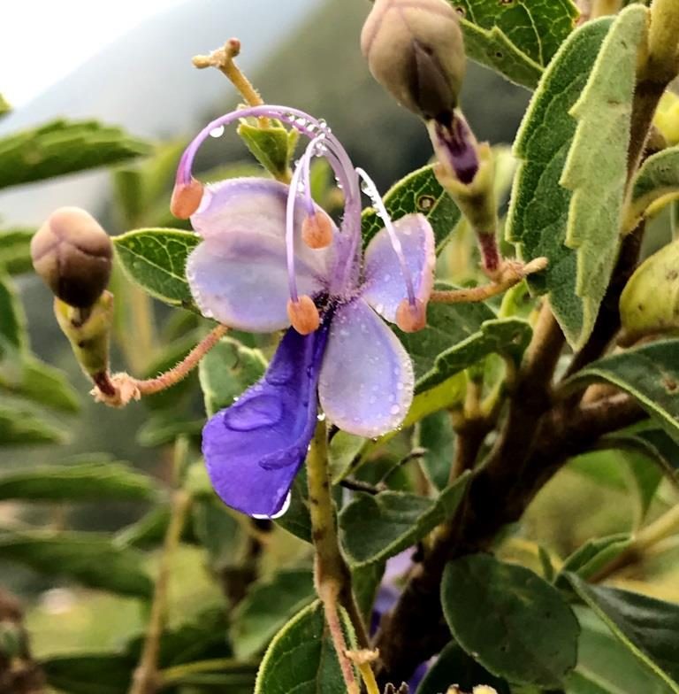
Beautiful purple flower
There were also some smaller shrubs with yellow composite flowers. I haven’t been able to identify either of these flowers, though I presume that they are native to the region.
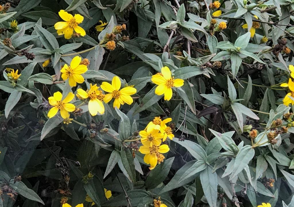
Yellow composite flowers
This second entrance gate was on a side road to the main road; the main road continues roughly northwest to Serengeti National Park. I was sporadic about having my GPS turned on, so I have only a partial GPS track of the visit within the Conservation Area, shown here. In this image – click on it to enlarge – the caret at the south end of the red track, recorded on the way out, is the first entrance gate. From here we drove northwest, past the village of Ngorongoro and along the yellow road, picking up the purple track where I turned my GPS on. The second entrance gate is where the purple track leaves the yellow road and enters the Ngorongoro Crater. We continued the descent to the crater floor, drove around, and stopped for lunch at the picnic area located at the end of the purple track, denoted by the caret. Then we continued on the red track, eventually climbing out of the crater and exiting at the same gate where we had entered (first gate, above). After exiting the Conservation Area we returned to Moshi, a 4-hour drive.

GPS track for visit to Ngorongoro Conservation Area
This is an example of what the crater floor looked like. Much of it is grassland with relatively short grass and few trees. The nearly 2,000 foot high crater wall is always visible and contrasts with the flat crater floor.

Ngorongoro Crater floor
Once we reached the crater floor my guide stopped our vehicle and deployed the pop-top. (It wasn’t safe to drive down the crater wall with the top up, since that tended to encourage passengers to stand up for better views!) As we drive along we began to see various animals, as described in the next post. At one point we had an amazing 20-minute viewing opportunity for a pair of lions. While we enjoyed that I noticed a purple flower just outside our vehicle, so I took pictures without exiting the vehicle. Needless to say, it is prohibited to exit the vehicles outside the officially designated picnic area. I believe the flower is Gutenbergia cordifolia, which does not have a common/English name.
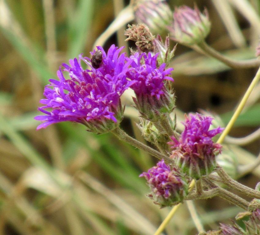
Purple flower, likely Gutenbergia cordifolia
After we resumed our drive we passed several unusual plants. First I noticed some striking ball-shaped structures, some covered in white strands; the ball-shaped structures turned out to be seed pods, shown in the left view. On the right is a view of blossoms of the same plant. The blossoms look like milkweed blossoms – because they are! This is a balloon plant (Gomphocarpus physocarpus). The genus, whose name means ”club fruit”, is widespread across Africa, whereas “traditional” milkweeds are in a closely related genus within the same taxonomic subfamily.

Balloon plant: seed pod (left) and blossoms (right)
As we continued driving I began to notice plants with rather small, bright pink-red flowers. When I asked my guide about them he stopped where I could get a good view and told me they were hibiscus. In general, fancy reproductive parts are a characteristic of hibiscus flowers, but a breeze ensured that the plants were blowing around such that I didn’t have a view of the front of any of the blossoms. I later confirmed that Hibiscus aponeurus is found in the region in dry, open grassland.
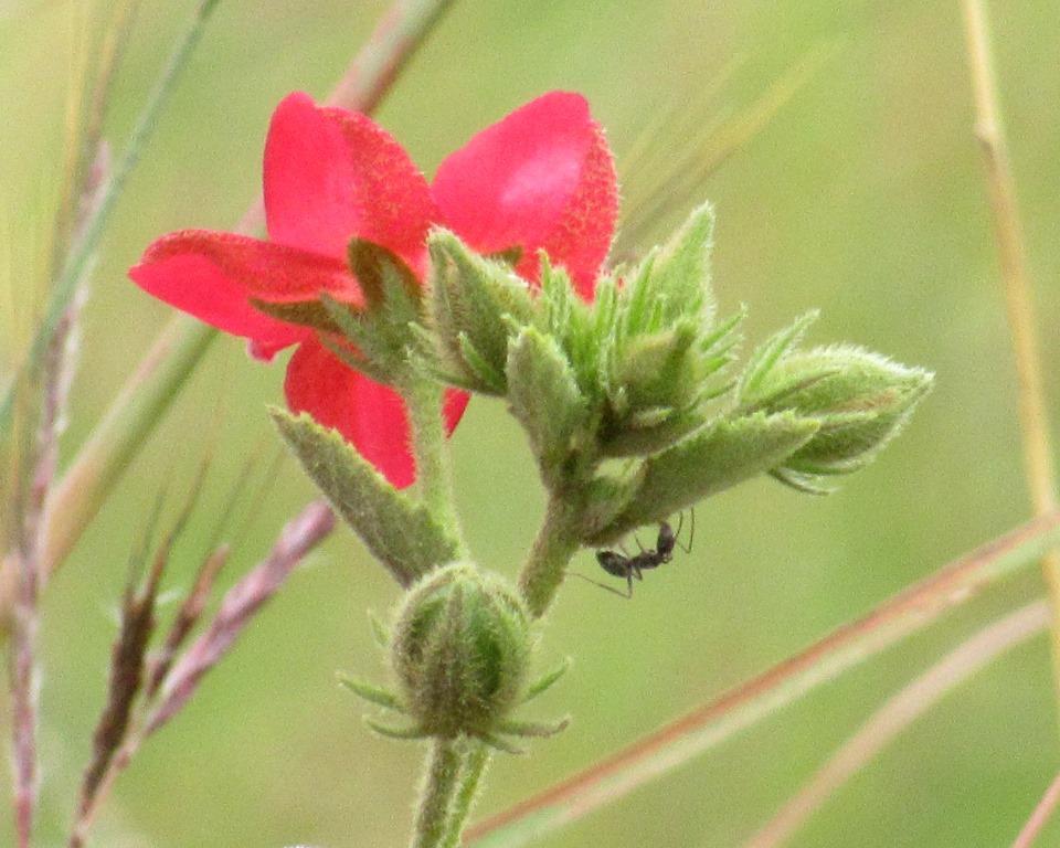
Bright pink-red hibiscus
The next flowering plant we found was a bit of a surprise to me, because the blossom looks very similar to a flower I often see locally and that is native to California. But it turns out that the genus, Solanum, is very large and diverse, with as many as 2,000 species including major food crops like tomato, potato, and eggplant, as well as (poisonous) nightshades and ornamental plants. In any case, this plant is sometimes known as Sodom apple (Solanum campylacanthum), though I note that at least one other similar plant is also known by the same common name. I took a few pictures of the fruits, which look like small green apples and give rise to the common name, but I didn’t manage to get one in focus.

Sodom apple, a nightshade
After nearly 4 hours exploring the crater floor we arrived at the official picnic area, where safari vehicles congregated and passengers could get out and walk around, use a restroom, and have a box lunch. The picnic area was next to a small body of water, likely quite shallow due to the flatness of the crater floor. I’m pretty sure it is the Sangor Swamp, which receives its water from nearby Ngoitokitok Springs. The view from the parking area was quite pretty.

Picnic area in Ngorongoro Crater
After a leisurely lunch break we continued our drive, heading generally toward a road that exits up the crater wall. On the way we passed fairly close to the edge of the lake that is visible as a white area in the Google Earth image. Lake Magadi is a year-round alkaline lake, again rather shallow. Magadi is the Swahili word for salt.
Once again, the crater wall was always within view from the crater floor. In this view there were scattered clouds, some not too far above the elevation of the rim of the crater. So the clouds had lifted a bit since the morning, but had not entirely dissipated.

Grassland and crater wall viewed from within Ngorongoro Crater
Shortly before we began the nearly 2,000-foot climb out of Ngorongoro Crater we found another shrub, this time with yellow flowers, which turned out to be a bush mallow (Abutilon mauritianum).
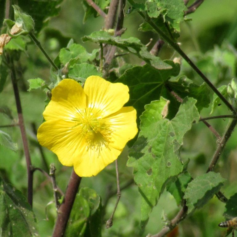
Bush mallow
A few minutes later we began to climb out of the crater. My GPS data indicates that the grade was about 8.5%, which is fairly steep, though not unprecedented, for a road. Along the way there were some nice views. This picture was taken near the beginning of the climb, I think when my guide slowed down considerably to negotiate a tight turn.

View into Ngorongoro Crater from the exit road
It was kind of a final view into the beautiful Ngorongoro Crater. When we reached the crater rim we also came to the same road we’d entered on in the morning. We reversed our route to the Conservation Area exit gate and then drove back to Moshi, completing a very memorable 2-day safari. As mentioned earlier, there will be two more posts about my visit to Ngorongoro Conservation Area: one focusing on wildlife and one focused on birds.

Pingback: Safari visit to Ngorongoro Conservation Area: animals | trailhiker
Pingback: Safari visit to Ngorongoro Conservation Area: birds | trailhiker
Pingback: Tanzanian 2-day safari overview and travel | trailhiker
Pingback: Safari visit to Tarangire National Park | trailhiker
Pingback: Safari visit to Tarangire National Park: birding | trailhiker