Article

Quaternary Lowstand Prograding Wedges of the Salento Continental Shelf (Southern Adriatic Sea, Italy): Architectural Stacking Patterns and the Control of Glacio-Eustatic Sea Level Fluctuations and Foreland Tectonic Uplift

Istituto di Scienze Marine (ISMAR), Consiglio Nazionale delle Ricerche (CNR), Sezione Secondaria di Napoli, 80133 Napoli, Italy
Geosciences 2023, 13(1), 4; https://doi.org/10.3390/geosciences13010004
Submission received: 9 November 2022 / Revised: 16 December 2022 / Accepted: 19 December 2022 / Published: 22 December 2022

Abstract

:
The performance of both the tectonic uplift and of the 4th-order glacial eustatic sea level fluctuations in controlling the stratigraphic architecture of Quaternary lowstand prograding wedges of the Salento continental shelf (Southern Adriatic sea, Italy) during a time interval spanning from the Middle Pleistocene to the Holocene has been pointed out through the interpretation of high-resolution seismic reflection profiles and their correlation to the curves of the isotopic stratigraphy. Three main transgressive surfaces of erosion (RS1, RS2 and RS3) punctuate the stratigraphic architecture of the Salento continental shelf, separating Quaternary lowstand prograding wedges between them. All along the Middle Pleistocene, increasing the tectonic uplift of the Puglia offshore, combining with 4th-order glacio-eustatic variations, have dealt with the pattern of a broad forced regression prograding wedge, favoring a platform progradation of approximately 15 km. The architectural stacking patterns of the overlying Late Pleistocene and Holocene prograding wedges are controlled by 4th-order glacio-eustatic sea level changes, allowing for the formation of incomplete depositional sequences. In this period, the eustatic signature overcomes the tectonic mark, implying a decline in the uplift of the Apulian foreland in the course of the final 250 ky.

1. Introduction

The study of the interplay of tectonic uplift and eustatic sea level changes suggests that the influence of tectonics is mild, so that it only interacts with, but does not completely destroy, the effects of eustasy recorded in sediments deposited during the “quiet” period preceding the tectonic perturbation. Sequence stratigraphic concepts and related applications have been deeply improved in recent years, enabling construction of an up-to-date framework of sequence stratigraphic concepts [1,2,3,4,5,6,7]. Catuneanu [1] has outlined a standardized workflow of stratigraphic analysis, due to the tendency of sequence stratigraphy towards an overall standardization, reflecting the definition of model-independent concepts and units. The genetic units of the sequence stratigraphic framework are the result of the interaction between the accommodation and the sedimentation, and include forced regressive, lowstand and highstand normal regressive and transgressive units, which are bounded by sequence stratigraphic surfaces [1,2]. Zecchin and Catuneanu [3] have studied the high-resolution sequence stratigraphy of clastic shelves, focusing on the units and on the bounding surfaces, highlighting the differences existing between the outcrop and the seismic scale. In particular, the outcrop resolution of the stratigraphic surfaces has offered more opportunities to recognize the corresponding stratigraphic surfaces. Several types of stratigraphic units have been defined, starting from the architectural units, bounded by stratigraphic surfaces, to the system tracts and sequences [3]. Zecchin [4] has proposed abandoning the concept of parasequence. The inconsistencies in the parasequence definition and the confusion generated by its usage have suggested that this term should be avoided. This is not a simple problem of terminology, as the parasequence definition is referred to as a precise architecture and implies particular generating processes. The concept of parasequence is considered out of date and is replaced by the concept of high-resolution sequences [4].
Melehan et al. [5] have studied the sedimentology and the stratigraphy of the Upper Permian succession of the Northern Sidney Basin, located in Australia, applying the revised sequence stratigraphic concepts. The sequence-stratigraphic development of the depositional environments and sub-environments in this basin has shown progradation and aggradation of the deltaic system and subsequent erosion by fluvial action. These features have suggested a forestepping and upstepping shoreline trajectory, which defines normal regression. Coarsening and thickening upward cycles at the lower stratigraphic levels have been identified in the prodelta and delta-front deposits. These cycles are interpreted as higher-frequency cycles, answering to small-amplitude, short-term fluctuations. Maravelis et al. [7] have focused on the interplay between tectonics and eustasy in the same basin. The stratigraphic architecture has shown a complete depositional sequence, controlled by tectonically induced subsidence, but also influenced by the high sedimentation rates and by the inherited topography. Eustatic sea level fluctuations were geological factors of less importance during the sequence deposition.
The Salento continental shelf (Southern Adriatic sea, Italy) meets very well the above requirements. Situated far from the effects of orogeny-related tectonics, the thick prograding wedges constituting the bulk of the platform [8,9,10,11] sensitively record the high-frequency eustatic oscillations during the last 400 ky [11,12,13,14,15,16,17,18,19,20,21,22,23]. The inspected district displays a compound building of Pleistocene prograding wedges, indicating the issues of the give and take of sediment accretion, glacio-eustatic sea level reversals [23,24,25,26,27] and tectonic uplift catching the Apulian foreland as the Pleistocene [28,29,30,31,32,33,34,35,36,37,38,39,40,41,42,43,44].
The bulk of the continental shelves in the Mediterranean region is often formed by lowstand and forced regressive system tract deposits more than by transgressive and highstand deposits based on high-resolution seismo-stratigraphic studies [38,40,45,46,47,48,49,50,51,52,53,54,55,56,57,58,59,60,61,62]. On the Mediterranean margins, the development of the forced regression and lowstand system tract deposits is prevalent within the Quaternary stratigraphic sequences. This is due to the strong influence on the stratigraphic architecture by high-amplitude and high-frequency glacio-eustatic signal, which is distinguished from rapid sea level rises, short highstand phases and long-term and gradual sea level falls. Forced regressive and lowstand system tract deposits are predominant in the stratigraphic sequences of the Mediterranean continental margins, which have undergone a low rate of subsidence.
The lowstand prograding wedges of the Adriatic continental margin and of the Po Plain and adjacent offshore have been deeply investigated based on previous marine geological studies [40,63,64,65,66,67,68,69,70]. The occurrence of eustatic and tectonic control factors has influenced the geological framework of the Quaternary regressive sequences of the Adriatic Basin [40,71]. Four depositional sequences have been recognized and correlated to a regional scale in the central and southern Adriatic Sea. In particular, each depositional sequence has shown a predominance of the regressive deposits, while the transgressive deposits are lacking or very reduced in thickness [40]. The chronostratigraphic reconstruction has suggested that each sequence can be the result of 4th-order cycles, lasting approximately 120 kyr. These results are consistent with the general stratigraphic architecture of the Mediterranean continental margins during the Late Quaternary, which has evidenced that 4th- and 5th-order glacio-eustatic cycles have acted as main control factors on continental shelves [46,47,53,54,55,56,57]. Ridente and Trincardi [71] have studied the Quaternary regressive sequences of the Adriatic basin based on marine geological data. Four regressive sequences on the western continental shelf of the Adriatic basin have been controlled by the sea level fluctuations related to glacio-eustatic cycles. The four sequences are bounded by erosional surfaces that formed during sea level fall, subaerial exposure of the shelf and subsequent sea level rise and erosional reworking.
In the Southern Adriatic Sea, the growth of the delta and of the river valleys has been deeply investigated as controlled by both climatic and eustatic variations [66]. In particular, the Manfredonia Valley has displayed multiple progradations, with four entry points of sediments located on the northern and southern side of the valley. The morphology of the Manfredonia Valley has been suggested as one of the best preserved valley fills in the Mediterranean area and seems to reflect the pre-LGM (Last Glacial Maximum) morphology [40,72,73]. Rapid and episodic sea level rises have been documented on the Adriatic continental shelf after the LGM. The LGM occurred as a subaerial exposure of the northern sector of the Adriatic Sea, which was incised by a drainage network terminating with lowstand delta deposits located at the northern margin of the Middle Adriatic depression [40]. In the Manfredonia Gulf, De Santis and Caldara [72] have recognized a buried surface, on which three incised valleys are located. Beneath this surface, a pre-upper Würm seismic unit (PW) was identified, and above, the transgressive system tract (TST) and highstand system tract have been recognized. These units and their boundaries were dated and correlated with phases of the last glacial–interglacial cycle. The incised valley system was attributed to the Marine Isotopic Stage (MIS) 2. The TST and HST units fill the valleys and were attributed to the post-glacial sea level rise and highstand. Maselli and Trincardi [73] showed that the Manfredonia Incised Valley (MIV) was controlled by an unique phase of incision, triggered by the last glacial–interglacial sea level fall that forced the drainage network of the Tavoliere Plain to shift basinwards, reaching its maximum width at the peak of the Last Glacial Maximum (LGM). The Manfredonia Incised Valley was filled during a time of approximately 10,000 yr of the Late Pleistocene–Holocene sea level rise.
The aim of this paper is to give a framework of the stratigraphic and tectonic architecture of the eastern Salento continental shelf based on the interpretation of high-resolution seismic reflection profiles collected onboard of the R/V Urania during the oceanographic cruise GMS94-01 [8]. This issue has been already investigated in detail in previous papers [9,10]; it will be briefly resumed in further sections on the seismic stratigraphy of Pleistocene prograding wedges. In this paper, the performance of both the Apulian foreland uplift and of the Pleistocene glacio-eustatic sea level phases in governing the deposition of complex, superimposed prograding wedges and the formation of transgressive surfaces of erosion (ravinement surfaces) [51] bounding the lowstand wedges at their top and at their base will be clarified. Moreover, the ravinement surfaces recognized in this paper may be compared con similar surfaces (ES1, ES2) recognized and discussed by Rovere et al. [74] in the Southern Adriatic Sea. The sedimentary succession of the western Adriatic margin has been age constrained based on the calibration of seismic stratigraphy with a set of multi-proxy chronological data derived from sediment cores and borehole data [74]. In particular, last postglacial deposits are bounded by Erosional Surface 1 (ES1), while Erosional Surface 2 (ES2) records sea level rise from Isotope Stage 6 to Stage 5 [74].

2. Geological Setting

The Apulian region, located in the Southern Adriatic area represents an extensive foreland domain related to the Apenninic fold and thrust belt (Apulian foreland). It consists of an emerged area [30,75,76] and of a submerged area. The Salento continental shelf is part of the Apulian foreland, which corresponds to a wide antiformal structure, WNW-ESE trending, block-faulted and variably uplifted during the Late Neogene (Figure 1) [30,75,76].
Transfer faults, striking oblique or perpendicular to the main antiformal structure, segmented the Puglia region in three main blocks (Gargano, Murge and Salento; Figure 1), that show different rates of uplift during the Plio-Pleistocene, when the Central Adriatic Sea underwent high subsidence rates, interpreted as the effect of the eastwards rollback of the hinge of the west-dipping Apenninic subduction [30].
The Apulian area shows a uniform structure with a basement formed by continental crust overlain by a thick sedimentary cover (mainly Mesozoic carbonates) overlain by thin Cenozoic carbonate-terrigenous deposits [76]. The Jurassic-Cretaceous carbonate succession shows typical facies of a slowly subsiding carbonate platform (Apulian carbonate platform). The bulk of the Murge-Gargano sector is built up of cyclic shallow water carbonates of back-reef lagoon facies spanning a time interval from Early to Late Cretaceous.
The lower part of the inner platform carbonate sequence (“Calcare di Bari” Formation, Valanginian to Cenomanian in age) extensively crops out in the north-western Murge sector for a thickness of approximately 2000 m and is built up of regularly bedded fossiliferous limestones and dolomitic limestones [77].
The upper part of the same sequence (“Calcare di Altamura” Formation, Santonian to Maastrichtian in age) is well exposed in the south-eastern Murge and Salento sectors for a thickness of 1000–1500 m and is formed by regularly stratified fossiliferous limestones [77].
For the time interval from the Late Jurassic to the Late Cretaceous the existence of a platform-to-basin transition is shown by platform margin, slope and pelagic facies cropping out in the eastern part of the Gargano Promontory.
Continuation of this platform-to-basin system, buried by Tertiary clastics and corresponding to the actual edge of the Apulian carbonate platform was observed in offshore seismic sections [31,77,78,79,80].
The present margin corresponds to an erosional escarpment that developed in consequence of an Early Tertiary erosional retreat of the Mesozoic carbonate platform margin, probably related to the subsidence of the South Adriatic Basin.

3. Materials and Methods

The Sparker seismic profiles (Sparker 1 kJ seismic source) have been acquired in 1994, during the GMS94-01 oceanographic cruise, carried out by the CNR ISMAR of Naples, Italy, on the R/V Urania [8,9,10] (Figure 2).
The study area is located on the continental platform of the southern Adriatic sea, offshore of the Salento Peninsula (Figure 1).
The techniques applied in the geological interpretation of the seismic data are the seismo-stratigraphic ones, focusing in particular on the lowstand deposits and on the ravinement surfaces.
The deposits originated during the sea level lowstand of the Quaternary, corresponding to last Quaternary glacial episode (isotopic stage 2) [11,12] may be schematically subdivided from the lower part to the upper part of the stratigraphic column as deposits of mass transport, turbiditic systems of base of slope and progradational wedges of shelf margin [49,50,51].
The progress of each one depends on the morphological context and on the siliciclastic supply. The deposits of mass transport tend to have a considerable areal expansion and display chaotic horizons or acoustically transparent seismic units and erosional bottom.
Classic cases of these deposits take place in the Meso-Adriatic Depression [81] and in some peri-tyrrhenian basins [82]. Base-of-slope turbidity deposits show small depositional reliefs, channelled in their proximal piece; muddy levees are on sides of stable channels with a greater supply of fine-grained sediments. Examples of these types of lowstand deposits come from physiographically not mature continental margins in areas characterized by large sedimentary supply during the Quaternary [81,82,83].
The Adriatic basin shows examples of progradational wedges characterized by large dimensions (200 km of progradation from north to south for a thickness of 250 m) [81]. On the continental shelf margins, progradational deposits record the first phases of sea level rise, showing vertical aggradation in the top set and a progressive landward shifting of coastal onlap.
The origin of the ravinement surfaces is shown in Figure 3. They represent important stratigraphic surfaces in the depositional environments of beach and continental shelf. During the sea level rise from the position 1 to the position 2 the beach moves landwards and the process of reworking and erosion of coastal barrier deposits acts during the passage of the shoreline, giving the dismantling of a part of the barrier, leaving preserved the back-barrier facies (Figure 3). The new deposits of inner shelf are younger than the underlying back-barrier deposits. As a consequence, the barrier deposits are coeval with the shelf deposits located above the ravinement surface seawards [84].

4. Results

4.1. Glacio-Eustatic Sea Level Fluctuations and Foreland Tectonic Uplift in the Apulian Region

Several studies carried out in recent years on relative sea level changes in the Mediterranean area evidenced that they are controlled by several factors, such as eustatic changes, tectonic uplift or subsidence and glacio- and hydro-isostatic deformation during the considered period [12,13,16,17]. Lambeck et al. [17] showed that the relative sea level changes along the Italian coast, the combined result of eustasy, glacio-hydro-isostasy and tectonic uplift, exhibits a considerable spatial and temporal variability throughout the Holocene. The authors have evaluated the tectonic contribution to the relative sea level changes from the elevation of MIS (Marine Isotopic Stage) 5.5 shoreline markers, while the eustatic and the isostatic contributions have been calculated from models on ice sheets and earth rheology. Using the calibrated model parameters, the authors predicted the relative sea level change due to eustasy and the concomitant isostasy is predicted across the central Mediterranean region for the period to the Last Glacial Maximum to the present [17], also establishing the migration of shorelines for the same period. Holocene tectonic rates of vertical motion are also given for the same period.
Glacio-eustatic sea level fluctuations in the Apulian region during the Late Pleistocene-Holocene have been investigated in detail by several authors based on geomorphological, geochronological and archaeological data [24,25,26,27]. Based on these papers, the application of such methodologies do not allow the estimation of precise sea level changes during the second half of the Holocene, mainly because of the lack of good indicators of past sea levels. A better definition of the post-glacial maximum sea level rise was possible due to the occurrence of beach rocks and sediments marking the maximum position of the sea level during the Holocene transgression [26]. During the last glacial lowstand sea level rose quickly until approximately 7000 years B.P. reaching the maximum position at approximately 0.5 m above the present one and allowing the formation of beach dunes. The sea level dropped up to approximately 2.5 m below the present position at approximately 3500 y. B.P., allowing the formation of new beach dunes; from the Bronze Age, the sea level rose to the present position with a minimum rate of 0.7 mm/year [26].
Vacchi et al. [85] have reviewed a large amount of relative sea level (RSL) data points, resulting in a database of the Holocene sea level of the whole western Mediterranean region, including Spain, France, Italy, Slovenia, Croatia, Malta and Tunisia. The geological RSL data points included the modern taxa assemblages in Mediterranean lagoons, the beach rock characteristics and the modern distribution of Mediterranean fixed biological indicators. Archeological RSL data points have also been used.
The Gargano and Salento regions have been included in this database [85] (Figure 4). In the Gargano Promontory, the height of the MIS5e coastline has shown a moderate uplift, while a tectonic stability to weak subsidence has reported for the Salento region. As a general rule, in the western Mediterranean, the relative sea level rose continuously during the Holocene, with an abrupt lowering at 7.5 ky B.P. and a deceleration during the last ~ 4.0 ka BP [85].
In the Gargano region, the geological history of the relative sea level has been reconstructed from the Middle to the Late Holocene [78] (Figure 4). The relative sea level was above −14 m at ~7.7 ky B.P., ~−6.0 m at ~6.8 ka B.P., while at ~4.4 ky B.P., the RSL was at −2.2 ± 1.0 m [85] (Figure 4).
In the Salento region, the geological history of the relative sea level also spans from the Middle to the Late Holocene [85] (Figure 4). At ~5.5 ka BP, the RSL was at −4.0 ± 0.5 m. Then, the RSL rose to −3.4 ± 0.5 m at ~5.5 ka BP ~4.0 ka BP. Between ~4.0 and ~3.0 ka BP, the RSL remained below ~−2.5 m. At ~2.0 ka BP, one intercalated index point places the RSL at −2.2 ± 0.7 m. The RSL was still at −1.6 ± 1.0 m at 802 ~1.0 ka B.P. [78] (Figure 4).
Several investigations on rates of tectonic uplift in Southern Italy and in particular in the Apulian foreland during the Pleistocene have been carried out [28,29,30,33,34,36,38,86,87]. In particular, the areal distribution of the uplift rate values calculated for some Eutyrrhenian deposits of Southern Italy has been studied by Cosentino and Gliozzi [28]. The values of the uplift rate showed an homogeneous distribution with significant differences in several areas, matching with crustal sectors with different geodynamic behaviour during the Neogene evolution of the African and Adriatic verging orogenic systems. These sectors are represented from the coastal sectors of the Southern Apenninic chain, the Calabro-Peloritan Arc, the foreland sectors of the Apulian and Iblean zones and the Bradanic foredeep. Uplift rates evaluated for Eutyrrhenian deposits cropping out in the several areas of the Salento Peninsula (Gallipoli, Torre S. Giovanni and Grotta Romanelli) range approximately 0.23 m/ky, starting approximately 125 ky B.P. These rates have been calculated taking into account the height of the outcrops of the Eutyrrhenian deposits above the sea level, the global eustatic sea level of + 6 m during the isotopic stage 5e, correlated to the Eutyrrhenian deposits and the absolute dating of 125 ky referred to the isotopic stage 5e. De Santis et al. [86] have refined the knowledge on the terrace phases and uplift history for the Apulian foreland, applying the synchronous correlation method to reconstruct the chronology of a poorly constrained sequence of raised palaeo-shorelines. These authors have recognized palaeoshorelines in the field belonging to the following highstands: 120 ky BP (MIS 5.5, second peak), 127 ky BP (MIS 5.5, first peak), 212 ky BP (MIS 7.3), 330 ky BP (MIS 9.3), 410 (MIS 11), 525 ky BP (MIS 13.3), and 590 ky BP (MIS 15). The obtained results show field observations of the reoccupation effect of younger palaeoshorelines over older ones, due to the relatively slow uplift rates measured in the Apulian foreland. Hearty and Dai Pra [87] have identified five stratigraphic complexes that coincide with statistically unique aminozones (Aminozone A = Complex I; C = II, E = III, F = IV, and G = V). As expected, the highest resolution of ages and events is during the Holocene, where numerous soil and eolianite couplets compose the majority of the interglacial complex. In Puglia, substages of the last interglacial period (s.l.) are easily resolved by bounding Aminozones C and E.
Westaway [88] has studied the Quaternary uplift of Southern Italy, particularly in Calabria based on original fieldwork and reinterpretation of the literature, asserting that uplift along the Tyrrhenian coast of Southern Italy was mainly related to local footwall uplift related to extension of the Tyrrhenian sea. On the contrary, the author evaluated several factors controlling the uplift rates of Southern Italy, as the sea level variations during the last glacial cycle, compared to oxygen isotope calibrations [11] and the location of Eutyrrhenian wavecut platforms and marine terraces in Southern Italy. As well known, in Italy the 130 ky highstand is called the Eutyrrhenian and its terraces contain distinctive fossils of Strombus bubonius. This event, in the MIS 5e is also called the Riss-Wurm interglacial. The author investigated also the case history of Quaternary uplift of the northeastern shore of the Gulf of Taranto. The uplift of dated terraces against age has shown rates of 0.2 mm/year, with slightly higher values in the west. Data interpretation suggests that the 50 m and 80 m platforms formed during the 360 ka and 460 ka marine highstands, while the 140 m platform is consistent with uplift lasting 700 ky.
Doglioni et al. [30] have evidenced that during the Plio-Pleistocene the central Adriatic underwent high subsidence rates due to the eastward rollback of the hinge of the west-dipping Apenninic subduction. In contrast to the Central Adriatic, the Puglia region and the Bradanic foredeep underwent uplift since the Middle Pleistocene. These differences are interpreted as being due to the larger subduction hinge rollback rate since Middle Pleistocene of the central Adriatic lithosphere with respect to the thicker Puglia lithosphere. The different thicknesses appear to have controlled the variable degree of flexure of the lithosphere and its astenospheric penetration rate. The consequent different dip of the subductions in the two sections (steeper west of Puglia) could also explain the lower elevation of the Southern Apennines compared to their central-northern sector.
Mastronuzzi et al. [27] have pointed out as, taking into account an average eustatic elevation of 6 m above present sea level and an age of 125 ky for the Tyrrhenian (substage 5e) sea level highstand, a decreasing uplift rate occurred from north-west to south-east along the Ionian side in the Puglia region [33]. Uplift rates have been estimated as ranging from 0.31 m/ky in the north-west of Taranto to 0.18 m/ky in the surrounding of Taranto and to the south-west, to 11 m/ky at Torre Colimena and to –0.03 m/ky at Torre Castiglione, to 0.03 m/ky at Gallipoli and to 0.02 m/ky at Torre S. Giovanni [27]. Moreover, the authors evidenced as uplift rates along the eastern side of Puglia region are more difficult to calculate because of the lacking of the Senegalensis fauna during the last interglacial. Uplift rates have been evaluated based on the data collected at the Grotta Romanelli cave, where a notch and an abrasion platform covered by a coarse marine deposits are placed between 8–10 m above the present sea level.

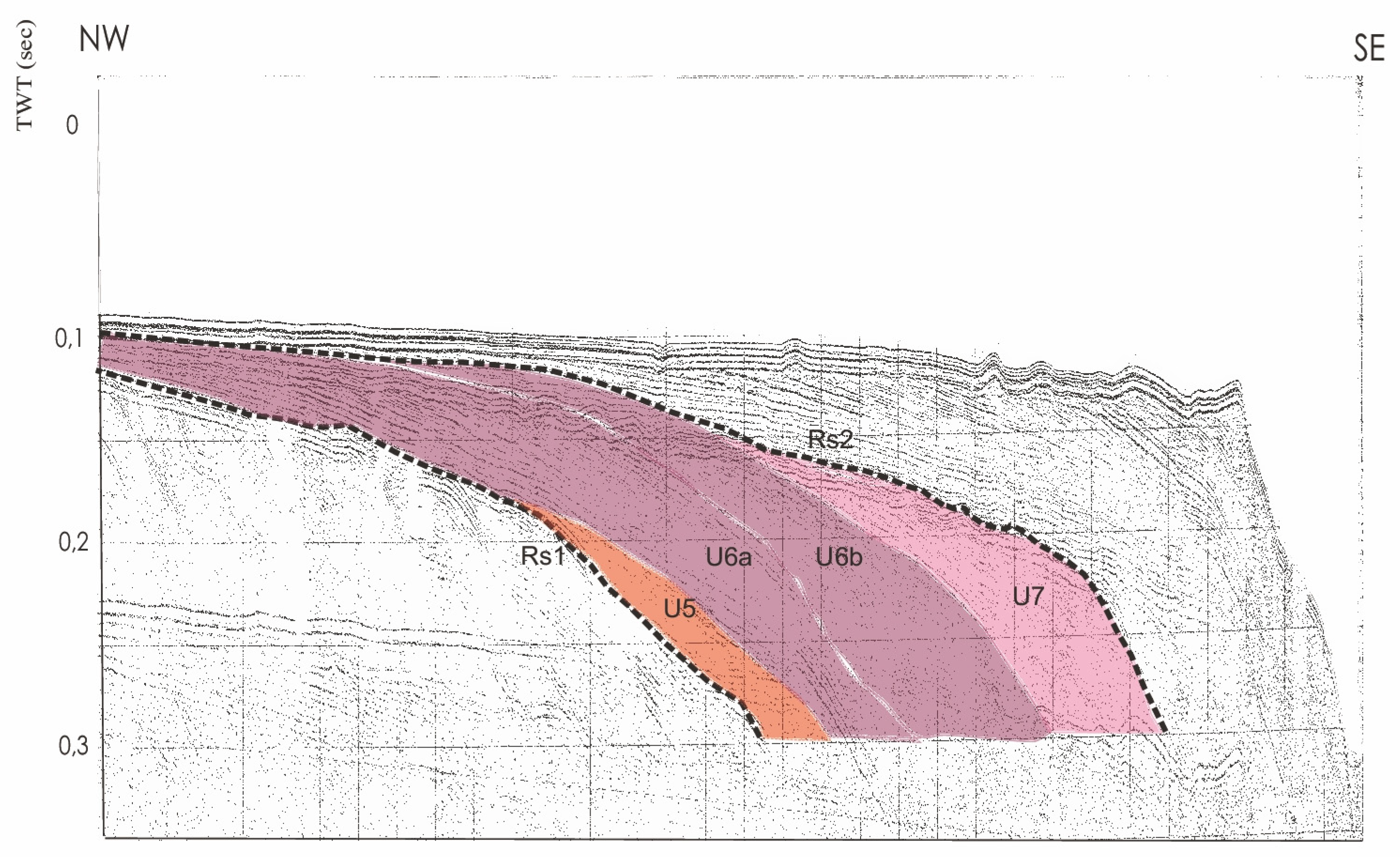
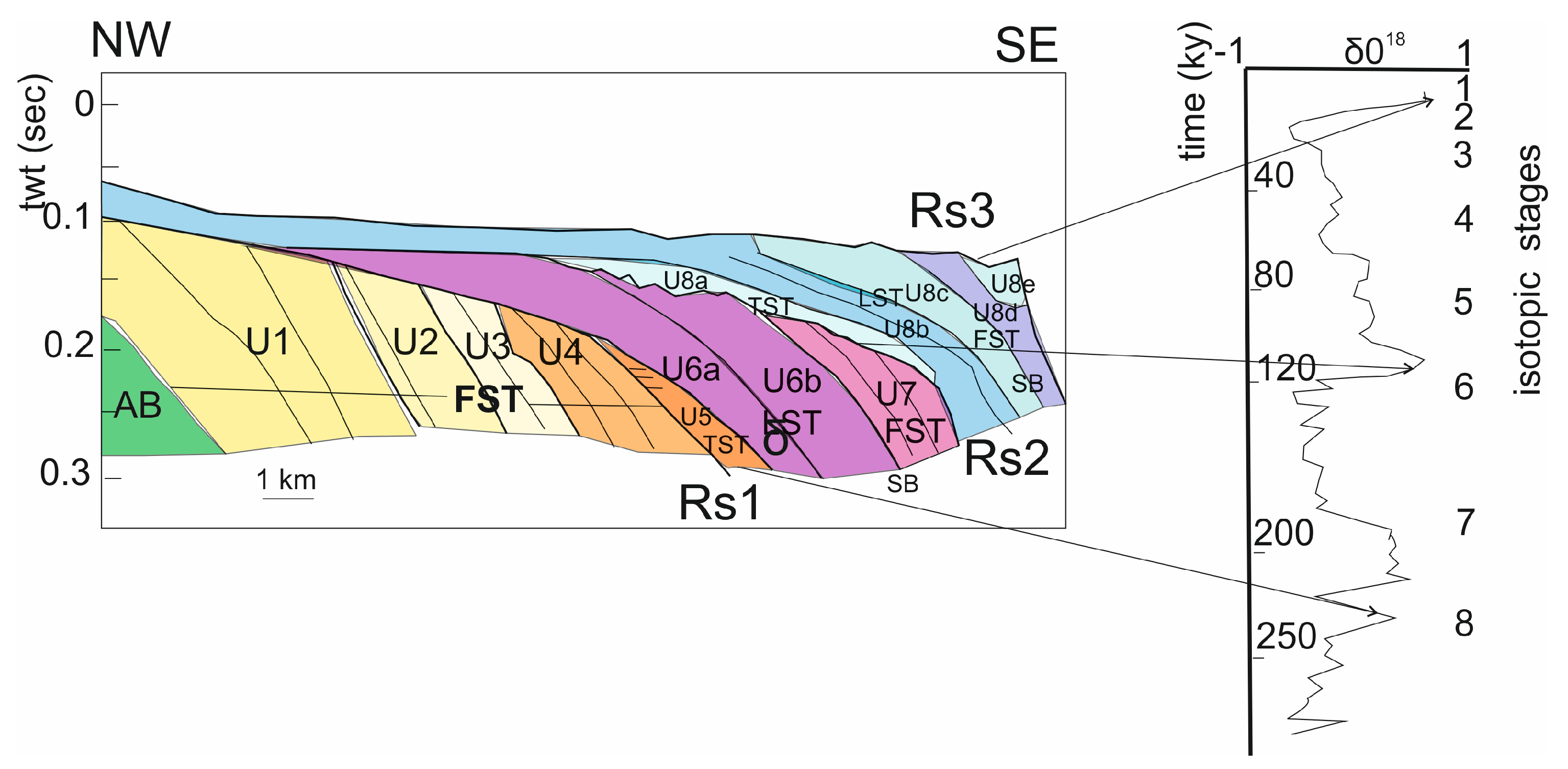
4.2. Architectural Stacking Patterns of Quaternary Lowstand Prograding Wedges

In the study area, several unconformities occur, which summarize its geological progress [9,10]. These unconformities result from regional erosional issues and, on the basis of their extent, are correlated along the whole Salento offshore. Seismic profiles have been revised and re-interpreted aimed at constructing a new Wheeler diagram of the area, supplementing further stratigraphic interpretation and correlation with the curves of the isotopic stratigraphy.
The seismic interpretation of single-channel seismic reflection profiles has allowed to investigate the seismo-stratigraphic setting, characterized by three prograding wedges separated by regional unconformities interpreted as transgressive surfaces of erosion (Figure 5). The platform progradation during the time interval spanning from the Middle Pleistocene to recent times has been evaluated in the order of approximately fifteen kilometers. The progradational geometries are well evident along a NW–SE direction (line LC9) and less along the crossing line LC1-2, where they appear as stratigraphic relationships of paraconformity between seismic reflectors. On the contrary, large antiformal and synformal structures, whose axis are NW–SE oriented, appear mainly along a N–S direction (line LC1-2). For a detailed description of the seismic units and of the corresponding depositional geometries, we can refer to Budillon and Aiello [9] and to Aiello and Budillon [10].
A scheme of the stratigraphic relationships in the Salento continental shelf has been constructed based on the interpretation of key seismic sections reported in Figure 5 (Figure 6).
The scheme describes the stratigraphic architecture of prograding wedges. In the upper cartoon we can observe three main prograding wedges, respectively composed of four (U1–U4), three (U5–U7) and five (U8a–U8e) seismic sequences. The wedges are separated by three main ravinement surfaces or transgressive surfaces of erosion, linked to significant phases of sea level rises. The unit AB represents the acoustic basement of the investigated area. In the lower cartoon we see a sketch geological section crossing perpendicularly the upper one, where synsedimentary tectonics and normal faulting involving the units U1–U4 appear well evident.
A qualitative chronostratigraphic diagram, corresponding to the scheme of stratigraphic relationships has been constructed (Figure 7) in order to give information on subaerial and/or submarine hiatuses separating the depositional sequences. The Wheeler diagram is a tool to represent time stratigraphy, and during this exercise, a qualitative chronostratigraphic correlation is carried out, further defined by the correlation with the curve of isotopic stratigraphy.
Detailed line drawings of seismic sections of the three prograding wedges are here reported in order to show architectural stacking patterns of the wedges (Figure 7, Figure 8, Figure 9 and Figure 10). Another key seismic profile (Line LC10) is interpreted in Figure 11 in order to show the stratigraphic architecture of the prograding wedges.
The first prograding wedge (W1) overlies an acoustic basement characterized by a chaotic seismic facies, bounded landwards by subaerial unconformities and showing basinwards relationships of paraconformity with the underlying wedge W1 (Figure 8). The stratigraphic architecture of W1 is characterized by four seismic units (U1 to U4) showing a progradational component more pronounced than the aggradational one. Offlap breaks of the prograding clinoforms pertaining to this wedge are not preserved because of the erosion, also if seaward shifting of prograding clinoforms is well evident. The lowest and thickest unit (unit U1) is involved by large-scale compressional deformations evidenced by antiformal and synformal structures (see also the scheme of stratigraphic relationships in Figure 7) whose axes show a NW–SE trending, perpendicular to the Apulian coastline [10]. Such deformations also involve the other units of the first prograding wedge and are cut by normal faults; they represent the seaward elongment of similar compressional structures documented on land in the Salento region [89].
The wedge W1 is interpreted as a forced regression prograding wedge [48,50,54]. W1 does not represent a complete depositional sequence, lacking of transgressive and highstand system tracts, but a lowstand prograding wedge deposited during a phase of relative stillstand of the sea level (see the following discussion). The wedge W1 is bounded upwards by an erosional unconformity, here named RS1 [9,10], interpreted as a transgressive surface of erosion. The stratigraphic architecture of the wedge W1 is also well constrained by the interpretation of the seismic profile LC 10, reported in Figure 11, where it appears as the unit is slightly deformed by normal faulting.
The architectural stacking patterns of the second prograding wedge (W2; Figure 9) appear to be different, since it starts with an onlapping unit (U5) overlying the surface RS1 and thinning laterally (along-strike) with downlap geometries. It is interpreted as a transgressive unit based on the onlap terminations on the unconformity RS1. A progradational seismic unit (U6) conformably overlies the top of the transgressive unit: it appears organized into two minor units (U6a and U6b; Figure 9). The third unit constituting the wedge W2 is a progradational unit (U7), conformably overlying the U6 seismic unit and developed only at the shelf margin; on the contrary, it misses in the inner part of the shelf, where the unit U6 is directly overlain by the erosional surface RS2 (Figure 10 and Figure 11).
The third prograding wedge (W3; Figure 10) is characterized by five seismic units, whose offlap breaks are well preserved and progressively migrate basinwards. Among them, U8a represents a transgressive unit, as evidenced by the onlap of reflectors on the erosional surface RS2.

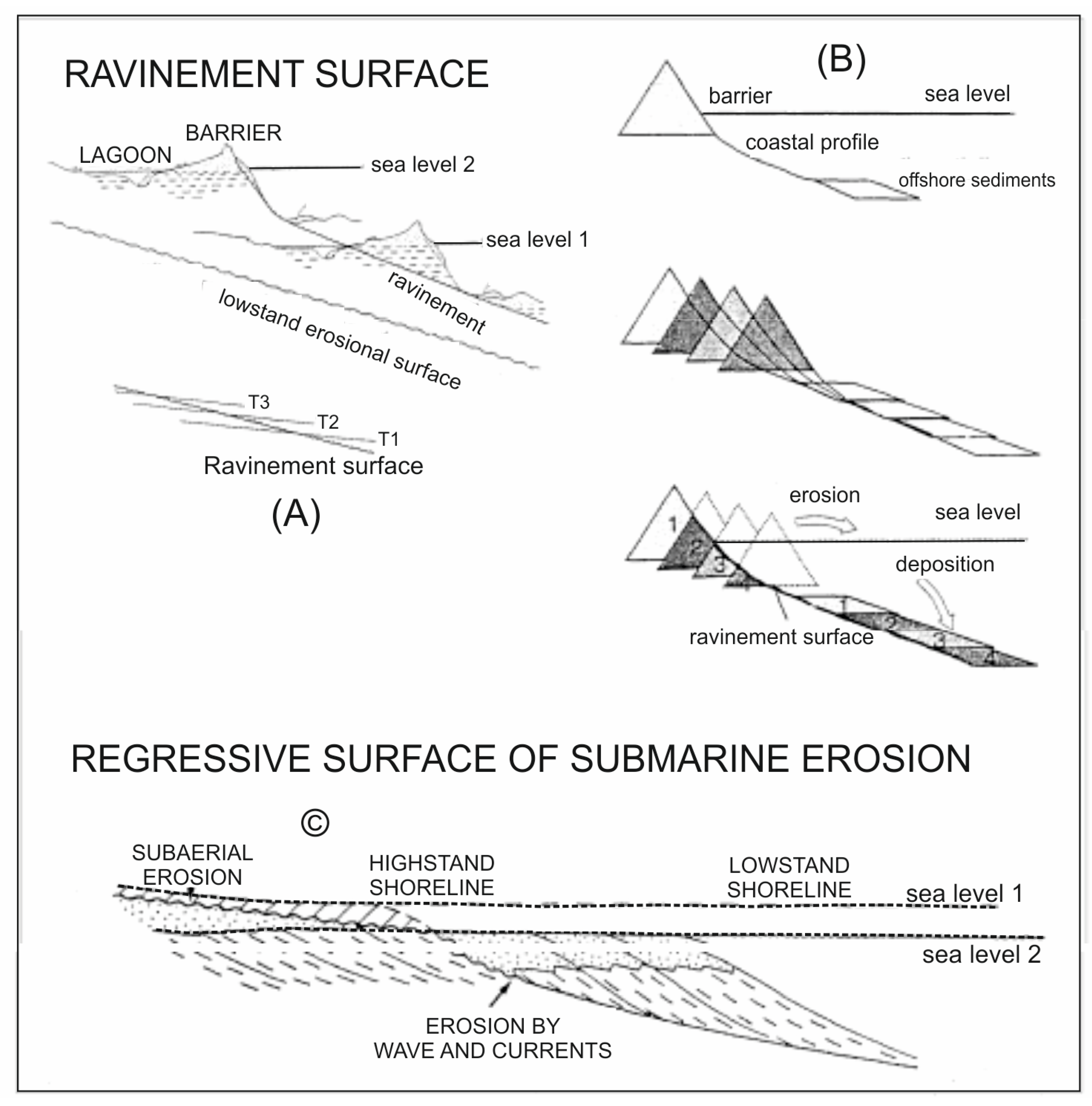
4.3. Ravinement Surfaces

The stratigraphic architecture of the prograding wedges of the Salento continental shelf is punctuated by three regional unconformities (RS1, RS2 and RS3), interpreted as transgressive surfaces of erosion or ravinement surfaces [51]. The erosional landward switch of the coastline and the reworking of the waves control their assembling.
Their gradient tends to increase from the youngest (RS3) to the oldest (RS1), as an outcome of the South Adriatic subsidence, due both to sediment filling and diagenesis [90] and regional subsidence [91].
RS1 occurs down at water depths of 180–200 m of water depth, while in the inner platform RS2 carves RS1 and is affected by compressional deformations. The forced regression prograding wedge, belonging to the seismic units U1, U2, U3 and U4 and bounded above by the RS1, has broadened the platform of more or less fifteen kilometers.
RS2 occurs down to water depths of 175–180 m and expands proceeding onshore with huger slopes than RS3. In the inner shelf and/or on structural highs, RS3 carves RS2, eroding an onlap unit (unit U5) and the overlying prograding wedge (units U6 and U7).
RS3 is horizontal and has been detected on the seabed down to a maximum depth of 120–130 m. In the inner platform, the Holocene wedge and patch-reef structures, interpreted as relicts of algal buildups, fossilize RS3. It carves the seismic unit U8.

5. Discussion

Forced regression deposits constitute the bulk of Adriatic continental platforms, both in Central and Southern Adriatic seas [9,10,40,71,81]. The stratigraphic architecture of Pleistocene continental margins in the Mediterranean region is characterized by a relative abundance of lowstand prograding wedges with respect to transgressive and highstand deposits [49,54,56,57]. Thick sedimentary wedges (“shelf-perched” lowstand wedges) [92] deposited on the outer shelf and upper slope during Pleistocene glacio-eustatic cycles. All along the Pleistocene, the glacio-eustatic sea level reversals have certainly offered highly recurrent (approximately 100 ky) fluctuations, with uneven cycles, disclosing fast rises and late falls of sea level [11,14]. More gradual and longer lasting phases of sea level fall occur, because of more continued time of ice forming compared to ice melting.
The forced regression system tract, assembled at the same time as stages of relative sea level drop, was introduced by Hunt and Tucker [48] as an alternative to the classical sequence stratigraphy model. The corresponding high-resolution sequences evolve as a reaction to the decline of relative sea level fall and are abandoned when the amount of eustatic fall grows. The location of sequence boundary with respect to the forced regression deposits is controversial, since it can be located above the forced regression deposits [48] or, alternatively, it is located at the base of the lowstand prograding wedges [54].
The wave and tidal ravinement surfaces are developed during relative sea level rise and transgression. The transgressive surface merges into the pre-existing unconformity, and the resulting sequence boundary is a polygenic regressive-transgressive surface. The unconformity used to trace the sequence boundary is thus not only formed by transgressive or simply ravinement erosion during sea level rise, but it also and mainly originated by marine regressive and subaerial erosion during sea level fall.
The ravinement surfaces and the seismic units, so individuated and described, can be considered as stratigraphic markers, notwithstanding their diachronous character, and have been correlated to the curve of the oxygen isotope stratigraphy [14].
The high-resolution stratigraphic correlation among the ravinement surfaces and the curve of oxygen isotope stratigraphy of the last glacio-eustatic course is disclosed in Figure 12 [10]. The unconformity RS3 conforms to the passage from the isotope stage 2 to 1 and is related to the last significant sea level rise (18 ky B.P.).
Therefore, the prograding wedge W3, bounded above by the ravinement surface RS3, represents a fourth-order incomplete depositional sequence, composed of a transgressive system tract (unit U8a), a lowstand system tract (units U8b–U8c) and a forced regression system tract (units U8d–U8e), both deposited during the last phases of the last pleniglacial, corresponding to the transition from the isotope stage 2 to 1 (Figure 12). The ravinement surface RS2, bounding at the base the prograding wedge W3 and at the top the prograding wedge W2 formed during a sea level rise at the transition between isotopic stages 6 and 5.
Accordingly, the prograding wedge W2 deposited during a time interval spanning from approximately 220 and 125 ky and represents a fourth-order incomplete depositional sequence composed of a transgressive system tract (unit U5), a lowstand system tract (unit U6) and a forced regression system tract (unit U7). Both the wedges W3 and W2 show a sequence boundary at the top of the lowstand system tract, corresponding to the base of the forced regression system tract (Figure 12). RS1 correlates with a sea level rise of approximately 250 ky, agreeing to the progress from isotopic stages 8 to 7 (Figure 12). W1 completed as the Middle Pleistocene, ahead 250 ky; it depicts a thick forced regression prograding wedge, built of four seismic units (U1–U4), which broadened the Salento continental shelf by approximately 15 km.
The architectural stacking patterns of Quaternary lowstand prograding wedges in the Salento continental shelf (Southern Adriatic sea, Italy) dealt with the cooperation of high-frequency glacio-eustatic fluctuations and foreland tectonic uplift. All along the Middle Pleistocene, 4th-order oscillation related to brief eccentricity rhythms handled the formation of forced regression system tracts [10]. Regional geological evidence advises high tectonic uplift in the Apulian foreland at that time [28,29,30]. Such uplift prevailed over the glacio-eustatic variation during the same time interval, producing a relative sea level decline, governing the deposition of the prograding wedge W1. Such a hypothesis is also constrained by the lack of siliciclastic supply due to fluvial systems onshore of the investigated area during the same time interval; we suppose that the high siliciclastic supply feeding the prograding wedge W1 was controlled by high rates tectonic uplift in the Apulian foreland during the Middle Pleistocene [28,29,30,33]. Moreover, synsedimentary tectonics affecting the prograding wedge W1 is well evident by the interpretation of seismic profiles, as evidenced by antiformal and synformal structures involving the units U1–U4 and growth structures in seismic sequences. Such compressional deformations have been correlated with Middle Pleistocene compressional trends documented on land in the Salento region [89]. This endorses that W1 puts in place in the course of the Middle Pleistocene.
Eustatic control prevailed in controlling the formation of Late Pleistocene and Holocene prograding wedges W2 and W3, as also inferred by the correlation with the curves of isotopic stratigraphy (Figure 12). A fourth-order cyclicity forced by short eccentricity cycles lasting up 100 ky controlled the deposition of incomplete depositional sequences (prograding wedges W2 and W3), composed of transgressive, lowstand and forced regression system tracts (Figure 12) related to oxygen isotope stages from 7/8 to 2 [14].

6. Conclusions

-
The Salento continental shelf represents a relatively undeformed area of the Apulian foreland, where the stratigraphic architecture of thick prograding wedges can be easily investigated based on the criteria of seismic and sequence stratigraphy due to the preservation of seismic sequences and original depositional geometries.
-
Three thick prograding wedges (W1, W2 and W3) whose stratigraphic architecture is punctuated by three regional unconformities interpreted as transgressive surfaces of erosion or ravinement surfaces have been recognized and correlated to the curves of isotopic stratigraphy.
-
The stratigraphic architecture of prograding wedges in the Salento continental shelf appear to be controlled by the interaction of high-frequency glacio-eustatic fluctuations with foreland tectonic uplift, as evidenced both by depositional geometries in seismic sequences and correlation with the curves of isotopic stratigraphy.
-
The huge Middle Pleistocene tectonic uplift in the Apulian foreland overcame the glacio-eustatic changes controlling the formation of a wide prograding wedge composed of four seismic units. The top of the wedge is eroded by a ravinement surface (RS1), correlating to a sea level rise of approximately 250 ky. Synsedimentary tectonics affecting the wedge also constrain the age of the wedge W1 to 250 ky based on regional geological evidence in the Salento region [89].
-
Several control mechanisms must be considered in discussing the deposition of the prograding wedge W1, having a key role in the comprehension of the stratigraphic architecture in this area. The sedimentary supply feeding this wedge is significantly rich, since it allowed a platform progradation of approximately 15 km during the Middle Pleistocene. Taking into account the absence of fluvial systems in the adjacent onshore area, such a siliciclastic supply can be have driven by high rates of tectonic uplift in the Apulian foreland during the Middle Pleistocene, as evidenced by geological and geomorphological evidence. The corrosion of coastal units and the concomitant discharge of prograding units in the adjoining offshore may have been very quick. Significant biodetritic production in the inner shelf, also evidenced by dredges carried out in the Salento offshore [8], has probably contributed to the upper slope progradation of the wedge W1. In this time interval, tectonic control prevailed over eustatic variation in controlling the stratigraphic architecture of prograding wedges.
-
Starting from 250 ky, this trend was reversed and the continental shelf deposits appear to be eustatically rather than tectonically controlled. The prograding wedges W2 and W3 are interpreted as 4th-order incomplete depositional sequences, whose stratigraphic record is exposed only at the shelf margin. The sequences are composed of transgressive, highstand and forced regression deposits; the location of the sequence boundary does not coincide with that of the ravinement surfaces, bounding the wedges at their base and top, since it is located between lowstand and forced regression deposits.
-
The deposition of the wedges W2 and W3 has been controlled by fourth-order glacio-eustasy modulated by short eccentricity rhythms [10]. A mixed nature of oscillation rhythms of relative sea level, where more protracted sea level rise merged with more abbreviated sea level falls, may be expected based on the correlation with comparable deposits detected offshore the Gargano Promontory [40].
-
The comprehensive seismo-stratigraphic setting and the stratigraphic correlation with the curves of isotopic stratigraphy advise a convincing decline in the uplift of the Apulian foreland in the last 250 ky. This conclusion is supported by the recent interesting data obtained by De Santis et al. [86,93] on the low rates of uplift in the Apulian region. New chronological constraints have been obtained by using amino acid racemization (AAR) and isoleucine/alloisoleucine epimerization (IE) on Patella spp., Thetystrombus latus (Gmelin), Glycymeris sp., and ostracods and U-series dating on corals Hoplangia durotrix Gosse and Cladocora caespitosa Linneo. This procedure has allowed for a quantitative estimate of the vertical movements and associated rates of tectonic uplift of the Apulian foreland. The palaeoshorelines in the field belonging to the following highstands 120 ky BP (MIS 5.5, second peak), 127 ky BP (MIS 5.5, first peak), 212 ky BP (MIS 7.3), 330 ky BP (MIS 9.3), 410 (MIS 11), 525 ky BP (MIS 13.3), and 590 ky BP (MIS 15) have been recognized. The obtained results show field observations of the reoccupation effect of younger palaeoshorelines over older ones due to the relatively slow uplift rates measured in the investigated area.
Chronological analyses have been used to calibrate different sea level curves and uplift rates to produce the best match between observed and expected palaeo-shorelines [86]. A first uplift rate of 0.09 mm/yr from 590 to 130 ky BP (middle Pleistocene or MIS 15-MIS 6 interval) and a second uplift rate of 0.07 mm/yr from 130 ky BP to date (Late Pleistocene or MIS 5- today) have been considered [79]. The two uplift rates are similar, assuming a constant average rate of 0.08 mm/y for all the periods (Middle Pleistocene-onwards, or interval MIS 15-onwards). Although these data show a slight slowdown in the regional uplift, an average constant uplift rate over time of 0.08 mm/yr may also be claimed to explain the regional uplift for the last 590 ka for the Apulian foreland [86].

Funding

This research received no external funding.

Data Availability Statement

Not applicable.

Conflicts of Interest

The author declares no conflict of interest.

References

  1. Catuneanu, O. Model-independent sequence stratigraphy. Earth Sci. Rev. 2019, 188, 312–388. [Google Scholar] [CrossRef]
  2. Catuneanu, O.; Zecchin, M. High-resolution sequence stratigraphy of clastic shelves II: Controls on sequence development. Mar. Pet. Geol. 2013, 39, 26–38. [Google Scholar] [CrossRef]
  3. Zecchin, M.; Catuneanu, O. High-resolution sequence stratigraphy of clastic shelves I: Units and bounding surfaces. Mar. Pet. Geol. 2013, 39, 1–25. [Google Scholar] [CrossRef]
  4. Zecchin, M. Towards the standardization of sequence stratigraphy: Is the parasequence concept to be redefined or abandoned? Earth Sci. Rev. 2010, 102, 117–119. [Google Scholar] [CrossRef]
  5. Melehan, S.; Botziolis, C.; Maravelis, A.G.; Catuneanu, O.; Ruming, K.; Holmes, E.; Collins, W.J. Sedimentology and Stratigraphy of an Upper Permian Sedimentary Succession: Northern Sydney Basin, Southeastern Australia. Geosciences 2021, 11, 273. [Google Scholar] [CrossRef]
  6. Maravelis, A.G.; Boutelier, D.; Catuneanu, O.; Seymour, K.S.; Zelilidis, A. A review of tectonics and sedimentation in a forearc setting: Hellenic Thrace Basin, North Aegean Sea and Northern Greece. Tectonophysics 2016, 674, 1–19. [Google Scholar] [CrossRef]
  7. Maravelis, A.G.; Catuneanu, O.; Nordsvan, A.; Landerberger, B.; Zelilidis, A. Interplay of tectonism and eustasy during the Early Permian icehouse: Southern Sydney Basin, southeast Australia. Geol. J. 2018, 53, 1372–1403. [Google Scholar] [CrossRef]
  8. Aiello, G.; Bravi, S.; Budillon, F.; Caruso, A.; D′Argenio, B.; De Lauro, M.; Ferraro, L.; Marsella, E.; Molisso, F.; Pelosi, N.; et al. Marine Geology of the Salento shelf (Apulia, south Italy): Preliminary results of a multidisciplinary study. Giorn. Di Geol. 1995, 57, 17–40. [Google Scholar]
  9. Budillon, F.; Aiello, G. Evoluzione pleistocenica della piattaforma continentale del Salento orientale: Fattori di controllo tettonici e/o eustatici. Il Quaternario 1999, 12, 149–160. [Google Scholar]
  10. Aiello, G.; Budillon, F. Lowstand prograding wedges as fourth-order glacio-eustatic cycles in the Pleistocene continental shelf of Apulia (Southern Italy). In Cyclostratigraphy: Approaches and Case Histories; D’Argenio, B., Fischer, A.G., Premoli Silva, I., Weissert, H., Ferreri, V., Eds.; Society for Sedimentary Geology: Tulsa, OK, USA, 2004; Volume 81, pp. 213–230. [Google Scholar]
  11. Shackleton, N.J.; Opdyke, N.D. Oxygen isotope and paleomagnetic stratigraphy of equatorial Pacific core V28-238: Oxygen isotope temperature and ice volume on a 10-year scale. Quat. Res. 1973, 3, 39–55. [Google Scholar] [CrossRef]
  12. Chappell, J.; Shackleton, N.J. Oxygen isotopes and sea level. Nature 1986, 324, 137–140. [Google Scholar] [CrossRef]
  13. Lambeck, K.; Johnston, P. Land subsidence and sea level change: Contributions from the melting of the last great ice sheets and the isostatic adjustement of the Earth. In Land Subsidence; Barends, F.B.J., Brower, F., Schroder, F., Eds.; Balkema: Rotterdam, The Netherlands, 1995; Volume 6, pp. 3–18. [Google Scholar]
  14. Martinson, D.G.; Pisias, N.G.; Hays, J.D.; Imbrie, J.; Moore, T.C.; Shackleton, J. Age dating and the orbital theory of the ice ages: Development of a high-resolution 0 to 300,000 year chronostratigraphy. Quat. Res. 1987, 27, 1–29. [Google Scholar] [CrossRef]
  15. Chappell, J. Sea level changes forced ice break out in the Last Glacial cycle: New results from coral terraces. Quat. Sci. Rev. 2002, 21, 1229–1240. [Google Scholar] [CrossRef]
  16. Lambeck, K.; Yokoyama, Y.; Purcell, T. Into and out of the last Glacial maximum: Sea level change during Oxygen Isotope Stages 3 and 2. Quat. Sci. Rev. 2002, 21, 343–360. [Google Scholar] [CrossRef]
  17. Lambeck, K.; Antonioli, F.; Purcell, T.; Silenzi, S. Sea level change along the Italian coast for the past 10,000 yrs. Quat. Sci. Rev. 2003, 23, 1567–1598. [Google Scholar] [CrossRef]
  18. Lisiecki, R.E.; Raymo, M.E. A Pliocene-Pleistocene stack of 57 globally distributed benthic δ18O records. Paleoceanography 2005, 20, PA1003. [Google Scholar] [CrossRef] [Green Version]
  19. Florindo, F.; Kamer, D.B.; Marra, F.; Renne, P.R.; Roberts, A.W.; Weaver, R. Radioisotopic age constraints for Glacial Terminations IX and VII from aggradational sections of the Tiber River delta in Rome, Italy. Earth Planet. Sci. Lett. 2007, 256, 61–80. [Google Scholar] [CrossRef]
  20. Huybers, P. Glacial variability over the last two million years: An extended depth-derived age model, continuous obliquity pacing and the Pleistocene progression. Quat. Sci. Rev. 2007, 26, 37–55. [Google Scholar] [CrossRef] [Green Version]
  21. Denton, G.H.; Anderson, R.F.; Toggweiler, J.R.; Edwards, R.L.; Schaefer, J.M.; Putnam, A.E. The Last Glacial Termination. Science 2010, 328, 1652–1656. [Google Scholar] [CrossRef] [Green Version]
  22. Konijnendijk, T.Y.M.; Ziegler, M.; Lourens, L.J. On the timing and forcing mechanisms of late Pleistocene glacial terminations: Insights from a new high-resolution benthic stable oxygen isotope record of the eastern Mediterranean. Quat. Sci. Rev. 2015, 129, 308–320. [Google Scholar] [CrossRef]
  23. Bosi, C.; Carobene, L.; Sposato, A. Il ruolo dell’eustatismo nell’evoluzione geologica dell’area mediterranea. Mem. Soc. Geol. Ital. 1996, 51, 363–382. [Google Scholar]
  24. Dini, M.; Mastronuzzi, G.; Sansò, P. The effects of relative sea level changes on coastal morphology of Southern Apulia (Italy) during the Holocene. In Geomorphology, Human Activity and Global Environmental Change; Slaymaker, O., Ed.; John Wiley and Sons: Chichester, UK, 2000; pp. 43–65. [Google Scholar]
  25. Centenaro, E.; Gianfreda, F.; Mastronuzzi, G.; Sansò, P.; Selleri, G. Pleistocene relative sea level changes and morphological evolution of Otranto-Castro coastal area (Puglia, Italy). In Proceedings of the Workshop MACRIVALIMA, Ostuni, Italy, 30–31 May 2002. [Google Scholar]
  26. Auriemma, R.; Iannone, A.; Mastronuzzi, G.; Mauz, B.; Sansò, P.; Selleri, G. Late Holocene sea level changes in Southern Apulia (Italy). In Proceedings of the Final Conference Project IGCP 437, Puglia 2003, Otranto, Italy, 22–28 September 2003. [Google Scholar]
  27. Mastronuzzi, G.; Pignatelli, C.; Sansò, P. Geological and geomorphological setting. In Proceedings of the Final Conference Project IGCP 437, Puglia 2003, Otranto, Italy, 22–28 September 2003. [Google Scholar]
  28. Cosentino, D.; Gliozzi, E. Considerazioni sulla velocità di sollevamento dei depositi eutirreniani dell′Italia meridionale e della Sicilia. Mem. Soc. Geol. Ital. 1992, 41, 653–665. [Google Scholar]
  29. Stewart, I.S.; Cundy, A.; Kershaw, S.; Firth, C. Holocene coastal uplift in the taormina area, northeastern sicily: Implications for the southern prolongation of the calabrian seismogenic belt. J. Geodyn. 1997, 24, 37–50. [Google Scholar] [CrossRef]
  30. Doglioni, C.; Mongelli, F.; Pieri, P. The Puglia uplift: An anomaly of the foreland of the Apenninic subduction due to the buckling of a thick continental lithosphere. Tectonics 1994, 13, 1309–1321. [Google Scholar] [CrossRef]
  31. Mindszenty, A.; D′Argenio, B.; Aiello, G. Lithospheric bulges at regional unconformities. The case of Mesozoic-Tertiary Apulia. Tectonophysics 1995, 252, 137–161. [Google Scholar] [CrossRef]
  32. Pieri, P.; Festa, V.; Moretti, M.; Tropeano, M. Quaternary tectonic activity of the Murge area (Apulian foreland—Southern Italy). Ann. Geofis. 1997, 60, 1395–1404. [Google Scholar] [CrossRef]
  33. Bordoni, P.; Valensise, G. Deformation of the 125 ka marine terrace in Italy: Tectonic implications. In Coastal Tectonics; Stewart, I.S., Vita-Finzi, C., Eds.; Geological Society of London, Special Publication: London, UK, 1998; Volume 146, pp. 71–110. [Google Scholar]
  34. Amato, A.; Belluomini, G.; Cinque, A.; Manolio, M.; Ravera, F. Terrazzi marini e sollevamenti tettonici quaternari lungo il margine ionico dell’Appennino lucano. Il Quaternario 1997, 10, 329–336. [Google Scholar]
  35. Ascione, A.; Cinque, A. Tectonics and erosion in the long-term relief history of the Southern Apennines. Zeitsch. Fur Geomorphol. 1999, 117 (Suppl. BD-218), 1–16. [Google Scholar]
  36. Amato, A. Estimating Pleistocene Tectonic Uplift Rates in Southeastern Apennines (Italy) from Erosional Land Surfaces and Marine Terraces. In Geomorphology, Human Activity and Global Environmental Change; Slaymaker, O., Ed.; John Wiley and Sons: Chichester, UK, 2000; pp. 67–87. [Google Scholar]
  37. Ghisetti, F.; Vezzani, L. Depth and modes of Pliocene–Pleistocene crustal extension of the Apennines (Italy). Terra Nova 1999, 11, 67–72. [Google Scholar] [CrossRef]
  38. Goodbred Jr, S.L.; Kuehl, S.A. The significance of large sediment supply, active tectonism and eustasy on margin sequence development: Late Quaternary stratigraphy and evolution of the Ganges-Brahmaputra delta. Sediment. Geol. 2000, 133, 222–248. [Google Scholar] [CrossRef]
  39. Moretti, M. Soft-sediment deformation structures interpreted as seismites in middle-late Pleistocene aeolian deposits (Apulian foreland, southern Italy). Sediment. Geol. 2000, 135, 167–179. [Google Scholar] [CrossRef]
  40. Ridente, D.; Trincardi, F. Late Pleistocene depositional cycles and syn-sedimentary tectonics on the central and south Adriatic shelf. Mem. Soc. Geol. Ital. 2002, 57, 517–526. [Google Scholar]
  41. Mastronuzzi, G.; Sansò, P. Holocene uplift rates and historical rapid sea-level changes at the Gargano promontory, Italy. J. Quat. Sci. 2002, 17, 593–606. [Google Scholar] [CrossRef]
  42. Ferranti, L.; Oldow, J.S. Latest Miocene to Quaternary horizontal and vertical displacement rates during simultaneous contraction and extension in the Southern Apennines orogen, Italy. Terra Nova 2005, 17, 209–214. [Google Scholar] [CrossRef]
  43. Mastronuzzi, G.; Quinif, Y.; Sansò, P.; Selleri, G. Middle-Late Pleistocene polycyclic evolution of a stable coastal area (southern Apulia, Italy). Geomorphology 2007, 86, 393–408. [Google Scholar] [CrossRef]
  44. Critelli, S.; Muto, F.; Tripodi, V.; Perri, F. Relationships between lithospheric flexure, thrust tectonics and stratigraphic sequences in foreland setting: The Southern Apennines foreland basin system. In New Frontiers in Tectonic Research—At the Midst of Plate Convergence; Schattner, U., Ed.; Intech Science Publishers: Rjeka, Croatia, 2011; pp. 121–170. [Google Scholar]
  45. Suter, J.R.; Berryhill, H.L. Late Quaternary shelf margin deltas, northwest Gulf of Mexico. AAPG Bull. 1985, 69, 77–91. [Google Scholar]
  46. Suter, J.R.; Berryhill, H.L.; Penland, S. Late Quaternary sea level fluctuations and depositional sequences, southwest Louisiana continental shelf. In Sea Level Fluctuation and Coastal Evolution; Nummendal, D., Pilkey, O.H., Howard, J.D., Eds.; Society for Sedimentary Geology: Tulsa, OK, USA, 1987; Volume 41, pp. 199–219. [Google Scholar]
  47. Ashley, G.M.; Wellner, R.W.; Esker, D.; Sheridan, R.E. Clastic sequences developed during Late-Quaternary glacio-eustatic sea-level fluctuations on a passive margin. Example from the inner continental shelf, Barnegat Inley, New Jersey. GSA Bull. 1991, 103, 1607–1621. [Google Scholar] [CrossRef]
  48. Hunt, D.; Tucker, M.E. Stranded parasequences and the forced regression wedge system tract: Deposition during base-level fall. Sediment. Geol. 1992, 81, 1–9. [Google Scholar] [CrossRef]
  49. Field, M.E.; Trincardi, F. Regressive coastal deposits on Quaternary continental shelves: Preservation and legacy. In From Shoreline to Abyss: Contributions in Marine Geology in Honor of Francis Parker Shepard; Osborne, R.H., Ed.; Society for Sedimentary Geology: Tulsa, OK, USA, 1992; Volume 46, pp. 107–122. [Google Scholar]
  50. Posamentier, H.W.; Allen, G.P.; James, D.P.; Tesson, M. Forced regression in a sequence stratigraphic framework: Concepts, examples and exploration significance. AAPG Bull. 1992, 76, 1687–1709. [Google Scholar]
  51. Posamentier, H.W.; James, D.P. An overview of sequence stratigraphic concepts: Uses and abuses. In Sequence Stratigraphy: Facies and Associations; Posamentier, H.W., Summerhayes, C.P., Haq, B.U., Allen, G.P., Eds.; International Association of Sedimentologists, Special Publication: Oxford, UK, 1993; Volume 18, pp. 3–18. [Google Scholar]
  52. Gensous, B.; Williamson, D.; Tesson, M. Late Quaternary transgressive and highstand deposits on a deltaic shelf (Rhone delta, France). In Sequence Stratigraphy: Facies and Associations; Posamentier, H.W., Summerhayes, C.P., Haq, B.U., Allen, G.P., Eds.; International Association of Sedimentologists, Special Publication: Oxford, UK, 1993; Volume 18, pp. 197–211. [Google Scholar]
  53. Steckler, M.S.; Reynolds, D.J.; Coakley, B.J.; Swift, B.A.; Jarrard, R. Modelling Passive Margin Sequence Stratigraphy. In Sequence Stratigraphy: Facies and Associations; Posamentier, H.W., Summerhayes, C.P., Haq, B.U., Allen, G.P., Eds.; International Association of Sedimentologists, Special Publication: Oxford, UK, 1993; Volume 18, pp. 19–41. [Google Scholar]
  54. Okamura, Y.; Blum, P. Seismic stratigraphy of Quaternary stacked depositional sequences in the Southwest Japan forearc: An example of fourth order sequences of an active margin. In Sequence Stratigraphy: Facies and Associations; Posamentier, H.W., Summerhayes, C.P., Haq, B.U., Allen, G.P., Eds.; International Association of Sedimentologists, Special Publication: Oxford, UK, 1993; Volume 18, pp. 213–232. [Google Scholar]
  55. Tesson, M.; Gensous, B.; Allen, G.P.; Ravenne, C. Late Quaternary deltaic lowstand wedges on the Rhone continental shelf, France. Mar. Geol. 1990, 91, 325–332. [Google Scholar] [CrossRef]
  56. Marani, M.; Taviani, M.; Trincardi, F.; Argnani, A.; Borsetti, A.; Zitellini, N. Pleistocene progradation and postglacial events on the tyrrhenian continental shelf between the Tiber river delta and Capo Circeo. Mem. Soc. Geol. Ital. 1986, 36, 67–89. [Google Scholar]
  57. Chiocci, F.L.; Ercilla, G.; Torres, J. Stratal architecture of western Mediterranean margin as the result of the stacking of Quaternary lowstand deposits below “glacio-eustatic fluctuation base-level”. Sediment. Geol. 1997, 112, 195–217. [Google Scholar] [CrossRef]
  58. Catalano, R.; Di Stefano, E.; Sulli, A.; Vitale, F.P.; Infuso, S.; Vail, P.R. Sequences and system tracts calibrated by high-resolution bio-chronostratigraphy: The central Mediterranean Plio-Pleistocene record. In Mesozoic and Cenozoic Sequence Stratigraphy of European Basins; de Graciansky, P.C., Hardenbol, J., Jacquin, T., Vail, P.R., Eds.; Society for Sedimentary Geology: Tulsa, OK, USA, 1998; Volume 60, pp. 155–177. [Google Scholar]
  59. Hernandez-Molina, F.J.; Somoza, L.; Rey, J.; Pomar, L. Late Pleistocene-Holocene sediments on the Spanish continental shelves: Model for very high-resolution sequence stratigraphy. Mar. Geol. 1994, 120, 129–174. [Google Scholar] [CrossRef]
  60. Goy, J.L.; Zazo, C. Sequences of the Quaternary marine levels in Elche basin (Eastern Betic Cordillera, Spain). Palaeogeogr. Palaeoclimatol. Palaeoecol. 1988, 68, 301–310. [Google Scholar] [CrossRef]
  61. Goy, J.L.; Zazo, C.; Dabrio, C.J.; Lario, J.; Borja, F.; Sierro, F.; Flores, J.A. Global and regional factors controlling changes of coastlines in southern Iberia (Spain) during the Holocene. Quat. Sci. Rev. 1996, 15, 773–780. [Google Scholar] [CrossRef] [Green Version]
  62. Somoza, L.; Barnolas, A.; Arasa, A.; Maestro, A.; Rees, J.G.; Hernandez Molina, F.J. Architectural stacking patterns of the Ebro delta controlled by Holocene high-frequency eustatic fluctuations, delta-lobe switching and subsidence processes. Sediment. Geol. 1998, 117, 11–32. [Google Scholar]
  63. Lobo, F.J.; Hernandez Molina, L.; Somoza, F.J.; Diaz Del Rio, V.; Dias, J.M.A. Stratigraphic evidence of an upper Pleistocene TST to HST complex on the Gulf of Cadiz continental shelf (south-west Iberian Peninsula). Geo-Mar. Lett. 2002, 22, 95–107. [Google Scholar]
  64. Cattaneo, A.; Trincardi, F.; Asioli, A.; Correggiari, A. The Western Adriatic shelf clinoform: Energy-limited bottomset. Cont. Shelf Res. 2007, 27, 506–525. [Google Scholar] [CrossRef] [Green Version]
  65. Steckler, M.S.; Ridente, D.; Trincardi, F. Modeling of sequence geometry north of Gargano Peninsula by changing sediment pathways in the Adriatic Sea. Cont. Shelf Res. 2007, 27, 526–541. [Google Scholar] [CrossRef]
  66. Maselli, V.; Trincardi, F.; Asioli, A.; Ceregato, A.; Rizzetto, F.; Taviani, M. Delta growth and river valleys: The influence of climate and sea level changes on the South Adriatic shelf (Mediterranean Sea). Quat. Sci. Rev. 2014, 99, 146–163. [Google Scholar] [CrossRef]
  67. Maselli, V.; Hutton, E.H.; Kettner, A.J.; Syvitski, J.P.M.; Trincardi, F. High-frequency sea level and sediment supply fluctuations during Termination I: An integrated sequence-stratigraphy and modeling approach from the Adriatic sea (Central Mediterranean). Mar. Geol. 2011, 287, 54–70. [Google Scholar] [CrossRef]
  68. Pellegrini, C.; Maselli, V.; Cattaneo, A.; Piva, A.; Ceregato, A.; Trincardi, F. Anatomy of a compound delta from the post-glacial transgressive record in the Adriatic sea. Mar. Geol. 2015, 362, 43–59. [Google Scholar] [CrossRef]
  69. Amorosi, A.; Maselli, V.; Trincardi, F. Onshore to offshore anatomy of a late-Quaternary source-to-sink system (Po Plain-Adriatic Sea, Italy). Earth Sci. Rev. 2016, 153, 212–237. [Google Scholar] [CrossRef]
  70. Foglini, F.; Campiani, E.; Trincardi, F. The reshaping of the South West Adriatic Margin by cascading of dense shelf waters. Mar. Geol. 2016, 375, 64–81. [Google Scholar] [CrossRef]
  71. Ridente, D.; Trincardi, F. Eustatic and tectonic control on deposition and lateral variability of Quaternary regressive sequences in the Adriatic basin (Italy). Mar. Geol. 2002, 184, 273–293. [Google Scholar] [CrossRef]
  72. De Santis, V.; Caldara, M. Evolution of an incised valley system in the southern Adriatic Sea (Apulian margin): An onshore–offshore correlation. Geol. J. 2016, 51, 263–284. [Google Scholar] [CrossRef]
  73. Maselli, V.; Trincardi, F. Large-scale single incised valley from a small catchment basin on the western Adriatic margin (central Mediterranean Sea). Glob. Planet. Change 2013, 100, 245–262. [Google Scholar] [CrossRef]
  74. Rovere, M.; Pellegrini, C.; Chiggiato, J.; Campiani, E.; Trincardi, F. Impact of dense bottom water on a continental shelf: An example from the SW Adriatic margin. Mar. Geol. 2019, 408, 123–143. [Google Scholar] [CrossRef]
  75. Patacca, E.; Scandone, P. Post-Tortonian mountain building in the Apennines. The role of the passive sinking of a relict lithospheric slab. In The Lithosphere in Italy; Boriani, A., Bonafede, M., Piccardo, G.B., Vai, G.B., Eds.; Advances in Earth Science Research, Accademia dei Lincei: Rome, Italy, 1989; pp. 157–176. [Google Scholar]
  76. D’Argenio, B.; Pescatore, T.; Scandone, P. Schema geologico dell’Appennino meridionale (Campania e Lucania). In Proceedings of the Conference Moderne Vedute Sulla Geologia dell’Appennino, Rome, Italy, 16–18 February 1973; Accademia Nazionale dei Lincei: Rome, Italy; Volume 183, pp. 49–72. [Google Scholar]
  77. Ricchetti, G.; Ciaranfi, N.; Luperto Sinni, E.; Mongelli, F.; Pieri, P. Geodinamica ed evoluzione stratigrafico-tettonica dell’avampaese apulo. Mem. Soc. Geol. Ital. 1992, 42, 287–300. [Google Scholar]
  78. De Dominicis, A.; Mazzoldi, G. Interpretazione geologico-strutturale del margine orientale della piattaforma apula. Mem. Soc. Geol. Ital. 1987, 38, 163–176. [Google Scholar]
  79. Aiello, G.; de Alteriis, G. Il margine adriatico della Puglia: Fisiografia ed evoluzione terziaria. Mem. Soc. Geol. Ital. 1993, 47, 197–212. [Google Scholar]
  80. Aiello, G. Analisi sismostratigrafica del margine apulo nell′offshore delle Murge settentrionali. G. di Geol. 1992, 54, 3–18. [Google Scholar]
  81. Aiello, G. Stratigrafia e strutture dell’offshore pugliese (Adriatico meridionale). Ph.D. Thesis, Università degli Studi di Napoli “Federico II”, Naples, Italy, 1993; pp. 1–230. [Google Scholar]
  82. Trincardi, F.; Correggiari, A.; Roveri, M. Late Quaternary transgressive erosion and deposition in a modern epiconental shelf: The Adriatic semienclosed basin. Geo-Mar. Lett. 1994, 14, 41–51. [Google Scholar] [CrossRef]
  83. Trincardi, F.; Normark, W.R. Sediment waves on the tiber prodelta slope: Interaction of deltaic sedimentation and currents along the shelf. Geo-Mar. Lett. 1988, 8, 149–157. [Google Scholar] [CrossRef]
  84. Nummendal, D.; Swift, D.J.P. Transgressive stratigraphy at sequence bounding unconformities: Some principles derived from Holocene and Cretaceous example. In Fluctuation and Coastal Evolution; Nummendal, D., Pilkey, O.H., Howard, S.D., Eds.; Society for Sedimentary Geology: Tulsa, OK, USA, 1987; Volume 41, pp. 241–260. [Google Scholar]
  85. Vacchi, M.; Marriner, N.; Morhange, C.; Spada, G.; Fontana, A.; Rovere, A. Multiproxy assessment of Holocene relative sea-level changes in the western Mediterranean: Sea-level variability and improvements in the definition of the isostatic signal. Earth Sci. Rev. 2016, 155, 172–197. [Google Scholar] [CrossRef] [Green Version]
  86. De Santis, V.; Scardino, G.; Scicchitano, G.; Meschis, M.; Montagna, P.; Pons-Branchu, E.; Ortiz, J.E.; Sánchez-Palencia, Y.; Caldara, M. Middle-late Pleistocene chronology of palaeoshorelines and uplift history in the low-rising to stable Apulian foreland: Overprinting and reoccupation. Geomorphology 2022, 421, 108530. [Google Scholar] [CrossRef]
  87. Hearty, P.J.; Dai Pra, G. The Age and Stratigraphy of Middle Pleistocene and Younger Deposits along the Gulf of Taranto (Southeast Italy). J. Coast. Res. 1992, 8, 882–905. [Google Scholar]
  88. Westaway, R. Quaternary uplift of Southern Italy. J. Geophys. Res. 1993, 98, 21741–21772. [Google Scholar] [CrossRef]
  89. Bossio, A.; Guelfi, F.; Mazzei, R.; Monteforti, B.; Salvatorini, G. Studi sul Neogene ed il Quaternario della Penisola Salentina, V—Note geologiche sulla zona di Castro. Quad. Geotec. Della Fac. Di Ing. Di Lecce 1988, 11, 127–145. [Google Scholar]
  90. Allen, P.A.; Allen, J.R. Basin Analysis: Principles and Applications; Blackwell Scientific Publications: Oxford, UK, 1990; pp. 1–451. [Google Scholar]
  91. Moretti, I.; Royden, L. Deflection, gravity anomalies and tectonics of doubly subducted continental lithosphere: Adriatic and Ionian seas. Tectonics 1987, 7, 875–893. [Google Scholar] [CrossRef]
  92. Posamentier, H.W.; Vail, P.R. Eustatic Controls on Clastic Deposition II—Sequence and Systems Tract Models. In Sea-Level Changes: An Integrated Approach; Wilgus, C.K., Hastings, B.S., Posamentier, H., Van Wagoner, J., Ross, C.A., Kendall, C.G., Eds.; Society for Sedimentary Geology: Tulsa, OK, USA, 1988; Volume 42. [Google Scholar] [CrossRef]
  93. De Santis, V.; Scardino, G.; Ortiz, J.E.; Sánchez-Palencia, Y.; Caldara, M. Pleistocene terracing phases in the metropolitan area of Bari—AAR dating and deduced uplift rates of the Apulian Foreland. Rend. Online Della Soc. Geol. Ital. 2021, 54, 49–61. [Google Scholar] [CrossRef]
Figure 2. Navigation map showing the location of high-resolution seismic reflection profiles (Sparker 1 kJ); modified after [9].
Geosciences 13 00004 g002
Figure 3. Sketch diagram showing the evolution of the ravinement surfaces (modified after [84]). (A) During the sea level rise from the position 1 to the position 2 the beach moves landwards and the process of reworking and erosion of coastal barrier deposits acts during the passage of the shoreline. T1: transgressive surface 1; T2: transgressive surface 2; T3: transgressive surface 3. (B) The ravinement surface has not a chronostratigraphic meaning but a lithostratigraphic one and separates beach and marine lithotypes from paralic or continental transgressive lithotypes. This surface may be considered as a formational boundary. (C) Erosional surfaces in beach formed in conditions of relative sea level fall.
Geosciences 13 00004 g003
Figure 4. Relative sea level geological history during the Holocene in the Gargano region (21) and in the Salento region (22), modified after [85].
Geosciences 13 00004 g004
Figure 5. Sparker 1 kJ seismic profiles LC9 and LC1-2 (see Figure 2 for location) showing the regional stratigraphic architecture of the Salento continental shelf and the compressional deformations involving the area.
Geosciences 13 00004 g005
Figure 6. Scheme of the stratigraphic relationships constructed based on the interpretation of seismic profiles shown in Figure 5.
Geosciences 13 00004 g006
Figure 7. Qualitative chronostratigraphic diagram related to the scheme of stratigraphic relationships of Figure 6, constructed in order to improve the duration of the depositional sequences in the Salento continental shelf. White zones indicate submarine and/or subaerial depositional and/or erosional hiatuses. In this diagram, the age of the sequences and of the ravinement surfaces RS1, RS2 and RS3 has been constrained by the correlation with the curves of isotopic stratigraphy reported by Aiello and Budillon [10].
Geosciences 13 00004 g007
Figure 8. Line drawing of seismic profile showing the stratigraphic architecture of the pre-250 ky prograding wedge (W1). This is part of the seismic profile shown in Figure 5. W1 is genetically related to a Middle Pleistocene relative sea level fall induced by high rates of tectonic uplift overwhelming the rate of glacio-eustatic variation during the same time interval.
Geosciences 13 00004 g008
Figure 9. Line drawing of seismic profile showing the stratigraphic architecture of the 220 to 120 ky prograding wedge (W2). This is part of the same seismic profile shown in Figure 5. W2 is interpreted as a 4th-order incomplete depositional sequence controlled by short-term glacio-eustatic eccentricity cycles with duration of approximately 100 ky and composed of transgressive deposits onlapping the ravinement surface RS1 (U5), lowstand deposits organized into two main sub-units (U6a and U6b) and forced regression deposits (U7). The top of the wedge is truncated by the ravinement surface RS2.
Geosciences 13 00004 g009
Figure 10. Line drawing of seismic profile showing the stratigraphic architecture of the post-125-ky prograding wedge (W3); modified after [3]. It represents a 4th-order incomplete depositional sequence, well preserved and developed at the shelf margin (see the upper sketch section). A transgressive unit onlapping the RS2 (U8a) has been recognized, while lowstand and forced regression deposits are represented, respectively, by the units U8b–U8c and by the units U8d–U8e.
Geosciences 13 00004 g010
Figure 11. The section LC10 crosses a structural high of the forced regression prograding wedge W1 (units U1–U4), as also evidenced by normal faulting involving the units. The ravinement surface RS1 truncates the wedge W1, while the prograding wedges W2 and W3 are significantly reduced in thickness in this area. Algal patch reefs overlying the present-day sea bottom are represented by mounded-shaped chaotic morphologies.
Geosciences 13 00004 g011
Figure 12. High-resolution stratigraphic correlation between the ravinement surfaces and the seismic units recognized in the Pleistocene succession of the Salento continental shelf and the curve of the oxygen isotopic stratigraphy of the last glacio-eustatic cycle [14], modified after [10]. Sequence stratigraphic interpretation of prograding wedges of W1, W2 and W3 depositional sequences has also been reported.
Geosciences 13 00004 g012
Disclaimer/Publisher’s Note: The statements, opinions and data contained in all publications are solely those of the individual author(s) and contributor(s) and not of MDPI and/or the editor(s). MDPI and/or the editor(s) disclaim responsibility for any injury to people or property resulting from any ideas, methods, instructions or products referred to in the content.

