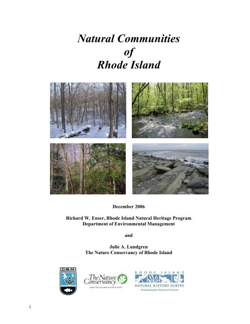
Natural Communities of Rhode Island - University of Rhode Island
Natural Communities of Rhode Island - University of Rhode Island
Natural Communities of Rhode Island - University of Rhode Island

Create successful ePaper yourself
Turn your PDF publications into a flip-book with our unique Google optimized e-Paper software.
i<br />
<strong>Natural</strong> <strong>Communities</strong><br />
<strong>of</strong><br />
<strong>Rhode</strong> <strong>Island</strong><br />
December 2006<br />
Richard W. Enser, <strong>Rhode</strong> <strong>Island</strong> <strong>Natural</strong> Heritage Program<br />
Department <strong>of</strong> Environmental Management<br />
and<br />
Julie A. Lundgren<br />
The Nature Conservancy <strong>of</strong> <strong>Rhode</strong> <strong>Island</strong>
Citation: Enser, R. W. and J. A. Lundgren. 2006. <strong>Natural</strong> <strong>Communities</strong> <strong>of</strong> <strong>Rhode</strong> <strong>Island</strong>. A joint<br />
project <strong>of</strong> the <strong>Rhode</strong> <strong>Island</strong> Dept. <strong>of</strong> Environmental Management <strong>Natural</strong> Heritage Program and The<br />
Nature Conservancy <strong>of</strong> <strong>Rhode</strong> <strong>Island</strong>. Web published by R.I. <strong>Natural</strong> History Survey, Kingston, RI.<br />
www.rinhs.org.<br />
Cover Photos © The Nature Conservancy: Oak – Hickory Forest (top right) & Oak – Holly Forest<br />
(lower right) by Julie Lundgren, TNC and Marine Intertidal Rocky Shore (lower left) & Upper<br />
Perennial Stream/River (upper left) by John Berg, TNC.<br />
Current contact information for authors:<br />
Julie Lundgren, P.O. Box 2077, South Burlington VT 05407 ecojal18@yahoo.com<br />
Rick Enser, rickenser@yahoo.com<br />
ii
Acknowledgements<br />
Rick Enser, coordinator <strong>of</strong> the RI <strong>Natural</strong> Heritage Program under RI DEM, authored the first<br />
edition <strong>of</strong> the <strong>Natural</strong> <strong>Communities</strong> <strong>of</strong> <strong>Rhode</strong> <strong>Island</strong> (Enser 2000) which is the platform for this<br />
revision. Thanks to many ecologists in the northeast network <strong>of</strong> state natural heritage programs, The<br />
Nature Conservancy, and NatureServe for their work on regional and state classifications which<br />
greatly informed the RI work.<br />
Among the first state-specific community classifications to be published and widely used in the<br />
northeast was Carol Reschke’s first edition <strong>of</strong> Ecological <strong>Communities</strong> <strong>of</strong> New York State (Reschke<br />
1990). This provided inspiration to all the northeastern <strong>Natural</strong> Heritage programs to create, expand<br />
and revise similar documents. Lesley Sneddon, Mark Anderson, Ken Metzler and Tom Rawinski<br />
contributed significantly to the development <strong>of</strong> regional and state classifications with the<br />
collaboration <strong>of</strong> state ecologists across the northeast. Frank Golet and the work <strong>of</strong> his many students<br />
added substantially to our understanding <strong>of</strong> wetlands in <strong>Rhode</strong> <strong>Island</strong> and the region.<br />
Thanks to reviewers and those who provided additional guidance for this revision: Peter August,<br />
Nels Barrett, Peter Burn, Gregg Cassidy, Helen Cottrell, Alex Frost, Frank Golet, Lisa Gould, Tom<br />
Kutcher, Hope Leeson, Joanne Michaud, Carol Murphy, Garry Plunkett, Chris Powell, Chris<br />
Raithel, Scott Ruhren and Pat Swain. We regret any omissions and acknowledge that earlier<br />
editions benefited from the insight and data from others not recognized here. In addition, the R.I.<br />
<strong>Natural</strong> History Survey (RINHS) has been instrumental in taking on the management <strong>of</strong> the R.I.<br />
<strong>Natural</strong> Heritage database and we thank Erik Endrulat for his skilled work in maintaining and<br />
expanding the natural community component <strong>of</strong> that database including integration <strong>of</strong> this<br />
classification.<br />
J. Lundgren 2006<br />
iii
This page blank for double sided printing.<br />
iv
Introduction to the <strong>Natural</strong> Community Classification <strong>of</strong> <strong>Rhode</strong> <strong>Island</strong><br />
A natural community is an assemblage <strong>of</strong> organisms, their physical environment, the interactions<br />
among them, and the natural processes that affect them. <strong>Communities</strong> can be defined based<br />
primarily on plant species, geologic characteristics, animal assemblages, or other factors. This<br />
document defines natural communities primarily by dominant or characteristic plant species as they<br />
occur in assemblages repeated on the landscape. These are <strong>of</strong>ten tied to specific physical settings.<br />
This document provides a consistent language for describing and naming the natural communities <strong>of</strong><br />
<strong>Rhode</strong> <strong>Island</strong> in an easily accessible format that is useful to a variety <strong>of</strong> users: land trusts, land use<br />
planners, biologists, hikers, land owners, consultants and others. The classification is organized by<br />
Systems, which refer to complexes <strong>of</strong> natural communities that share the influence <strong>of</strong> similar<br />
hydrologic, geomorphologic, chemical, and biological factors. There are six systems in <strong>Rhode</strong><br />
<strong>Island</strong>: Marine, Estuarine, Riverine, Lacustrine, Palustrine, and Upland. Systems are divided<br />
into Subsystems (e.g., Open vs. Forested) that aid in the identification or categorization <strong>of</strong> a<br />
particular community type.<br />
The community types identified in each system and subsystem are distinguished by physiognomy<br />
(primary growth form <strong>of</strong> the vegetation), species composition, and ecological processes. The names<br />
assigned to each community type are descriptive labels and are not intended to describe all <strong>of</strong> the<br />
dominant species or the significant features. <strong>Communities</strong> may be named for a physiographic<br />
location (Maritime Beach Strand); the physiognomy <strong>of</strong> the vegetation (Dwarf Shrub Fen / Bog); or<br />
dominant species (Oak / Heath Forest). A diagnostic key is available to accompany the<br />
classification that will assist in identifying communities in the field.<br />
The descriptions <strong>of</strong> each community type include dominant species (most abundant or greatest<br />
percent cover) and characteristic species (commonly found in community occurrences, although<br />
not necessarily abundant). An individual community example or occurrence (i.e., site) may not<br />
contain all <strong>of</strong> the species listed in the description. Moreover, the description includes only a very<br />
small portion <strong>of</strong> the total number <strong>of</strong> species present in that community type. <strong>Natural</strong> communities<br />
are inherently variable and it takes experience in the field to become familiar with the range <strong>of</strong><br />
variability within types. In addition, natural communities are dynamic; changing in age, structure<br />
and composition over time and in response to natural disturbances such as flooding, wind storms,<br />
wildfire, disease outbreaks, etc.<br />
The prevalence <strong>of</strong> non-native species in some locations can also add to the confusion in identifying<br />
a natural community occurrence. In general, one should rely on the physiognomy (structure) and<br />
native species composition to select the closest match. Sites dominated by non-native species are<br />
generally not included in this document (with a few exceptions such as Phragmites marsh) and the<br />
percentage <strong>of</strong> native versus non-native species is an important factor in identifying the best examples<br />
<strong>of</strong> a particular type. Sites with a higher percentage <strong>of</strong> non-native species are essentially poorer<br />
quality examples <strong>of</strong> a given community than sites strongly dominated by native species.<br />
1
Descriptions may include information on important environmental characteristics (hydrology,<br />
substrate, topography, etc.) and disturbance patterns (e.g., periodic flooding, fire). In addition, for<br />
each community type a generalized distribution within <strong>Rhode</strong> <strong>Island</strong>, and a few examples <strong>of</strong> places<br />
to view them is included. Organizations such as the <strong>Rhode</strong> <strong>Island</strong> <strong>Natural</strong> History Survey (RINHS),<br />
Audubon Society <strong>of</strong> <strong>Rhode</strong> <strong>Island</strong> (ASRI), The Nature Conservancy (TNC), <strong>Rhode</strong> <strong>Island</strong> Wild<br />
Plant Society (RIWPS) and others can provide opportunities to see and learn about the state’s natural<br />
communities. Contact information for these groups is included below.<br />
<strong>Natural</strong> community classifications may follow different structures and formats, with advantages and<br />
disadvantages to each. The full hierarchy is not outlined in this document and this classification is<br />
not intended as a hierarchiacal and numerical mapping tool; however, this classification can be<br />
adopted or cross-referenced to other schemes. For example, it can be linked to other systems such as<br />
the U. S. Fish and Wildlife Service wetland classification (Cowardin, et al., 1979), or to regional and<br />
national classifications developed cooperatively by The Nature Conservancy, NatureServe and state<br />
<strong>Natural</strong> Heritage Programs (e.g., Anderson, et al., 1998). A cross-walk to the RI <strong>Natural</strong> Heritage<br />
mapping names is included in this document.<br />
Plant taxonomy and nomenclature generally follows Gould et al. (1998), which is based on Gleason<br />
and Cronquist (1991), but some recent nomenclatural changes have also been adopted. Vertebrate<br />
animal taxonomy and names follow August et al. (2001).<br />
References Cited:<br />
Anderson M., P. Bourgeron, M. T. Breyer, R. Crawford, L. Engelking, D. Faber-Langendoen, M.<br />
Gallyoun, K. Gooden, D.H. Grossman, S. Landaal, K. Metzler, K.D. Patterson, M. Pyne, M. Reid,<br />
L.Sneddon,, and A.S. Weakley. 1998. International Classification <strong>of</strong> Ecological <strong>Communities</strong>:<br />
Terrestrial Vegetation <strong>of</strong> the United States.Volume II. The National Vegetation Classification<br />
System: List <strong>of</strong> types. The Nature Conservancy, Arlington, Virginia. 502 pp.<br />
(www.natureserve.org)<br />
August, P.V., R.W. Enser, and L.L. Gould (editors). 2001. The vertebrates <strong>of</strong> <strong>Rhode</strong> <strong>Island</strong>. Vol. 2<br />
<strong>of</strong> the biota <strong>of</strong> <strong>Rhode</strong> <strong>Island</strong>. RI <strong>Natural</strong> History Survey, Kingston, RI. 84pp.<br />
Cowardin, L.M., V. Carter, F.C. Golet, and E.T. LaRoe. 1979. Classification <strong>of</strong> wetlands and<br />
deepwater habitats <strong>of</strong> the United States. Office <strong>of</strong> Biological Sciences, U.S. Fish and Wildlife<br />
Service, U.S. Department <strong>of</strong> the Interior, Washington, D.C. 131 pp.<br />
Enser, R.W. 2000. <strong>Natural</strong> communities <strong>of</strong> <strong>Rhode</strong> <strong>Island</strong>. Unpubl. report <strong>of</strong> the <strong>Rhode</strong> <strong>Island</strong><br />
<strong>Natural</strong> Heritage Program, RI Dept <strong>of</strong> Environmental Management, Providence RI.<br />
Gleason, H.A. and A. Cronquist. 1991. Manual <strong>of</strong> vascular plants <strong>of</strong> northeastern United States and<br />
adjacent Canada, second edition. The New York Botanical Garden, New York, NY. 910 pp.<br />
2
Gould, L.L., R.W. Enser, R.E. Champlin and I. H. Stuckey. 1998. Vascular flora <strong>of</strong> <strong>Rhode</strong> <strong>Island</strong>: a<br />
list <strong>of</strong> native and naturalized plants. Vol. 1 <strong>of</strong> the biota <strong>of</strong> <strong>Rhode</strong> <strong>Island</strong>. <strong>Rhode</strong> <strong>Island</strong> <strong>Natural</strong><br />
History Survey, Kingston RI.<br />
Reschke, C. 1990. Ecological <strong>Communities</strong> <strong>of</strong> New York State. New York <strong>Natural</strong> Heritage<br />
Program, NewYork State Depatment <strong>of</strong> Environmental Conservation. 96 pp.<br />
3
SOURCES OF INFORMATION ON PLACES TO VISIT, FIELD TRIPS, SPECIAL<br />
PROGRAMS & OTHER RESOURCES IN RHODE ISLAND:<br />
RI Department <strong>of</strong> Environmental Management<br />
235 Promenade Street<br />
Providence RI 02908<br />
401-222-6800 general info<br />
www.dem.ri.gov (see Planning and Development, Water Resources and <strong>Natural</strong> Resources Bureau)<br />
<strong>Rhode</strong> <strong>Island</strong> <strong>Natural</strong> History Survey<br />
Room 101, Coastal Institute in Kingston<br />
1 Greenhouse Rd<br />
<strong>University</strong> <strong>of</strong> <strong>Rhode</strong> <strong>Island</strong><br />
Kingston RI 02881<br />
401-874-5800<br />
www.rinhs.org<br />
The Nature Conservancy<br />
159 Waterman Street<br />
Providence RI 02906<br />
401-331-7110<br />
www.nature.org/rhodeisland<br />
Audubon Society <strong>of</strong> <strong>Rhode</strong> <strong>Island</strong> (Headquarters)<br />
12 Sanderson Road<br />
Smithfield RI 02917<br />
401-949-5454<br />
www.asri.com<br />
<strong>Rhode</strong> <strong>Island</strong> Wild Plant Society<br />
P.O. Box 2488<br />
Providence RI 02906<br />
401-453-3777<br />
www.riwps.org<br />
New England Wildflower Society<br />
180 Hemenway Road<br />
Framingham MA 01701<br />
508-877-7630<br />
www.newfs.org<br />
4
TABLE OF CONTENTS<br />
I. Marine System ................................................................................................................................. 9<br />
A. Marine Subtidal ...................................................................................................................................... 9<br />
1. Marine Open Water _______________________________________________________________ 9<br />
2. Marine Subtidal Aquatic Bed________________________________________________________ 9<br />
B. Marine Intertidal .................................................................................................................................... 9<br />
1. Marine Intertidal Mud Flat__________________________________________________________ 9<br />
2. Marine Intertidal Sand/Gravel Beach_________________________________________________ 10<br />
3. Marine Intertidal Rocky Shore______________________________________________________ 10<br />
II. Estuarine System.......................................................................................................................... 11<br />
A. Estuarine Subtidal ................................................................................................................................ 11<br />
1. Tidal River/Stream _______________________________________________________________ 11<br />
2. Tidal Creek_____________________________________________________________________ 11<br />
3. Brackish Subtidal Aquatic Bed _____________________________________________________ 11<br />
4. Coastal Salt Pond ________________________________________________________________ 12<br />
B. Estuarine Intertidal .............................................................................................................................. 12<br />
1. Brackish Intertidal Flat____________________________________________________________ 12<br />
2. Brackish Marsh _________________________________________________________________ 12<br />
3. Low Salt Marsh _________________________________________________________________ 13<br />
4. High Salt Marsh _________________________________________________________________ 13<br />
5. Salt Panne______________________________________________________________________ 13<br />
6. Salt Shrub______________________________________________________________________ 14<br />
III. Riverine System (freshwater)..................................................................................................... 15<br />
A. Non-tidal River...................................................................................................................................... 15<br />
1. Upper Perennial Stream/River ______________________________________________________ 15<br />
2. Lower Perennial Stream/River ______________________________________________________ 15<br />
3. Intermittent Stream_______________________________________________________________ 15<br />
4. Blackwater Creek ________________________________________________________________ 16<br />
B. Tidal River (freshwater reach; see Estuarine System for brackish reach)...................................... 16<br />
1. Fresh Subtidal Aquatic Bed ________________________________________________________ 16<br />
2. Freshwater Tidal Marsh ___________________________________________________________ 16<br />
IV. Lacustrine System....................................................................................................................... 17<br />
A. Mesotrophic Lake ................................................................................................................................. 17<br />
B. Mesotrophic Pond ................................................................................................................................. 17<br />
C. Coastal Plain Pond................................................................................................................................ 17<br />
D. Eutrophic Pond ..................................................................................................................................... 18<br />
5
V. Palustrine System ......................................................................................................................... 19<br />
(note: substrate is used as an organizing feature rather than a clear taxonomic division. When in<br />
doubt, refer to all the wetlands that match the physiognomy (open types/ A & B or forested types/<br />
C&D).<br />
A. Open Wetlands (non-forested) on Mineral Soil..................................................................................19<br />
1. Common Pond or Lake Shore (herbaceous community) __________________________________19<br />
2. Coastal Plain Pondshore ___________________________________________________________19<br />
a. Seasonally Flooded Coastal Plain Pondshore_________________________________________20<br />
b. Semi-permanently Flooded Coastal Plain Pondshore __________________________________20<br />
3. Interdunal Swale _________________________________________________________________20<br />
4. Semipermanently Flooded (Deep) Emergent Marsh _____________________________________20<br />
a. Cattail Marsh _________________________________________________________________21<br />
b. Pickerelweed – Mixed Forbs Marsh________________________________________________21<br />
c. Phragmites Marsh (non-native) ___________________________________________________21<br />
5. Seasonally Flooded (Shallow) Emergent Marsh_________________________________________21<br />
6. Wet Meadow____________________________________________________________________21<br />
7. Shrub Swamp ___________________________________________________________________22<br />
B. Open Peatlands ......................................................................................................................................22<br />
1. Acidic Graminoid Fen ____________________________________________________________22<br />
2. Coastal Plain Quagmire ___________________________________________________________23<br />
3. Sea Level Fen ___________________________________________________________________23<br />
4. Dwarf Shrub Fen/ Bog ____________________________________________________________23<br />
5. Dwarf Tree Bog _________________________________________________________________24<br />
a. Black Spruce Shrub Bog_________________________________________________________24<br />
b. Atlantic White Cedar Shrub Bog __________________________________________________24<br />
C. Forested Mineral Soil Wetlands..........................................................................................................24<br />
1. Floodplain Forest ________________________________________________________________24<br />
a. Silver Maple - Sycamore Floodplain Forest__________________________________________25<br />
b. Red Maple - Pin Oak Floodplain Forest_____________________________________________25<br />
c. Red Maple –Ash Swamp (see below)_______________________________________________25<br />
2. Red Maple Swamp _______________________________________________________________25<br />
a. Red Maple - Deciduous Shrub Swamp______________________________________________25<br />
a1. Red Maple – Ash Swamp_____________________________________________________________ 26<br />
a2. Red Maple – Black Gum Swamp_______________________________________________________ 26<br />
a3. Rich Red Maple – Ash Swamp ________________________________________________________ 26<br />
b. Red Maple – Rhododendron Swamp _______________________________________________27<br />
3. Swamp White Oak Swamp _________________________________________________________27<br />
4. Hemlock – Hardwood Swamp ______________________________________________________27<br />
5. Vernal Pool ____________________________________________________________________27<br />
6. Forested Seep___________________________________________________________________28<br />
a. Headwater Seep _______________________________________________________________28<br />
b. Hillside Seep__________________________________________________________________28<br />
7. Spring_________________________________________________________________________28<br />
D. Forested Peatlands ................................................................................................................................28<br />
1. Atlantic White Cedar Swamp _______________________________________________________28<br />
a. Atlantic White Cedar / Rhododendron Swamp _______________________________________29<br />
6
. Atlantic White Cedar – Hardwood Swamp __________________________________________ 29<br />
b1. Atlantic white cedar – swamp azalea type ________________________________________________29<br />
b2. Atlantic white cedar - hemlock - yellow birch type _________________________________________30<br />
2. Black Spruce Bog________________________________________________________________ 30<br />
VI. Upland System. ........................................................................................................................... 31<br />
A. Open Uplands (non-forested)............................................................................................................... 31<br />
1. Inland Sand Barren_______________________________________________________________ 31<br />
2. Maritime Beach Strand____________________________________________________________ 31<br />
3. Maritime Dune __________________________________________________________________ 31<br />
a. Beach Grass Dune Association ___________________________________________________ 32<br />
b. Beach Heather Dune Association _________________________________________________ 32<br />
c. Dune Shrub Association_________________________________________________________ 32<br />
4. Maritime Grassland ______________________________________________________________ 32<br />
5. Maritime Rocky Cliff_____________________________________________________________ 33<br />
6. Maritime Bluff __________________________________________________________________ 33<br />
7. Maritime Shrubland (also commonly known as “Coastal Shrubland”________________________ 33<br />
B. Woodlands ............................................................................................................................................. 33<br />
1. Maritime Woodland/ Forest _______________________________________________________ 34<br />
2. Pitch Pine / Scrub Oak Barrens _____________________________________________________ 34<br />
3. Red Cedar Rocky Summit _________________________________________________________ 34<br />
C. Forested Uplands .................................................................................................................................. 35<br />
1. Oak / Heath Forest _______________________________________________________________ 35<br />
a. Black Oak - Scarlet Oak / Heath Forest _____________________________________________ 35<br />
b. Chestnut Oak Forest____________________________________________________________ 35<br />
c. White Oak / Mountain Laurel Forest _______________________________________________ 35<br />
2. Oak – Hickory Forest _____________________________________________________________ 36<br />
3. Oak – Holly Forest _______________________________________________________________ 36<br />
4. Mesic Beech – Maple – Red Oak Forest ______________________________________________ 37<br />
5. High Terrace Riverside Forest ______________________________________________________ 37<br />
6. Pitch Pine - Oak Forest____________________________________________________________ 37<br />
7. White Pine – Oak Forest __________________________________________________________ 38<br />
8. Hemlock – Hardwood Forest _______________________________________________________ 38<br />
Note: The naming <strong>of</strong> community types follows a simplified version <strong>of</strong> the conventions adopted for<br />
the National Vegetation Classification (TNC and NatureServe): Title species are either dominant or<br />
simply characteristic <strong>of</strong> the community. Dashes and slashes between species names indicate similar<br />
or different physiognomic strata (tree, shrub or herb layer). For example Oak – Holly Forest<br />
indicates that these species are all in one strata compared to Oak / Heath Forest which is comprised<br />
<strong>of</strong> oaks in the tree layer and heath species in a lower strata (in this case shrub layer).<br />
7
This page blank for double sided printing.<br />
8
I. Marine System<br />
This system consists <strong>of</strong> open ocean, shallow saline coastal bays lacking significant freshwater<br />
inflow, and associated high-energy coasts. The limits extend from mean high water seaward,<br />
beyond the limits <strong>of</strong> rooted vascular vegetation. Salinity is greater than 18.0 parts per thousand (ppt)<br />
ocean-derived salts.<br />
A. Marine Subtidal. This subsystem includes the area below the lowest tide that is permanently<br />
underwater. Salinity levels are fairly constant within a range <strong>of</strong> 25.0 to 32.0 ppt.<br />
1. Marine Open Water. A broadly defined community describing life in the open ocean from<br />
the lowest tide level along the shore to the seaward limits <strong>of</strong> rooted vascular vegetation, or<br />
photic zone and adjacent deeper waters. This community includes all substrate types<br />
(ranging from rock bottom to unconsolidated bottom) and has sparse to no rooted vegetation<br />
or macroalgae. Associated fauna includes a large number <strong>of</strong> fish species and mollusks such<br />
as surf clam (Spisula solidissima) in near-shore waters and ocean quahog (Artica islandica)<br />
in deeper waters.<br />
Dist: Open ocean along southern coast, around Block <strong>Island</strong>, extending into<br />
Narragansett Bay.<br />
2. Marine Subtidal Aquatic Bed. Community <strong>of</strong> macroalgae and rooted vegetation occurring<br />
in quiet waters below the lowest tide level where fluctuations in salinity are minor. Includes<br />
“Eelgrass Beds” and macroalgae beds. Characteristic species include eelgrass (Zostera<br />
marina), sea lettuce (Ulva lactuca), kelp (Laminaria spp.), Irish moss (Chondrus crispus),<br />
and other macroalgae including other Ulva spp. (formerly Enteromorpha) and Cladophora.<br />
Many other algae species may be present. Green fleece (Codium fragile), a non-native algae,<br />
frequently invades this community. Characteristic fauna include bay scallops (Aequipecten<br />
irradians), northern quahog (Mercenaria mercenaria), Atlantic slippershell (Crepidula<br />
fornicata), and winter flounder (Pseudopleuronectes americanus). (See also, closely related<br />
Brackish Subtidal Aquatic Bed under Estuarine System).<br />
Dist: In lower Narragansett Bay and Long <strong>Island</strong> Sound, fringing shore and islands.<br />
The Eelgrass Bed association is extremely limited due to losses from eelgrass wasting<br />
disease. Eelgrass restoration efforts are ongoing.<br />
B. Marine Intertidal. This subsystem includes the area between the highest and lowest tide levels.<br />
The substrate is periodically exposed and flooded by semidiurnal tides, and salinity levels can<br />
fluctuate widely.<br />
1. Marine Intertidal Mud Flat. Quiet water community with a substrate composed <strong>of</strong> silt or<br />
sand rich in organic matter and poorly drained at low tide. Microalgae, including diatoms,<br />
are a key component <strong>of</strong> this community and the mud surface is <strong>of</strong>ten coated with a thin mat<br />
<strong>of</strong> algae. Characteristic organisms include sand worms (polychaetes), mudsnail (Ilyanassa<br />
obsoleta), s<strong>of</strong>tshell clam (Mya arenaria), and blue mussel (Mytilus edulis). This community<br />
is an important feeding area for shorebirds and some areas may be critical as migratory bird<br />
9
concentration areas.<br />
Dist: In salt ponds and coves along the seacoast and in Narragansett Bay.<br />
Examples: Quonochontaug Pond, Charlestown; Galilee Salt Marsh, Narragansett.<br />
2. Marine Intertidal Sand/Gravel Beach. Community washed by high-energy waves, with<br />
sand and gravel substrates that are well-drained at low tide and subject to high fluctuations in<br />
salinity and moisture. It occurs between the low and high tide lines, and the upper edge is<br />
<strong>of</strong>ten marked by a wrack line <strong>of</strong> plant debris washed up by the tide. This community is<br />
characterized by benthic invertebrate fauna including mole crabs (Emeritia talpoida), sand<br />
worms (polychaetes), and amphipods, and is an important feeding area for migratory<br />
shorebirds, a characteristic species being the sanderling (Calidris alba). The Marine<br />
Intertidal Sand/Gravel Beach lacks the vascular plants <strong>of</strong> the Maritime Beach Strand<br />
community which occurs above the intertidal zone (see Uplands section).<br />
Dist: Along the seacoast and lower Narragansett Bay.<br />
Examples: Moonstone Beach, South Kingstown; Goosewing Beach, Little Compton.<br />
3. Marine Intertidal Rocky Shore. Community <strong>of</strong> rocky shores exposed to high-energy waves<br />
and alternately exposed and inundated by the tides. Occurs below the high tide line and<br />
above the limit <strong>of</strong> the lowest tide. Organisms include those capable <strong>of</strong> withstanding wave<br />
impact and periodic desiccation, including attached algae, sea mussel (Mytilus edulis), sea<br />
star (Asterias spp.), sea urchin (Arbacia punctulata), and rock barnacle (Balanus<br />
balanoides). The community is typically species rich with over 60% <strong>of</strong> the substrate covered<br />
with attached organisms. Characteristic algae are rockweeds (Ascophyllum nodosum, Fucus<br />
spp.), Irish moss (Chondrus crispus), kelp (Laminaria spp.), and others (Ulva/ Enteromorpha<br />
spp., Rhizoclonium spp.). Used as winter foraging habitat for purple sandpiper (Calidris<br />
maritima), harlequin ducks (Histrionicus histrionicus) and eider ducks (Somateria<br />
mollissima).<br />
Dist: <strong>Island</strong>s and shore <strong>of</strong> lower Narragansett Bay.<br />
Examples: Sachuest Point National Wildlife Refuge, Middletown; Beavertail Point,<br />
Jamestown; Colt State Park, Bristol.<br />
10
II. Estuarine System<br />
This system consists <strong>of</strong> deepwater tidal habitats and adjacent tidal wetlands that are semi-enclosed<br />
by land but have open, partly obstructed, or ephemeral access to the open ocean, and in which ocean<br />
water is partially diluted by freshwater influx. This system extends from the upstream limit <strong>of</strong> tidal<br />
influence seaward to an imaginary line closing the mouth <strong>of</strong> a bay or river. Salinity is >0.5 parts per<br />
thousand (ppt).<br />
A. Estuarine Subtidal. This subsystem includes the area below the lowest tide where the substrate is<br />
permanently flooded and continuously submerged.<br />
1. Tidal River/Stream. The aquatic community <strong>of</strong> continuously flooded substrates that<br />
supports no emergent vegetation. A vertical salinity gradient is maintained in which the<br />
surface layer <strong>of</strong> fresh water (0.5 ppt) floats over a deeper brackish layer (0.5 to18.0 ppt).<br />
Characteristic fish are anadromous species including alewife (Alosa pseudoharengus),<br />
blueback herring (Alosa aestivalis), and shad (Alosa sapidissima).<br />
Dist: Rivers within Narragansett Bay region.<br />
Examples: Pawcatuck River, Narrow River<br />
2. Tidal Creek. Aquatic community <strong>of</strong> a continuously flooded creek that drains the tidal<br />
waters <strong>of</strong> a coastal salt marsh. Water is brackish to saline (0.5 to 30.0 ppt). Water levels<br />
fluctuate with the tides; the creek bottom is permanently flooded, but the banks are exposed<br />
at low tide. Characteristic plants include widgeon grass (Ruppia maritima) and several<br />
cyanophyta. Fiddler crabs (Uca spp.) are common burrowers in the banks. Typical fish<br />
include mummichog (Fundulus heteroclitus), striped killifish (Fundulus majalis), and<br />
threespine stickleback (Gasterosteus aculeatus).<br />
Dist: Tidal marshes along the seacoast and Narragansett Bay.<br />
Example: Galilee Salt Marsh, Narragansett; Seapowet Marsh, Tiverton<br />
3. Brackish Subtidal Aquatic Bed. An estuarine community <strong>of</strong> continuously flooded<br />
substrates supporting rooted aquatic vegetation and associated macroalgae. Water is<br />
generally less than 6.6 ft (2 m) deep at low tide, and salinity ranges between 0.5 to 18.0 ppt.<br />
The characteristic plant <strong>of</strong> higher salinity beds is eelgrass (Zostera marina) with associated<br />
macroalgae including the genera Ulva (Enteromorpha), Chaetomorpha, Gracilaria,<br />
Agardhiella, Ectocarpus, and Pilayella. Lower salinity beds are characterized by widgeon<br />
grass (Ruppia maritima), wild celery (Vallisneria americana), horned pondweed<br />
(Zannichellia palustris), sago pondweed (Potamogeton pectinatus), clasping-leaved<br />
pondweed (Potamogeton perfoliatus), and naiads (Najas spp.), along with algal forms Ulva<br />
(Enteromorpha), Cladopora, and Chara. Aquatic beds serve as feeding grounds for<br />
American black duck (Anas rubripes) and brant (Branta bernicla), and nursery grounds for a<br />
wide diversity <strong>of</strong> fish and shellfish. Often adjacent to Brackish Intertidal Flat and/or Brackish<br />
Marsh.<br />
Dist: Brackish areas <strong>of</strong> Narragansett Bay and the permanently flooded portion <strong>of</strong><br />
coastal salt ponds in Washington and Newport counties.<br />
11
Examples: Ninigret Pond & Trustom Pond in Charlestown.<br />
4. Coastal Salt Pond. This is a coarsely defined type that includes Intertidal and Subtidal<br />
habitats. These brackish ponds occur along the coastal edge, partially closed <strong>of</strong>f from the sea<br />
by barrier beaches. Salinity may vary from nearly fresh to nearly saline depending on<br />
duration and extent <strong>of</strong> connection to the sea. Ocean waters enter the pond during storm<br />
events or when increased freshwater input on the landward side creates a breach to the ocean<br />
that may remain open for short or prolonged periods resulting in wide variations in salinity.<br />
Many ponds have been altered on the <strong>Rhode</strong> <strong>Island</strong> shore by the construction <strong>of</strong> permanent<br />
breachways. Two types <strong>of</strong> ponds are recognized: those with significant freshwater input<br />
from streams (restricted to eastern R.I.) and those with diffuse freshwater input and little or<br />
no stream connection (e.g., Washington County and Block <strong>Island</strong>). The vegetation is<br />
comprised <strong>of</strong> finer scale communities (which see) nested within this type, including Brackish<br />
Marsh, Subtidal Aquatic Bed, and/or Brackish Intertidal Flat. These ponds are also critical<br />
nurseries and havens for shellfish and finfish.<br />
Dist: South shore <strong>of</strong> state and on Block <strong>Island</strong>.<br />
Examples: Sachem Pond, Block <strong>Island</strong>; Ninigret and Trustom Ponds, Charlestown;<br />
Quicksand Pond, Little Compton.<br />
B. Estuarine Intertidal. This subsystem includes areas between the highest and lowest tide levels<br />
where the substrate is regularly exposed and flooded by semi-diurnal tides. Some areas are only<br />
irregularly exposed at low tide; other areas are only irregularly flooded at high tide.<br />
1. Brackish Intertidal Flat. A sparsely vegetated community characterized by low-growing,<br />
rosette-forming aquatic plants. This community occurs on exposed intertidal mud or sandy<br />
flats where vegetation is usually submerged only during highest tides. Water is brackish (0.5<br />
to 16.0 ppt). Flats subject to daily flooding and higher salinity levels may be devoid <strong>of</strong><br />
macrophytes; characteristic plants <strong>of</strong> less frequently flooded and more brackish flats include<br />
mudwort (Limosella australis), horned pondweed (Zannichellia palustris), and spike rush<br />
(Eleocharis parvula), and microalgae. Two plant species typical <strong>of</strong> this community in<br />
Connecticut and Massachusetts but extirpated from <strong>Rhode</strong> <strong>Island</strong> are River-arrowhead<br />
(Sagittaria subulata), and Pygmy-weed (Crassula aquatica).<br />
Dist: Brackish ponds and edges <strong>of</strong> tidal marshes along the seacoast and Narragansett<br />
Bay.<br />
Examples: Narrow River, Narragansett; Hundred Acre Cove, Barrington.<br />
2. Brackish Marsh. A marsh community that occurs where water salinity ranges from 0.5 to<br />
18.0 ppt and water levels are 6 ft (2 m). This community consists <strong>of</strong> a combination <strong>of</strong> salt<br />
marsh and fresh marsh plants. Characteristic species include narrowleaf cattail (Typha<br />
angustifolia), freshwater cordgrass (Spartina pectinata), tall reed (Phragmites australis), salt<br />
marsh fleabane (Pluchea odorata), and rose mallow (Hibiscus moscheutos). The robust<br />
bulrush (Scirpus robustus), three-square bulrush (Spartina pungens), and spike rush<br />
(Eleocharis rostellata) may also be present. This community occurs in several<br />
environmental situations including the edges <strong>of</strong> tidal rivers, coastal ponds that maintain<br />
12
eachways to the ocean, and small barrier beach ponds that do not maintain permanent<br />
breachways, but exhibit higher salinity levels due to salt spray and occasional overwash.<br />
Additional study is needed to distinguish these types. This community provides nesting<br />
habitat for Virginia rail (Rallus limicola), sora (Porzana carolina), marsh wren (Cistothorus<br />
palustris), and other marsh birds.<br />
Dist: Coastal salt ponds and tidal rivers along the coast and Narragansett Bay.<br />
Examples: Trustom Pond, Charlestown; Narrow River, Narragansett; Lathrop<br />
Wildlife Refuge at Winnepaug Pond, Westerly; Providence River, Providence and<br />
East Providence; Tunipus Pond, Little Compton.<br />
3. Low Salt Marsh. A coastal marsh community in sheltered areas in a zone extending from<br />
mean high tide down to sea level, or to about 6.6 ft (2 m) below mean high tide. This<br />
community is regularly flooded by semidiurnal tides and is usually limited to the edges <strong>of</strong><br />
tidal creeks and the borders <strong>of</strong> tidal flats. The vegetation is <strong>of</strong>ten a monotypic stand <strong>of</strong> salt<br />
marsh cordgrass (Spartina alterniflora) in combination with dense mats <strong>of</strong> marine algae such<br />
as sea lettuce (Ulva/Enteromorpha spp.), rockweeds (Fucus spp. and Ascophyllum nodosus)<br />
and blue green algae. Characteristic animals include fiddler crabs (Uca spp.), salt marsh<br />
snails (Littorina spp.), ribbed mussel (Geukensia demmisa), and seaside sparrow<br />
(Ammodramus maritimus).<br />
Dist: Tidal marshes along the seacoast and Narragansett Bay.<br />
Examples: Galilee Salt Marsh, Narragansett; Touisset Marsh Wildlife Refuge,<br />
Warren; Seapowet Marsh, Tiverton; Providence River, Providence and East<br />
Providence.<br />
4. High Salt Marsh. A coastal marsh community in sheltered areas in a zone extending from<br />
mean high tide up to the limit <strong>of</strong> spring tidal flooding. This community is irregularly flooded<br />
by spring and flood tides. High salt marsh vegetation typically consists <strong>of</strong> a mosaic <strong>of</strong><br />
patches, each dominated by a single graminoid species, including salt-meadow cordgrass<br />
(Spartina patens), spike grass (Distichlis spicata), and black grass (Juncus gerardii). Other<br />
characteristic plants include sea-lavender (Limonium carolinianum), salt marsh aster<br />
(Symphyothrichum tenuifolim; formerly Aster tenuifolius), seaside gerardia (Agalinis<br />
maritima) and spearscale (Atriplex patula). The salt marsh snail (Melampus bidentatus) is a<br />
common animal <strong>of</strong> this community, and nesting birds include clapper rail (Rallus<br />
longirostris) and sharp-tailed sparrow (Ammodramus caudacutus).<br />
Dist: Tidal marshes along the seacoast and Narragansett Bay.<br />
Examples: Galilee Salt Marsh and Narrow River, Narragansett; Hundred Acre Cove,<br />
Barrington; Touisset Marsh, Warren; Emilie Ruecker Wildlife Refuge, Tiverton;<br />
Fogland Marsh Preserve, Tiverton<br />
5. Salt Panne. A poorly drained shallow depression within high or low salt marsh<br />
communities. Pannes in low marshes have substrates <strong>of</strong> s<strong>of</strong>t, silty mud, drain irregularly and<br />
are usually unvegetated. High marsh pannes are occasionally flooded, the ponded water<br />
evaporating and raising salinity to extreme levels. Characteristic plants include dwarf salt<br />
marsh cordgrass (Spartina alterniflora), glassworts (Salicornia spp.), salt marsh plantain<br />
13
(Plantago maritima var. juncoides), and sea blites (Suaeda spp.). Typically, the surface is<br />
covered with a thin, dense algal mat comprised <strong>of</strong> cyanobacteria and chlorophyta that<br />
contributes significantly to biomass production in this community. Within pannes, small<br />
ponds may form that are permanently inhabited by fish including mummichog (Fundulus<br />
heteroclitus) and sheepshead minnow (Cyprinodon variegatus).<br />
Dist: Tidal marshes along the seacoast and Narragansett Bay<br />
Examples: Galilee Salt Marsh, Narragansett; Emilie Ruecker Wildlife Refuge,<br />
Tiverton.<br />
6. Salt Shrub. A shrubland community that develops at the ecotone <strong>of</strong> salt marsh and upland<br />
where the elevation is somewhat higher than the adjacent salt marsh community and salinity<br />
levels are lower. Characteristic shrubs are salt marsh elder (Iva frutescens), groundsel-tree<br />
(Baccharis halimifolia), and pasture rose (Rosa carolina), with salt meadow cordgrass<br />
(Spartina patens) and switchgrass (Panicum virgatum) in the herbaceous understory. This<br />
community usually occurs as a linear feature along the upper edge <strong>of</strong> salt marshes, or as<br />
shrub islands on higher elevations within large marshes.<br />
Dist: Tidal marshes along the seacoast and Narragansett Bay.<br />
Examples: Galilee Salt Marsh, Narragansett; Fogland Marsh, Tiverton.<br />
14
III. Riverine System<br />
The riverine system consists <strong>of</strong> the aquatic communities <strong>of</strong> flowing waters where salinity is < 0.05<br />
ppt. This system is composed <strong>of</strong> deepwater habitats (> 6.6 ft) where persistent emergent vegetation<br />
is generally lacking, and shallow habitats where submerged or floating-leaved aquatic plants can<br />
occur. The Riverine communities are generally restricted to bottoms and aquatic beds in river<br />
channels, but may include vegetated shallow water communities along stream margins.<br />
A. Non-tidal River<br />
1. Upper Perennial Stream/River. Upper perennial streams have relatively steep gradients<br />
with well-defined riffles and pools. Water flow is constant, fast, and turbulent, and the<br />
normal water temperature is cold. Streambeds are narrow, shallow, and there is little<br />
floodplain development. Bottom substrates are composed <strong>of</strong> bedrock, boulder, stone, cobble,<br />
and occasional patches <strong>of</strong> sand. Characteristic fish include brook trout (Salvelinus<br />
fontinalis), longnose dace (Rhinichthys cataractae), blacknose dace (R. corporalis), and<br />
johnny darter (Etheostoma nigrum). Smaller streams may harbor amphibians including twolined<br />
salamander (Eurycea bislineata) and dusky salamander (Desmognathus fuscus).<br />
Mosses and periphytic algae are <strong>of</strong>ten present. Aquatic beds may occur locally with<br />
macrophytes such as waterweed (Elodea spp.), wild celery (Vallisneria americana), and<br />
pondweeds (Potamogeton spp.).<br />
Dist: Throughout <strong>Rhode</strong> <strong>Island</strong>.<br />
Examples: Queen, Upper Wood, Ponagansett, and Mossashuck Rivers.<br />
2. Lower Perennial Stream/River. Lower perennial streams have relatively low gradients and<br />
poorly defined pools and riffles. Water flow is constant but sluggish, and water temperature<br />
fluctuates widely. Streambeds are wide and there is usually a well-developed floodplain.<br />
Substrates are composed <strong>of</strong> finer sands and silts. Characteristic native fish include<br />
pumpkinseed (Lepomis gibbosus) and chain pickerel (Esox niger). Yellow perch (Perca<br />
flavescens) is a common introduced species. Aquatic beds may be well developed. Typical<br />
aquatic macrophytes include waterweed (Elodea canadensis), wild celery (Vallisneria<br />
americana), and linear-leaved pondweeds, such as sago pondweed (Potamogeton<br />
pectinatus).<br />
Dist: Larger streams/rivers in state, generally lacking in Bristol and Newport<br />
Counties, and Block <strong>Island</strong>.<br />
Examples: Pawcatuck River, Pawtuxet River, Blackstone River.<br />
3. Intermittent Stream. Channels <strong>of</strong> intermittent streams contain flowing water for only part<br />
<strong>of</strong> the year. When not actively flowing, water may be retained in isolated pools, or surface<br />
water may be absent. Faunal representatives include amphibians and invertebrates such as<br />
mayflies (Ephemeroptera), caddisflies (Tricoptera), stoneflies (Plecoptera), dragonflies<br />
(Odonata) and others that may inhabit the streambed only when water is flowing.<br />
Bryophytes such as Fontinalis spp. and Mnium spp. are characteristic. Intermittent streams<br />
are widely distributed throughout the <strong>Rhode</strong> <strong>Island</strong> landscape, but more inventories are<br />
15
needed to distinguish the plant and animal assemblages unique to this community. These<br />
reaches are <strong>of</strong>ten un-named and many are not shown on topographic maps or GIS stream<br />
coverages.<br />
Dist: Throughout <strong>Rhode</strong> <strong>Island</strong>.<br />
4. Blackwater Creek. Slow-moving stream through or originating in acidic shrub swamp<br />
and/or forested swamps, typically on the coastal plain. Waters are darkly stained with<br />
tannins from plant debris. Pondweeds (Potamogeton spp.) and waterweeds (Elodea spp.) are<br />
common. Characteristic <strong>of</strong> this community is the Blackwater bluet (Enallagma weewa), a<br />
damselfly that reaches its northern limit in <strong>Rhode</strong> <strong>Island</strong>. More inventories are needed to<br />
define this community in RI.<br />
Dist: Southern <strong>Rhode</strong> <strong>Island</strong>.<br />
Examples: Burlingame State Park, Charlestown.<br />
B. Tidal River (freshwater reach; see Estuarine System for brackish reach)<br />
1. Fresh Subtidal Aquatic Bed. The aquatic community <strong>of</strong> continuously flooded<br />
substrates supporting rooted aquatic vegetation. This community occurs in rivers and<br />
streams within the upper limits <strong>of</strong> tidal fluctuation where salinity is < 0.5 ppt. Characteristic<br />
plants are waterweed (Elodea spp.), along with wild celery (Vallisneria americana),<br />
pondweed (Potamogeton perfoliatus), and naiads (Najas spp.). Note that non-tidal<br />
freshwater aquatic beds are included in river and creek communities described above.<br />
Dist: Rare community type in <strong>Rhode</strong> <strong>Island</strong>.<br />
Examples: Lower reaches <strong>of</strong> Pawcatuck River.<br />
2. Freshwater Tidal Marsh. A marsh community occurring at the upper limits <strong>of</strong> tidal flow<br />
along streams and rivers. Salinity levels are < 0.5 ppt and water levels are < 6.6 ft (2 m).<br />
This community forms a transition between brackish marsh and nontidal fresh marsh and<br />
includes a combination <strong>of</strong> species typical <strong>of</strong> both, including narrow-leaved cattail (Typha<br />
angustifolia), bulrushes (Scirpus robustus, S. pungens, and S. validus), pickerelweed<br />
(Pontederia cordata), arrowweed (Sagittaria latifolia), spatterdock (Nuphar variegata),<br />
saltmarsh hemp (Amaranthus cannabinus) and water-parsnip (Sium suave). In addition,<br />
several indicator species are found exclusively in these restricted habitats, most notably wild<br />
rice (Zizania aquatica).<br />
Dist: Very rare community type in <strong>Rhode</strong> <strong>Island</strong>; historically on most major rivers in<br />
the state before construction <strong>of</strong> dams.<br />
Examples: Mill Creek, Warwick; Runnins River, East Providence.<br />
16
IV. Lacustrine System<br />
The lacustrine system consists <strong>of</strong> waters situated in topographic depressions or dammed river<br />
channels. Persistent emergent vegetation is lacking, but areas with submerged or floating-leaved<br />
aquatic plants may occur locally. The communities within this system – lakes and ponds – are<br />
distinguished by trophic state, annual cycles <strong>of</strong> thermal stratification, morphometry (size and shape),<br />
and water chemistry. Two subcategories <strong>of</strong> this system that are <strong>of</strong> particular conservation interest<br />
are ponds and lakes that support only native fish (i.e., not stocked with non-native species) and those<br />
that are naturally fishless.<br />
A. Mesotrophic Lake. The aquatic community <strong>of</strong> a relatively nutrient-poor lake. These lakes have<br />
two periods <strong>of</strong> mixing or turnover, spring and fall; they are thermally stratified in summer and<br />
winter.. Waters are moderately clear with medium transparency (Secchi disk depths <strong>of</strong> 2 to 4<br />
meters), and are moderately well-oxygenated. Lake sediments have low to moderate amounts <strong>of</strong><br />
organic matter. Characteristic native fishes include yellow perch (Perca flavescens), Eastern banded<br />
sunfish (Enneacanthus obesus), and pumpkinseed (Lepomis gibbosus). Introduced fish species<br />
include smallmouth bass (Micropterus dolomieui) and bluegill (Lepomis macrochirus). Pondweeds<br />
(Potamogeton spp.) and bladderworts (Utricularia spp.) are the most common submerged<br />
macrophytes.<br />
Dist: Throughout <strong>Rhode</strong> <strong>Island</strong>.<br />
Example: Wallum Lake, Burrillville.<br />
B. Mesotrophic Pond. A clear, shallow, moderate to low nutrient pond. The substrate is usually<br />
sandy or rocky and the ponds are too shallow to become stratified in the summer. Aquatic<br />
vegetation is <strong>of</strong>ten sparse. Characteristic floating-leaved plants include water-shield (Brasenia<br />
shreberi) and water-lily (Nymphaea odorata), and submerged species include bladderworts<br />
(Utricularia spp.), pondweeds (Potamogeton spp.), and water milfoil (Myriophyllum spp.). In<br />
shallower waters, rosette-leaved aquatics may occur including pipewort (Eriocaulon aquaticum) and<br />
water lobelia (Lobelia dortmanna). Fish populations are either warm-water or cold-water species,<br />
depending on summer temperatures. Those ponds without fish are particularly important breeding<br />
sites for some invertebrate and amphibian species. This type grades into and may be hard to<br />
distinguish from some examples <strong>of</strong> the Coastal Plain Pond community (see below) which is<br />
characterized by higher plant diversity and greatly fluctuating water levels.<br />
Dist: Throughout <strong>Rhode</strong> <strong>Island</strong>.<br />
Examples: Ashville and Blue Ponds, Hopkinton; Carr Pond, West Greenwich; freshwater<br />
ponds on Block <strong>Island</strong>.<br />
C. Coastal Plain Pond. The aquatic (permanently flooded) portion <strong>of</strong> shallow, clear, nutrient-poor<br />
ponds with seasonally fluctuating water levels. These are typically sandy- bottomed, occurring in<br />
glacial outwash or on the moraine and are best known for their unique pondshore flora (see Coastal<br />
Plain Pondshore community). Technically, some <strong>of</strong> the smaller or shallower coastal plain ponds fall<br />
strictly into the Palustrine System, but all are included here for ease <strong>of</strong> fuse <strong>of</strong> the classification. The<br />
pond community itself may be very similar to that <strong>of</strong> the Mesotrophic Pond above, but occurs in<br />
association with the Coastal Plain Pond Shore and/or Coastal Plain Quagmire <strong>Communities</strong> (which<br />
17
see). Odonates such as lateral bluet and pine barrens bluet (Enallagma laterale, E. recurvatum) are<br />
characteristic.<br />
Dist: Chiefly in Washington County.<br />
Example: Worden Pond, South Kingstown.<br />
D. Eutrophic Pond. The aquatic community <strong>of</strong> shallow, nutrient-rich ponds. These ponds are too<br />
shallow to become stratified in the summer. Water clarity is usually reduced due to accumulations<br />
<strong>of</strong> algae, and bottom substrates are usually mucky. Aquatic vegetation is abundant with<br />
characteristic submersed species including coontail (Ceratophyllum demersum), waterweed (Elodea<br />
canadensis), duckweed (Lemna spp.), and pondweeds (Potamogeton spp.). Fish populations are<br />
comprised <strong>of</strong> warm-water species. Note this type refers primarily to ponds with naturally high<br />
nutrient levels rather than culturally eutrophied waters.<br />
Dist: Throughout <strong>Rhode</strong> <strong>Island</strong>.<br />
18
V. Palustrine System<br />
The palustrine system includes all non-tidal perennial wetlands characterized by emergent<br />
vegetation, including wetlands permanently saturated by seepage, permanently flooded, and those<br />
seasonally or intermittently flooded (these may be seasonally dry). Vegetative cover is dominated<br />
by hydrophytes and the soil types are hydric. Wetland communities are generally distinguished by<br />
their plant composition, substrate, and hydrologic regime; however, the boundaries between<br />
wetlands are not <strong>of</strong>ten discrete and several types may occur together at the same site in a complex<br />
mosaic. [User note: substrate (mineral versus organic) is used here as a common organizing feature;<br />
but is not critical to identifying the correct community. If uncertain <strong>of</strong> the substrate type, browse<br />
through all <strong>of</strong> the options under the correct physiognomy (open or forested wetland) to find the best<br />
match.]<br />
Open (non-forested) - Trees absent or less than 50% cover or in rare cases, trees > 50% cover but<br />
shrub-like; less than 5 m (16 ft) tall.<br />
Forested - Dominated by > 50% canopy cover <strong>of</strong> woody vegetation, greater than 5 m (16 feet) in<br />
height. Vernal pools, forested seeps and springs are included here as these small communities<br />
generally occur within forested habitats.<br />
A. Open Wetlands (non-forested) on Mineral Soil. Trees absent or less than 50% cover (or in rare<br />
cases, tree species > 50% cover but shrub-like, less than 3m tall). Dominant vegetation is shrub<br />
and/or herbs. Substrates are on mineral soils (not peat or muck) or close to bedrock. Fluctuating or<br />
variable water levels allow seasonal aeration <strong>of</strong> the substrate and promote plant litter decomposition,<br />
minimizing peat accumulation.<br />
1. Common Pond or Lake Shore (herbaceous community). Sparsely to densely vegetated<br />
shoreline <strong>of</strong> ponds on sand to gravel soils with thin or no peat or muck accumulation. The<br />
common Pond or Lake Shore type captures the herbaceous shores <strong>of</strong> the majority <strong>of</strong> ponds in<br />
<strong>Rhode</strong> <strong>Island</strong>, and is characterized by a variety <strong>of</strong> sedges, annuals and perennials and is<br />
habitat for a number <strong>of</strong> odonates, aquatic invertebrates, amphibians and other species. The<br />
rarer subtype <strong>of</strong> Coastal Plain Pond Shore (below) is characterized by Atlantic coastal plain<br />
species or regional endemics and subject to the dramatic fluctuations in water level. Little<br />
attention has been paid to the common lake or pond shore community type and the ecological<br />
role; additional field data is needed to better describe this type.<br />
Dist: throughout <strong>Rhode</strong> <strong>Island</strong>.<br />
Examples: Beach Pond, Hopkinton; Watchaug Pond, Charlestown.<br />
2. Coastal Plain Pondshore. The gently sloping sandy/gravelly shores <strong>of</strong> ponds in morainal<br />
kettle holes, and depressions in glacial outwash plains within the coastal region.<br />
Representative floras include a high percentage <strong>of</strong> species typical <strong>of</strong> the Atlantic Coastal<br />
Plain; several odonates are also characteristic <strong>of</strong> this community such as New England Bluet<br />
and Pine Barrens Bluet (Enallagma laterale and E. recurvatum). Two variants are described<br />
19
that may co-occur at some Coastal Plain Ponds and in rare instances the seasonally flooded<br />
variant may occur as a wet meadow without a noticeable aquatic community.<br />
a. Seasonally Flooded Coastal Plain Pondshore. Vegetated shores <strong>of</strong> basin ponds that<br />
do not receive above ground inflow. Water levels fluctuate widely in response to<br />
water table change, and pond shores and bottoms may be exposed during the growing<br />
season. In such cases plants germinate from seeds banked in pond substrates<br />
producing vigorous populations that develop as concentric zones <strong>of</strong> vegetation, from<br />
shallow open water to upland shrub borders. More densely vegetated examples have<br />
the appearance <strong>of</strong> wet meadows. Characteristic plants include pipewort (Eriocaulon<br />
aquaticum), golden-pert (Gratiola aurea), umbrella-sedge (Cyperus dentatus),<br />
narrow-leaved goldenrod (Euthamia tenuifolia), mud-rush (Juncus pelocarpus), and<br />
Virginia meadow beauty (Rhexia virginica). Notable rare species include rose<br />
coreopsis (Coreopsis rosea), narrow-leaved arrowhead (Sagittaria teres), New<br />
England boneset (Eupatorium leucolepis var. novae-angliae), horned rush<br />
(Rhynchospora macrostachya), nutrush (Scleria reticularis), bald-rush (Rhychospora<br />
scirpoides), umbrella grass (Fuirena pumila), rattlebox (Crotalaria sagittalis) and<br />
tiny-flowered sedge (Hemicarpha micrantha).<br />
Dist: Southern <strong>Rhode</strong> <strong>Island</strong>.<br />
Examples: Matunuck Hills, S. Kingstown and other isolated examples; most<br />
on private lands accessible via guided walks with RIWPS or TNC.<br />
b. Semi-permanently Flooded Coastal Plain Pondshore. Vegetated shores <strong>of</strong> ponds<br />
that maintain relatively constant water levels from perennial stream inflow or<br />
recharge from bordering wetlands. Permanent emergent plant communities develop<br />
in the littoral zone in water depths <strong>of</strong> 0 to 3.3 ft (1 m). Characteristic plants include<br />
threesquare (Scirpus pungens), bayonnet rush (Juncus militaris), water lobelia<br />
(Lobelia dortmanna), pennywort (Hydrocotyle umbellata), yellow-eyed grass (Xyris<br />
difformis). Horsetail spike-rush (Eleocharis equisetoides) may be present. (See also<br />
related Coastal Plain Quagmire).<br />
Dist: Southern <strong>Rhode</strong> <strong>Island</strong>.<br />
Examples: Tucker Pond and Worden Pond, S. Kingstown.<br />
3. Interdunal Swale. Small wetlands that occur in low areas and blowouts within coastal sand<br />
dunes where the water table is at or near the surface. Soils are sand to peaty sand and water<br />
levels fluctuate seasonally and annually, corresponding to changes in groundwater levels.<br />
Vegetation ranges from sparse to dense, and from graminoid-dominated to low shrub mats.<br />
Characteristic species are rushes (Juncus canadensis, J. greenei), beakrush (Rhynchospora<br />
capitellata), yellow-eyed grass (Xyris torta), cranberry (Vaccinium macrocarpon), sweet gale<br />
(Myrica gale), and northern bayberry (Morella pensylvanica; formerly Myrica pensylanica).<br />
Dist: Rare community type along the south shore and Block <strong>Island</strong>.<br />
Example: Quonochontaug Beach, Charlestown.<br />
4. Semipermanently Flooded (Deep) Emergent Marsh. Marsh community on mineral soils<br />
20
with water depths ranging from 6 in. to 6.6 ft (15 cm to 2 m). Water levels may fluctuate<br />
seasonally but the substrate is rarely dry. May occur as fringe marshes along rivers, pond<br />
margins, or in basins. Characteristic vegetation is composed <strong>of</strong> emergent aquatics including<br />
cattails (Typha latifolia and T.angustifolia), bayonnet rush (Juncus militaris), s<strong>of</strong>tstem<br />
bulrush (Scirpus tabernaemontani), pickerelweed (Pontedaria cordata), arrow arum<br />
(Peltandra virginica), and burreed (Sparganium spp.). Floating-leaved plants include<br />
spatterdock (Nuphar variagata), water lily (Nymphaea odorata) and pondweeds<br />
(Potamogeton spp.). The non-native common reed (Phragmites australis) is a frequent<br />
invader <strong>of</strong> this community. Species composition <strong>of</strong> each community is highly variable<br />
depending on hydrologic regime, topographic position, and substrate. The Typha dominated<br />
“Cattail Marsh” is the most familiar form <strong>of</strong> this community. Red-winged blackbird<br />
(Agelaius phoenicus) and Virginia rail (Rallus limicola) are common residents along with<br />
several state-rare species including marsh wren (Cistothorus palustris) and pied-billed grebe<br />
(Podilymbus podiceps).<br />
Dist: Throughout <strong>Rhode</strong> <strong>Island</strong>.<br />
Examples: Simmons Mill Pond, Little Compton; Lonsdale Marsh/Valley Marsh<br />
Conservation Area, Lincoln.<br />
Several common types are based on the dominant species are:<br />
a. Cattail Marsh<br />
b. Pickerelweed – Mixed Forbs Marsh<br />
c. Phragmites Marsh (dominated by the non-native invasive variety; the native<br />
Phragmites is known only from small patches)<br />
5. Seasonally Flooded (Shallow) Emergent Marsh. Marsh community on mineral or muck<br />
soils that are permanently saturated and seasonally flooded. Water depths range from 6 in. to<br />
3.3 ft (15 cm to 1 m) during flood stages, but levels usually drop in mid to late summer<br />
exposing the substrate. Dominant plants include rice cutgrass (Leersia oryzoides), cattails<br />
(Typha spp.), s<strong>of</strong>t rush (Juncus effusus), Canada rush (Juncus canadensis), reed canary grass<br />
(Phalaris arundinacea), bluejoint (Calamagrostis canadensis), arrow arum (Peltandra<br />
cordata), manna grass (Glyceria canadensis), wool grass (Scirpus cyperinus), three-way<br />
sedge (Dulichium arundinaceum), tussock sedge (Carex stricta), and wild iris (Iris<br />
versicolor). Faunal associates include common yellowthroat (Dendroica petechia), redwinged<br />
blackbird (Agelaius phoenicus), marsh wren (Cistothorus palustris, state-rare), wood<br />
frog (Rana sylvatica), spring peeper (Pseudoacris crucifer), a wide diversity <strong>of</strong> odonates<br />
(dragonflies and damselflies), and other species.<br />
Dist: Throughout <strong>Rhode</strong> <strong>Island</strong>.<br />
Examples: Blackstone Valley Marshes, Cumberland and Lincoln.<br />
6. Wet Meadow. Graminoid and forb dominated meadows on soils that are seasonally<br />
saturated or flooded, but are drier and without standing water for most <strong>of</strong> the year. In a<br />
21
natural setting, the high water table prevents tree species from taking hold; however, wet<br />
meadows are <strong>of</strong>ten associated with agricultural settings, where woody species are kept at bay<br />
in part by grazing and/or mowing practices. Species composition is highly variable, but<br />
typically co-dominated by several species. Characteristic plants include Joe-pye-weed<br />
(Eupatorium spp.), wool-grass (Scirpus cyperinus), s<strong>of</strong>t rush (Juncus effusus), sensitive fern<br />
(Onoclea sensibilis), marsh fern (Thelypteris palustris), St. Johnswort (Hypericum spp.),<br />
sedge (Carex stipata), tussock sedge (Carex stricta), and bluejoint grass (Calamagrostis<br />
canadensis). Goldenrods (Solidago spp.) may be conspicuous in some meadows. Scattered<br />
shrubs may occur, but comprise less than 30% percent cover. Wet meadows are rich habitats<br />
for invertebrates, especially butterflies and other nectar feeders.<br />
Dist: Throughout the state.<br />
Examples: Pardon Gray Preserve, Tiverton; Sprague Hill Farm, Glocester.<br />
7. Shrub Swamp. Wetland communities dominated by shrubs 0.5 to 5 m tall that occur along<br />
the margin <strong>of</strong> a pond or river, isolated in a wet depression or valley, or as a transition<br />
community between a marsh and upland communities. The substrate is usually mineral soil<br />
or muck. This type is highly variable with the dominant shrub species dictated by local<br />
conditions, including water depth, topographic position, and microclimate. At wetter sites<br />
buttonbush (Cephalanthus occidentalis) or water willow (Decodon verticillatus) may<br />
dominate with over 90% cover. Sites not permanently flooded may support a mix <strong>of</strong> shrubs<br />
with characteristic species including highbush blueberry (Vaccinium corymbosum), sweet<br />
pepperbush (Clethra alnifolia), winterberry (Ilex verticillata), alders (Alnus incana and A.<br />
serrulata), silky dogwood (Cornus amomum), maleberry (Lyonia ligustrina), spicebush<br />
(Lindera benzoin), meadow-sweet (Spiraea latifolia), steeplebush (Spiraea tomentosa), and<br />
swamp azalea (Rhododendron viscosum). When present, trees form an emergent canopy <strong>of</strong><br />
less than 26% cover.<br />
Dist: Widespread across state.<br />
Examples: Ten Mile River bikepath, East Providence; Chapman Pond, Westerly.<br />
Examples <strong>of</strong> more common types, based on the dominant species are:<br />
1. Buttonbush Swamp (Cephalanthus occidentalis)<br />
2. Water Willow Swamp (Decodon verticillatus)<br />
3. Alder Swamp (Alnus spp.)<br />
4. Red-osier Dogwood – Willow Swamp (Cornus sericea – Salix spp.)<br />
5. Highbush Blueberry Swamp (Vaccinium corymbosum)<br />
B. Open Peatlands. Includes wetlands with < 50% canopy cover <strong>of</strong> trees, the dominant vegetation<br />
being shrubs, herbs, and mosses. Substrates consist <strong>of</strong> accumulated organic deposits consisting <strong>of</strong><br />
coarse fibrous or woody peat, or well-decomposed organic soils (mucks). Permanent saturation<br />
reduces aeration <strong>of</strong> the substrate, thereby slowing decomposition <strong>of</strong> plant litter and allowing<br />
accumulation <strong>of</strong> peat. Areas with longer-term flooding tend to accumulate more peat.<br />
1. Acidic Graminoid Fen. A weakly minerotrophic peatland fed by groundwater containing<br />
minerals obtained during passage through or over mineral soils or aquifers. The substrate is<br />
22
peat composed primarily <strong>of</strong> Sphagnum. Sedges dominate, characterized by one or several <strong>of</strong><br />
the following: slender sedge (Carex lasiocarpa), bog-sedge (Carex exilis), beaked sedge<br />
(Carex urticulata or C. rostrata), and twig-rush (Cladium mariscoides). Less common<br />
species include grasses such as mannagrass (Glyceria canadensis, G. striata, and Puccinellia<br />
pallida), or rare species such as Walter’s sedge (Carex walteriana) and Long’s bulrush<br />
(Scirpus longii). Associates are white beakrush (Rhynchospora alba), three-way sedge<br />
(Dulichium arundincea), marsh St.Johnswort (Triadenum virginicum), cranberry (Vaccinium<br />
macrocarpon) and round-leaved sundew (Drosera rotundifolia). Mosses (Sphagnum spp.)<br />
are frequent and may form solid mats or are suspended in the water. Shrubs such as<br />
leatherleaf (Chamaedaphne calyculata), sweet gale (Myrica gale), highbush blueberry<br />
(Vaccinium corymbosum) and others are <strong>of</strong>ten present but at < 50% cover.<br />
Dist: Throughout <strong>Rhode</strong> <strong>Island</strong>.<br />
Examples: Great Swamp, South Kingstown; Diamond Bog, Richmond; Sprague Hill,<br />
Glocester.<br />
Variants: The Three-way sedge / Sphagnum Association (Dulichium arundinaceum /<br />
Sphagnum spp.) is well represented in <strong>Rhode</strong> <strong>Island</strong>, <strong>of</strong>ten occurring at the edges <strong>of</strong> larger<br />
fens as well as in small, isolated, woodland basins that are prone to fluctuating water levels.<br />
This association is characterized by a suspended layer <strong>of</strong> sphagnum mosses (S. fallax, S,<br />
cuspidatum, and others).<br />
2. Coastal Plain Quagmire. Community <strong>of</strong> shallow depressions on permanently<br />
flooded muck soils with water depths ranging from 16 cm to 0.6 m. Deeper<br />
water sections may be devoid <strong>of</strong> emergent vegetation, but shallow sections usually support<br />
dense patches <strong>of</strong> emergent plants. Characteristic species include twig rush (Cladium<br />
mariscoides), white beak-rush (Rhynchospora alba), drowned beak-rush (R. inundata),<br />
yellow-eyed grass (Xyris smalliana), horsetail spikerush (Eleocharis equisetoides), water lily<br />
(Nymphaea odorata), threesquare (Scirpus pungens), and Canada rush (Juncus canadensis).<br />
See also related Coastal Plain Pond Shore.<br />
Dist: Southern <strong>Rhode</strong> <strong>Island</strong>; a rare community type.<br />
Examples: Grass Pond, Richmond; Phantom Bog and Shumunkanuc Bog, Hopkinton.<br />
[Note: these areas are not readily accessible to public except by guided trips.]<br />
3. Sea Level Fen. A rare community type that develops in the upper border <strong>of</strong> tidal marshes<br />
where there is freshwater influx usually from groundwater seepage. The best <strong>Rhode</strong> <strong>Island</strong><br />
example is found on the inland side <strong>of</strong> a coastal salt pond that receives freshwater percolating<br />
from the adjacent moraine. Characteristic species include twig-rush (Cladium mariscoides),<br />
spikerush (Eleocharis rostellata), and threesquare (Scirpus pungens).<br />
Dist: Two examples known in Westerly and Narragansett.<br />
4. Dwarf Shrub Fen/ Bog. An oligotrophic peatland usually occurring in a basin fed directly<br />
by rainfall, with little or no stream inflow. Water is nutrient-poor and acidic. This type is<br />
dominated by Sphagnum and > 50% cover <strong>of</strong> shrubs < 1 m tall, the principal species being<br />
leatherleaf (Chamaedaphne calyculata). Other shrubs may include sheep laurel (Kalmia<br />
23
angustifolia), highbush blueberry (Vaccinium corymbosum), cranberry (Vaccinium<br />
macrocarpon), black huckleberry (Gaylussacia baccata), and dwarf huckleberry (G. dumosa<br />
var. bigeloviana). Herbs include pitcher plant (Sarracenia purpurea), round-leaved sundew<br />
(Drosera rotundifolia), rose pogonia (Pogonia ophioglossoides), cotton grasses (Eriophorum<br />
spp.), and white beak-rush (Rhynchospora alba). Scattered saplings <strong>of</strong> white cedar<br />
(Chamaecyparis thyoides) and red maple (Acer rubrum) may be present. Rare plants are<br />
represented by species <strong>of</strong> northern affinities, including pod-grass (Scheuchzeria palustris),<br />
pale laurel (Kalmia polifolia), and bog rosemary (Andromeda glaucophylla).<br />
Dist: Throughout <strong>Rhode</strong> <strong>Island</strong>.<br />
Examples: Great Swamp, South Kingstown; Diamond Bog, Richmond; Schwindel’s Swamp,<br />
Glocester.<br />
5. Dwarf Tree Bog. An oligotrophic peatland dominated by tree species that are in dwarf<br />
form (not simply young trees). Rare community type in RI; see Forested Wetlands for more<br />
common version <strong>of</strong> bogs dominated by conifers.<br />
a. Black Spruce Shrub Bog. An ombrotrophic or oligotrophic peatland, occurring in a<br />
basin fed directly by rainfall with little groundwater influence or as floating islands in<br />
man made reservoirs. The dominant woody plant is black spruce (Picea mariana)<br />
with most individuals < 5 m (16 feet) tall. A well-developed shrub layer is<br />
characterized by leatherleaf (Chamaedaphne calyculata) and rhodora (Rhododendron<br />
canadense), and herbaceous plants generally include species listed for dwarf shrub<br />
bog. (see Black Spruce Bog for forested type)<br />
Dist: Rare community type, several examples in Providence County.<br />
b. Atlantic White Cedar Shrub Bog. An oligotrophic (low-nutrient) peatland in a<br />
basin setting. The dominant woody plant is Atlantic white cedar (Chamaecyparis<br />
thyoides) with all individuals growing in a dwarfed form < 2 m tall (6 feet) and 10 cm<br />
(4 inches) diameter. Associated shrubs include dwarf huckleberry (Gaylussacia<br />
dumosa var. bigeloviana), leatherleaf (Chamaedaphne calyculata), and small<br />
cranberry (Vaccinium oxycoccus), and predominant herbs include cotton-grass<br />
(Eriophorum spp.), white beak-rush (Rhynchospora alba), yellow-eyed grass (Xyris<br />
torta), pitcher plant (Sarracenia purpurea), and horned bladderwort (Utricularia<br />
cornuta). (See related type: Forested peatland – Atlantic White Cedar Swamp).<br />
Dist: This community is represented by one <strong>Rhode</strong> <strong>Island</strong> example at Factory<br />
Pond, S. Kingstown.<br />
C. Forested Mineral Soil Wetlands. This subsystem includes seasonally flooded forests and<br />
permanently flooded or saturated swamps on mineral soils, well-decomposed mucks or shallow to<br />
deep peat. These wetlands are dominated by a > 60% canopy cover <strong>of</strong> woody vegetation, 5 m (16+<br />
ft.) in height.<br />
1. Floodplain Forest. Hardwood forest on river floodplains. Low areas receive annual<br />
overbank flooding, usually in the spring but occasionally in fall as well. The water table may<br />
24
e well below ground surface for much <strong>of</strong> the growing season. A broadly defined<br />
community, floodplain forests are variable based on frequency and duration <strong>of</strong> flooding, size<br />
<strong>of</strong> river, topography, and substrate.<br />
a. Silver Maple - Sycamore Floodplain Forest. Typical <strong>of</strong> floodplains along main stem<br />
<strong>of</strong> rivers in northern part <strong>of</strong> state. Silver maple (Acer saccharinum) is almost always<br />
present. Other characteristic trees include, box elder (Acer negundo), sycamore<br />
(Platanus occidentalis), cottonwood (Populus deltoides) and elm (Ulmus americana,<br />
U. rubra). Red maple (A. rubrum) and green ash (Fraxinus pensylvanica) are <strong>of</strong>ten<br />
present but not the dominant species. Characteristic herbs include wood nettle<br />
(Laportea canadensis), jack-in-the-pulpit (Arisaema triphyllum) and ostrich fern<br />
(Matteuccia struthiopteris, rare in RI).<br />
Dist: Most characteristic along the larger rivers such as the Blackstone, but<br />
also characteristic <strong>of</strong> main stems <strong>of</strong> smaller rivers in Providence County.<br />
Occasional in other parts <strong>of</strong> the state.<br />
Examples: Blackstone River, Cumberland; Ten Mile River, East Providence.<br />
b. Red Maple - Pin Oak Floodplain Forest. Typical <strong>of</strong> floodplains in the lower<br />
Pawcatuck River system. Dominant trees include red maple (Acer rubrum), pin oak<br />
(Quercus palustris), and green ash (Fraxinus pensylvanica). Associates are swamp<br />
white oak (Quercus bicolor), hickory (Carya sp.), white oak (Quercus alba),<br />
winterberry (Ilex verticillata), sensitive fern (Onoclea sensibilis) and a sedge (Carex<br />
crinita).<br />
Dist: Pawcatuck River, Washington County<br />
Examples: Pawcatuck River, Bradford.<br />
c. Red Maple – Ash Swamp (variant <strong>of</strong> Red Maple Swamp; see below). This type is<br />
common on floodplains as well as in shallow basins.<br />
Examples: Fort Nature Refuge, N. Smithfield; Weetamoo Woods, Tiverton;<br />
Fisherville Brook Wildlife Refuge, Exeter.<br />
2. Red Maple Swamp. Dominated by hardwoods with the dominant tree species being red<br />
maple. Small percent cover (less than 25%) <strong>of</strong> conifers may be present, including hemlock<br />
(Tsuga canadensis), Atlantic white cedar (Chamaecyparis thyoides), and white pine (Pinus<br />
strobus).<br />
a. Red Maple – Deciduous Shrub Swamp. Overstory dominated by red maple (Acer<br />
rubrum) with an understory <strong>of</strong> mixed deciduous shrubs including highbush blueberry<br />
(Vaccinium corymbosum), spicebush (Lindera benzoin), sweet pepperbush (Clethra<br />
alnifolia), winterberry (Ilex verticillata), elderberry (Sambucus canadensis), and<br />
swamp azalea (Rhododendron viscosum). Associated tree species include black gum<br />
(Nyssa sylvatica), yellow birch (Betula alleghaniensis), green ash (Fraxinus<br />
pensylvanica), white ash (Fraxinus americana) and scattered conifers. Skunk<br />
cabbage (Symplocarpus foetidus) and cinnamon fern (Osmunda cinnamomea) are<br />
25
nearly always present. Others herbs are Turk's-cap lily (Lilium superbum), tussock<br />
sedge (Carex stricta), false hellebore (Vertatrum viride), jewelweed (Impatiens<br />
capensis), false nettle (Boehmeria cylindrica), royal fern (Osmunda regalis) and<br />
others. Sphagnum mosses are common on hummocks but rarely form extensive<br />
carpet. Occurs in basins, seepage swamps, and on floodplains <strong>of</strong> small rivers across<br />
the state.<br />
Dist: Throughout <strong>Rhode</strong> <strong>Island</strong>.<br />
Examples: Burlingame State Park, Charlestown; Great Swamp Management<br />
Area, Kingston; Wickaboxet State Forest, West Greenwich; Fort Nature<br />
Refuge, N. Smithfield.<br />
Variants: The first 2 variants <strong>of</strong>ten co-occur and can be hard to distinguish in some<br />
cases. All species occur in both settings to some degree and one must rely on the full<br />
suite <strong>of</strong> characteristics to help distinguish intermediate examples. The third variant is<br />
restricted to sites with calcareous influence and is very limited in the state.<br />
a1. Red Maple – Ash Swamp: Red maple (Acer rubrum), green ash (Fraxinus<br />
pensylcanica), white ash (F. americana), spicebush (Lindera benzoin), skunk<br />
cabbage (Symplocarpus foetidus), and false hellebore (Vertrum viride) are<br />
characteristic; the spicebush <strong>of</strong>ten forming a conspicuous shrub layer. This<br />
community is frequent along small streams and in seasonally flooded basins.<br />
Hummocks and a conspicuous moss component may be present or absent<br />
depending on flooding regime. Lacking calcareous indicators in the herb layer<br />
in contrast to the Rich Red Maple – Ash Swamp variant below.<br />
a2. Red Maple – Black Gum Swamp: Red maple (Acer rubrum) and black gum<br />
(Nyssa sylvatica) dominate the canopy. Other tree species may occur in less<br />
abundance. Associates include highbush blueberry (Vaccinium corymbosum),<br />
swamp azalea (Rhododendron viscosum), winterberry (Ilex verticillata),<br />
cinnamon fern (Osmunda cinnamomea), tussock sedge (Carex stricta). Moss<br />
covered hummocks (Sphagnum mosses and others) are typical. Typically<br />
occurs in shallow basins subject to seasonal flooding, with soils remaining<br />
saturated longer than in the Red Maple – Ash Swamps.<br />
a3. Rich Red Maple – Ash Swamp: Deciduous or mixed swamp that is<br />
somewhat enriched by groundwater flow through circumneutral to calcareous<br />
substrate. Co-dominants are red maple and white ash and/or green ash<br />
(Fraxinus americana, F. pensylvanica) with lower abundance <strong>of</strong> yellow birch<br />
(Betula alleghaniensis), hemlock (Tsuga canadensis), Atlantic white cedar<br />
(Chameacyparis thyoides) and/or white pine (Pinus strobus). In adjacent<br />
states, black ash (F. nigra) is typical, but this species not documented in RI.<br />
The groundlayer tends to be quite diverse, including species such as swamp<br />
saxifrage (Saxifraga pensylvanica), golden ragwort (Senecio aureus), royal<br />
26
fern (Osmunda regalis), and mosses (e.g., Sphagnum spp., Campylium sp.,<br />
etc.).<br />
Dist: Rare in RI, limited to northern part <strong>of</strong> state.<br />
Example: Ash Swamp, Cumberland<br />
b. Red Maple – Rhododendron Swamp. Overstory dominated by red maple (Acer<br />
rubrum) with Atlantic white cedar (Chamaecyparis thyoides) usually present.<br />
Understory dominated by great laurel or rhododendron (Rhododendron maximum)<br />
with lesser representation by sweet pepperbush (Clethra alnifolia) and swamp azalea<br />
(Rhododendron viscosum). Herbs are sparse, with most common species being skunk<br />
cabbage (Symplocarpus foetidus), Jack-in-the-pulpit (Arisaema triphyllum), and<br />
cinnamon fern (Osmunda cinnamomea).<br />
Dist: Washington County, north <strong>of</strong> Charlestown recessional moraine.<br />
Example: Ell Pond Preserve, Hopkinton.<br />
3. Swamp White Oak Swamp. A hardwood forested swamp community dominated by swamp<br />
white oak (Quercus bicolor). Associates may include black gum (Nyssa sylvatica) and red<br />
maple (Acer rubrum). Understory is sparse and patchy, with highbush blueberry (Vaccinium<br />
corymbosum), swamp azalea (Rhododendron viscosum), buttonbush (Cephalanthus<br />
occidentalis), cinnamon fern (Osmunda cinnamomea) and/or royal fern (Osmunda regalis).<br />
Water levels are seasonally high, but draw down for much <strong>of</strong> the year. The extent <strong>of</strong> the<br />
flooding can <strong>of</strong>ten be discerned from water marks left on tree trunks and trees may show a<br />
buttressing effect at the base.<br />
Dist: Not well documented in <strong>Rhode</strong> <strong>Island</strong>; presumed to be uncommon. Known<br />
from northern part <strong>of</strong> state; needs more study.<br />
4. Hemlock – Hardwood Swamp. A mixed coniferous/ deciduous swamp occurring on<br />
mineral soils in depressions receiving groudwater discharge. Characterized by a closed<br />
canopy (70 to 100% cover), sparse shrub layer, and low species diversity. Canopy is<br />
dominated by hemlock (Tsuga canadensis) (usually > 50% cover), with lesser representation<br />
by yellow birch (Betula alleghaniensis) and red maple (Acer rubrum). The most common<br />
shrub is highbush blueberry (Vaccinium corymbosum). Characteristic herbs include<br />
cinnamon fern (Osmunda cinnamomea) and sensitive fern (Onoclea sensibilis). Water levels<br />
fluctuate seasonally.<br />
Dist: Throughout <strong>Rhode</strong> <strong>Island</strong>.<br />
Example: George Washington Management Area, Glocester.<br />
5. Vernal Pool. A wetland in a small, shallow depression within an upland forest, usually<br />
less than 0.25 acres and flooded for only a portion <strong>of</strong> the year. These pools are typically<br />
flooded in the spring (vernal), occasionally only in the fall or after heavy rainfall, and usually<br />
dry during summer. Some spring-flooded pools are filled again in autumn. This community<br />
includes invertebrates and amphibians that depend on temporary pools as breeding areas<br />
because they do not support fish populations that would prey on eggs or larvae.<br />
Characteristic obligate amphibians include wood frog (Rana sylvatica), mole salamanders<br />
27
(Ambystoma spp.), and Eastern spadefoot (Scaphiopus holbrookii - rare). Other species may<br />
include green frog (Rana clamitans), spring peeper (Pseudacris crucifer), and American toad<br />
(Bufo americanus). Fairy shrimp (Eubranchipus spp.) are characteristic, but more data is<br />
needed on other invertebrates and plants. These communities are generally missing from<br />
wetland map coverage due to their small size.<br />
Dist: Throughout <strong>Rhode</strong> <strong>Island</strong>.<br />
Examples: Francis Carter Preserve, Charlestown RI; Weetamoo Woods, Tiverton;<br />
Fisherville Brook Wildlife Refure, Exeter.<br />
6. Forested Seep. Small, <strong>of</strong>ten overlooked wetland community at the site <strong>of</strong> small springs, or<br />
where groundwater seeps to the surface at the base or middle <strong>of</strong> a slope. Seeps are usually<br />
small (
(Chamaecyparis thyoides) comprises > 50% <strong>of</strong> the canopy cover; in mixed stands, red maple<br />
(Acer rubrum) is the codominant. A characteristic invertebrate is Hessel's hairstreak<br />
butterfly (Mitoura hesseli), an obligate Chamaecyparis feeder. Recognized community<br />
variants include the following:<br />
a. Atlantic White Cedar / Rhododendron Swamp<br />
Shrub layer dominated by great laurel or rhododendron (Rhododendron maximum).<br />
Tree canopy is dominated by white cedar, with lesser associates including red maple,<br />
yellow birch (Betula alleghaniensis), hemlock (Tsuga canadensis) and black gum<br />
(Nyssa sylvatica). Herbaceous layer is depauperate beneath a closed canopy, with<br />
mosses (primarily Sphagnum) predominant. Sites supporting this type are seasonally<br />
saturated and have potential for considerable water level fluctuation. Basin swamps<br />
overly stratified drift, glacio-lacustrine deposits, and till with low pH, and a high<br />
level <strong>of</strong> organic decomposition.<br />
Dist: Washington County.<br />
Example: Ell Pond/Long Pond, Hopkinton<br />
b. Atlantic White Cedar – Hardwood Swamp<br />
Mixed association <strong>of</strong> evergreen/deciduous trees with Atlantic white cedar<br />
predominating, but canopy always includes significant amounts <strong>of</strong> red maple, yellow<br />
birch, and/or hemlock. White pine (Pinus strobus) may also be present. The shrub<br />
layer is diverse with sweet pepperbush (Clethra alnifolia) and highbush blueberry<br />
(Vaccinium corymbosum) being the most frequent components. Other sporadically<br />
occurring shrubs include winterberry (Ilex verticillata), maleberry (Lyonia<br />
ligustrina), mountain laurel (Kalmia latifolia), smooth winterberry (Ilex laevigata),<br />
and fetterbush (Eubotrys racemosa, formerly Leucothoe racemosa). Common in the<br />
herb layer are starflower (Trientalis trifolia), goldthread (Coptis groenlandica),<br />
several sedges (Carex trisperma, C. stricta, C. folliculata), skunk cabbage<br />
(Symplocarpus foetidus) and marsh fern (Thelypteris palustris).<br />
Dist: across the state; largest examples in Washington County.<br />
Examples: Great Swamp, Kingston and Crandall (Chapman) Swamp,<br />
Westerly.<br />
Two expressions have been described in RI and CT, but are not consistently<br />
distinguishable in the field, therefore they are not split into separate variants in this<br />
document. Based on analysis <strong>of</strong> plot data, understory composition appears to vary<br />
depending on canopy composition. In addition to the typical suite <strong>of</strong> species listed<br />
above (especially sweet pepperbush and highbush blueberry), characteristic species<br />
are noted below.<br />
b1. Atlantic white cedar – swamp azalea type tends to be dominated by white<br />
cedar with a small percentage <strong>of</strong> red maple, and is characterized by swamp<br />
azalea (Rhododendron viscosum) and/or mountain holly (Nemopanthus<br />
mucronata). Sites supporting this association occur in semipermanently to<br />
29
seasonally flooded streamside or lakeshore habitats where water levels remain<br />
high into the growing season and fluctuation is lessened.<br />
b2. Atlantic white cedar - hemlock - yellow birch type is typically co-dominated<br />
by cedar and either hemlock (Tsuga canadensis) and/or yellow birch (Betula<br />
allegheniensis). Characteristic understory species are mountain laurel<br />
(Kalmia latifolia), cinnamon fern (Osmunda cinnamomea) and/or royal fern<br />
(Osmunda regalis), and three-seeded sedge (Carex trisperma). Occurs in<br />
seasonally saturated basin swamps and seasonally flooded streamsides.<br />
2. Black Spruce Bog. A conifer swamp <strong>of</strong> acidic peatlands in cool, poorly-drained<br />
depressions. The dominant tree > 5 m (16 feet) tall is black spruce (Picea mariana). A welldeveloped<br />
shrub layer is characterized by leatherleaf (Chamaedaphne calyculata) and<br />
rhodora (Rhododendron canadense). (This community differs from the Black Spruce Shrub<br />
Bog by the height and density <strong>of</strong> trees.) A widespread type <strong>of</strong> northern New England, this<br />
community is represented by only one example in R.I.<br />
Dist: Limited to Washington County.<br />
Example: Arcadia Management Area, Exeter.<br />
30
VI. Upland System.<br />
This system consists <strong>of</strong> upland communities, forested and non-forested, which have well-drained<br />
soils that are xeric to mesic (never hydric), and a vegetative cover that is never dominated by<br />
hydrophytes, even if the soil surface is seasonally flooded or saturated. <strong>Communities</strong> described as<br />
Maritime are those restricted to areas along the coastal edge that are regularly influenced by salt<br />
spray.<br />
A. Open Uplands (non-forested). Dominated by shrubs and/or herbaceous species, or sparsely<br />
vegetated communities.<br />
1. Inland Sand Barren. Sparsely vegetated community on shifting sands that are not along<br />
the ocean shore. Occurs within pitch pine forest or woodland types, generally occurring as<br />
patches <strong>of</strong> < 2 acres. Vegetation is patchy, usually on < 75% <strong>of</strong> surface area, consisting <strong>of</strong><br />
lichens (especially Cladonia spp.), heather (Hudsonia tomentosa), little bluestem<br />
(Schizachyrium scoparium), umbrella sedge (Cyperus filiculmis), and sand jointweed<br />
(Polygonella articulata). The sand star fungus (Astraeus hygrometricus; formerly Geaster<br />
hygrometricus) is typically present. Characteristic insects include tiger beetles (Cicindela<br />
spp.) and parasitic wasps (Hymenoptera). This is a very rare community type, many<br />
examples across the region have been lost to development but several high quality examples<br />
occur on protected lands in <strong>Rhode</strong> <strong>Island</strong>.<br />
Dist: Washington, Kent and Newport Counties.<br />
Examples: Pawcatuck River Barrens, Hopkinton; Queens River Preserve (TNC),<br />
Exeter.<br />
2. Maritime Beach Strand. A sparsely-vegetated community that occurs on unstable sand,<br />
gravel or cobble beaches above mean high tide and in overwash zones, where the shore is<br />
modified by storm waves and wind erosion. Vegetation may be scarce and ephemeral due to<br />
the instability <strong>of</strong> substrates. Characteristic plants include sea-rocket (Cakile edentula), orach<br />
(Atriplex patula), seabeach sandwort (Honkenya peploides var. robusta), common saltwort<br />
(Salsola kali), and seabeach knotweed (Polygonum glaucum). Tiger beetles (Cincindela<br />
spp.) are notable invertebrate residents and the federally threatened piping plover<br />
(Charadrius melodus) feeds and nests in this community. Co-occurs with the Marine<br />
Intertidal Sand/Gravel Beach (see Marine System) which is below the tide line<br />
Dist: <strong>Rhode</strong> <strong>Island</strong> coast; best represented on RI’s southern shores and Block <strong>Island</strong>.<br />
3. Maritime Dune. A community dominated by grasses and low shrubs on sand dunes inland<br />
<strong>of</strong> and adjacent to maritime beaches. Vegetation occurs in patches resulting from past<br />
disturbances such as erosion, sand deposition, and dune migration. The composition and<br />
structure <strong>of</strong> the vegetation is dependent on dune stability, degree <strong>of</strong> deposition and erosion,<br />
and distance from the ocean.<br />
Dist: On barrier beaches along south shores <strong>of</strong> RI and Block <strong>Island</strong>. Examples:<br />
Block <strong>Island</strong>; Moonstone Beach, South Kingstown; Roger Wheeler Beach,<br />
Narragansett; Goosewing Beach, Little Compton.<br />
31
a. Beach Grass Dune Association. A sparse to densely vegetated grass-dominated<br />
association on the active portions <strong>of</strong> primary dunes where sand shifting is the<br />
greatest. Along with beach grass (Ammophila breviligulata), characteristic species<br />
include beach-pea (Lathyrus japonicus), seaside goldenrod (Solidago sempervirens),<br />
sandy sedge (Carex silicea), and several non-native (introduced) species including<br />
dusty-miller (Artemisia stellariana) and sand rose (Rosa rugosa). Switchgrass<br />
(Panicum virgatum) may be dominant in patches. The non-native strain <strong>of</strong><br />
phragmites (Phragmites australis) also invades this community, <strong>of</strong>ten becoming<br />
established first in adjacent water bodies and wetlands and spreading by rhizomes<br />
into open uplands.<br />
b. Beach Heather Dune Association. Association dominated by dwarf shrubs or<br />
perennial forbs on the more stabilized portions <strong>of</strong> primary and secondary dunes where<br />
sand shifting is reduced. Characteristic species include beach heather (Hudsonia<br />
tomentosa), bearberry (Arctostaphylos uva-ursi), jointweed (Polygonella articulata),<br />
and beach pinweed (Lechea maritima).<br />
c. Dune Shrub Association. Dominated by medium height woody vegetation in the<br />
somewhat protected areas <strong>of</strong> sandy maritime dunes and atop coastal bluffs.<br />
Vegetation includes northern bayberry (Morella pensylvanica; formerly Myrica<br />
pensylvanica), beach-plum (Prunus maritima), and poison ivy (Toxicodendron<br />
radicans). The non-native sand rose (Rosa rugosa) has become naturalized in this<br />
setting, sometimes crowding out native species.<br />
(for Interdunal Swale see Palustrine System)<br />
4. Maritime Grassland. A sparsely vegetated community on rolling morainal topography <strong>of</strong><br />
Block <strong>Island</strong>, generally on areas exposed to periodic wind and salt spray. Small examples<br />
likely occurred on exposed south shores <strong>of</strong> bay islands (e.g., Aquidneck and perhaps some<br />
smaller ones) but have been altered by land use and encroachment <strong>of</strong> invasives. This<br />
community is dominated by grasses and forbs and is generally found on upper slopes and<br />
crests <strong>of</strong> hills. Examples are relatively small in area (< 1 acre) and tend to be surrounded on<br />
downslope sides by maritime shrubland communities. Characteristic plant species include<br />
little bluestem (Schizachyrium scoparium), grass-leaved goldenrods (Euthamia graminifolia<br />
and E. tenuifolia), bitter milkwort (Polygala polygama), white-topped Aster (Sericocarpus<br />
asteroides; formerly Aster paternus), rush (Juncus greenei), and grasses. Rare species found<br />
in this setting include bushy rockrose (Helianthemum dumosum), northern blazing-star<br />
(Liatris scariosa var. novae-angliae), Maryland golden aster (Chrysopsis mariana), and<br />
purple three-awn (Aristida purpurescens). Note: This community type should not be<br />
confused with the large grasslands and hayfields on Block <strong>Island</strong> that are anthropogenically<br />
maintained.<br />
Dist: Primarily on Block <strong>Island</strong><br />
Example: Lewis/Dickens Farm; Turnip Farm.<br />
32
5. Maritime Rocky Cliff. A community on exposed bedrock outcrops along the shore<br />
receiving direct impacts <strong>of</strong> wind and salt spray. Plant communities vary from sparse on dry<br />
sites, to more diverse in patches where freshwater seepage emerges near the crest <strong>of</strong> cliffs<br />
and trickles down rock crevices. Characteristic plants include threesquare rush (Scirpus<br />
americanus), pearlwort (Sagina procumbens), rush (Juncus marginatus), and seaside plantain<br />
(Plantago maritima var. juncoides). The exotic (non-native) scarlet pimpernel (Anagallis<br />
arvensis) is a notable inhabitant <strong>of</strong> this community.<br />
Dist: Along the rocky shore <strong>of</strong> Washington and Newport Counties.<br />
Example: Beavertail Point, Jamestown; Cliffwalk, Newport.<br />
6. Maritime Bluff. A community on exposed clay and glacial till substrates <strong>of</strong> steep faces<br />
(bluffs) along the immediate coast <strong>of</strong> Block <strong>Island</strong> and some areas around Narragansett Bay.<br />
Generally sparsely vegetated, with the highest diversity <strong>of</strong> plants occurring in patches <strong>of</strong><br />
freshwater seepage. Representative plants include common horsetail (Equisetum arvense),<br />
orach (Atriplex patula), poison ivy (Toxicodendron radicans) and Virginia creeper<br />
(Parthenocissus quinquefolia). The clay banks tiger beetle (Cicindela limbalis) and nesting<br />
bank swallows (Riparia riparia) are characteristic animals <strong>of</strong> this community.<br />
Dist: Largest examples are on Block <strong>Island</strong>, smaller examples occur along the East<br />
Bay / Sakonnet shoreline and Aquidneck <strong>Island</strong>.<br />
Example: Mohegan Bluffs, Block <strong>Island</strong>; Sachuest Point NWR, Middletown.<br />
7. Maritime Shrubland. Commonly referred to as “Coastal Shrubland”, this community is a<br />
maritime feature limited to dry seaside bluffs, headlands, coasts, and islands exposed to<br />
ocean winds and salt spray. It is generally low in species diversity, tending to be dominated<br />
by a few species <strong>of</strong> shrubs and scattered small trees. Characteristic shrubs are northern<br />
bayberry (Morella pensylvanica; formerly Myrica pensylvanica), beach plum (Prunus<br />
maritima), wild rose (Rosa virginiana), and poison ivy (Toxicodendron radicans). Slightly<br />
inland, where maritime climatic influences are reduced, additional species may include<br />
shadbush (Amelanchier spp.), arrowwood (Viburnum dentatum), eastern red cedar (Juniperus<br />
virginiana), black cherry (Prunus serotina), and highbush blueberry (Vaccinium<br />
corymbosum). Non-native invasives are <strong>of</strong>ten present, such as honeysuckles (Lonicera spp.),<br />
oriental bittersweet (Celastrus orbiculatus), rugosa rose (Rosa rugosa), and multiflora rose<br />
(Rosa multiflora). Canopy height can range from 1 to 3 meters. (On sites where trees<br />
become dominant and the canopy is over 3 meters, see Maritime Woodland/Forest.)<br />
Dist: Coastal edge and on Block <strong>Island</strong> and islands in Narragansett Bay.<br />
Examples: Lewis/Dickens farm, Block <strong>Island</strong>; Sachuest Point, Middletown;<br />
Beavertail Point, Jamestown.<br />
B. Woodlands. Upland community structurally intermediate between forest and open barren.<br />
Woodlands exhibit a sparse canopy (25 to 60% cover), or one dominated by stunted trees < 16 ft (5<br />
m) tall. The term “barren” is <strong>of</strong>ten applied to woodlands on sterile soils (e.g., pitch pine barrens), or<br />
to wooded communities occurring on shallow soils overlying bedrock.<br />
33
1. Maritime Woodland/ Forest. Community <strong>of</strong> tall shrubs or small trees from 3 to 6 meters<br />
(10 to 20 feet) in areas exposed to occasional salt spray and on-shore winds. Characteristic<br />
species are shadbush (Amelanchier spp.), black cherry (Prunus serotina) and sassafras<br />
(Sassafras albidum). Other associates are black, scarlet oak and/or white oak (Quercus<br />
velutina, Q. coccinea, Q. alba)), beech (Fagus grandifolia), black gum (Nyssa sylvatica) and<br />
red cedar (Juniperus virginiana). Common shrubs and vines include bayberry (Morella<br />
pensylvanica), arrow-wood (Viburnum recognitum), poison ivy (Toxicodendron radicans)<br />
and Virginia creeper (Parthenocissus quinquefolia). The understory may be open or reflect<br />
the composition <strong>of</strong> the Maritime Shrubland Community, the two communities <strong>of</strong>ten<br />
intergrading and difficult to distinguish. More inventory <strong>of</strong> this type is needed. Both<br />
communities provide an abundance <strong>of</strong> fruit that is a critical food source for coastal resident<br />
and migratory songbirds.<br />
Dist: Block <strong>Island</strong> and bordering Long <strong>Island</strong> Sound and lower Narragansett Bay.<br />
Examples: Trustom Pond NWR, Charlestown; Rodmans Hollow, Block <strong>Island</strong>.<br />
Note: Young examples <strong>of</strong> this type may be dominated more by early successional species<br />
such as sassafras and red cedar and overall composition may be dramatically skewed by past<br />
land use. For example, a Beech - Black Gum Forest variant occurs locally, but is an artifact<br />
<strong>of</strong> past clear-cutting and subsequent elimination <strong>of</strong> typical overstory species such as oak and<br />
hickory.<br />
2. Pitch Pine / Scrub Oak Barrens. Woodland community typically found on well-drained<br />
sandy soils <strong>of</strong> outwash plains. Pitch pine (Pinus rigida) is the dominant tree varying from 25<br />
to 60% cover, and the shrub layer is dominated by scrub oaks (Quercus ilicifolia and Q.<br />
prinoides), <strong>of</strong>ten forming dense thickets. The low shrub canopy typically includes sweetfern<br />
(Comptonia peregrina), late lowbush blueberry (Vaccinium angustifolium), and black<br />
huckleberry (Gaylussacia baccata). Sandy openings within the woodland may be sparsely<br />
vegetated with lichens and mosses, and may also include patches <strong>of</strong> bearberry<br />
(Arctostaphylos uva-ursi), heather (Hudsonia ericoides and H. tomentosa), and wild indigo<br />
(Baptisia tinctoria). Early sedge (Carex pensylvanica) is typically found in the understory,<br />
and other herbs present may include goat’s-rue (Tephrosia virginiana), sickle-leaved golden<br />
aster (Pityopsis falcata), and wild lupine (Pityopsis falcata). Fauna <strong>of</strong> this community<br />
includes Alleghany mound ant (Formica exsectoides) and lepidoptera (moths and butterflies)<br />
such as buck moth (Hemileuca maia), frosted elfin (Incisalia irus), and hoary elfin (Incisalia<br />
polios) that are dependent on specific food plants that occur in this habitat (e.g., scrub oak,<br />
wild lupine, wild indigo). This community is typically maintained by periodic wildfire which<br />
reduces competing woody species and stimulates (but is not required for) reproduction <strong>of</strong><br />
pitch pine.<br />
Dist: Washington and Kent Counties.<br />
Examples: Nicholas Farm, Coventry; Arcadia Management Area, Exeter.<br />
3. Red Cedar Rocky Summit. A community on warm, dry, rocky ridges and summits where<br />
vegetation may be patchy within areas <strong>of</strong> exposed bedrock. Eastern red cedar (Juniperus<br />
virginiana) is the characteristic tree, with understory vegetation dependent on site conditions.<br />
34
Sparse shrubs may include scrub oak (Quercus ilicifolia) or lowbush blueberries (Vaccinium<br />
angustifolia and V. pallidum). Herbaceous plants include hairgrass (Deschampsia flexuosa),<br />
oat-grass (Danthonia spicata) and early sedge (Carex pensylvanica). At inland sites, little<br />
blue stem (Schizachyrium scoparium), ebony spleenwort (Asplenium platyneuron), and a<br />
sedge (Carex eburnea) are common. This community is generally widespread in R.I. but<br />
occurs as very small patches.<br />
Dist: Throughout <strong>Rhode</strong> <strong>Island</strong>.<br />
Examples: Diamond Hill and Miller's Oak, Cumberland.<br />
C. Forested Uplands. Upland communities with more than 60% canopy cover <strong>of</strong> trees, occurring on<br />
substrates with less than 50% rock outcrop or shallow soil over bedrock. Hardwood types are listed<br />
first, followed by coniferous and mixed forests.<br />
1. Oak / Heath Forest. Deciduous forest on well-drained, acidic soils. Black oak and/or<br />
scarlet oak (Quercus velutina, Q. coccinea) are generally dominant, but in less common<br />
instances chestnut oak (Q. prinus) or white oak (Q. alba) are the dominant trees. Common<br />
associates include white oak (Quercus alba), black birch (Betula lenta), black gum (Nyssa<br />
sylvatica), red maple (Acer rubrum) and sassafras (Sassafras albidum). Pitch pine (Pinus<br />
rigida) and white pine (Pinus strobus) may be present in small amounts. American chestnut<br />
(Castanea dentata) was a common associate prior to the chestnut blight; saplings are still<br />
found in the understory. Total percent canopy cover can range from 60 to 100% (woodland<br />
to forest). The shrub layer is ericaceous with characteristic species including black<br />
huckleberry (Gaylussacia baccata), mountain laurel (Kalmia latifolia), and lowbush<br />
blueberries (Vaccinium pallidum and V. angustifolium). Plants in the ground layer include<br />
early sedge (Carex pensylvanica), wild sarsaparilla (Aralia nudicaulis), and wintergreen<br />
(Gaultheria procumbens). Three types are recognized based on the dominant oak species.<br />
Dist: Statewide, but most abundant in southern half <strong>of</strong> state.<br />
Examples: Weetamoo Woods, Tiverton; Francis Carter Preserve, Charlestown;<br />
Arcadia Management Area, West Greenwich and Exeter.<br />
a. Black Oak - Scarlet Oak / Heath Forest. This is the dominant type <strong>of</strong> oak / heath<br />
forest in the state, covering large areas intermixed with smaller patches <strong>of</strong> other forest<br />
types. This type fits the main description above with black and/or scarlet oaks being<br />
the dominant tree species and heath shrubs characterizing the understory. See below<br />
for forest dominated by chestnut oak or white oak.<br />
b. Chestnut Oak Forest. A deciduous forest occurring on well-drained upper slopes<br />
and ridgetops where the dominant canopy tree is chestnut oak (Quercus prinus) with<br />
lesser representation by other oaks (Q. rubra, velutina, and alba). Additional trees<br />
may include red maple (Acer rubrum) and pitch pine (Pinus rigida). Examples:<br />
Ell/Long Pond and Blue Pond, Hopkinton; North-South Trail north <strong>of</strong> Route 6 in<br />
Foster.<br />
c. White Oak / Mountain Laurel Forest. Dominated by white oak with an understory<br />
35
<strong>of</strong> mountain laurel and sparse herbaceous cover. This type is typically found on welldrained<br />
coarse or gravelly soils such as on moraine deposits and eskers. Tends to<br />
occur in small patches within larger context <strong>of</strong> oak and oak – pine forests.<br />
2. Oak – Hickory Forest. A deciduous forest community on well-drained soils <strong>of</strong> ridgetops<br />
and slopes. Soils are usually loams/sandy loams and slightly more mesic and nutrient rich<br />
than in Oak - Heath Forests. Red oak (Quercus rubra) is typically dominant or co-dominant<br />
with lower densities <strong>of</strong> white oak (Quercus alba) and hickories (pignut hickory, Carya<br />
glabra; shagbark hickory, C. ovata; and, mockernut hickory, C. tomentosa). Occasionally<br />
black oak is dominant. Other associated trees include white ash (Fraxinus americana), red<br />
maple (Acer rubrum), tulip tree (Liriodendron tulipifera), and white pine (Pinus strobus). A<br />
tall shrub subcanopy is typically present with saplings <strong>of</strong> the canopy trees along with witch<br />
hazel (Hamamelis virginiana) and flowering dogwood (Cornus florida), which are fairly<br />
good indicators <strong>of</strong> this community. Maple-leaved viburnum (Viburnum acerifolium) is a<br />
characteristic shrub and other low shrubs include lowbush blueberries (Vaccinium pallidum<br />
and V. angustifolium), and sheep laurel (Kalmia angustifolia). Typical plants in the herb<br />
layer are wild sarsaparilla (Aralia nudicaulis), wood ferns (Dryopteris spp.), and early sedge<br />
(Carex pensylvanica). The herb layer is usually more diverse than in the Oak – Heath Forest.<br />
The American chestnut (Castanea dentata) was formerly a co-dominant canopy tree species<br />
in this community prior to the infestation <strong>of</strong> chestnut blight; today chestnut sprouts remain<br />
common in the understory.<br />
Dist: Throughout state; more prevalent farther from the coast.<br />
Examples: Sprague Farm, Glocester; Canonchet Trail, Hopkinton; Lincoln Woods<br />
State Park, Lincoln.<br />
Variant: Rich Oak – Hickory Forest. Occurs on soils overlaying calcareous bedrock<br />
such as limestone. The herbaceous layer reflects the calcareous influence and is more<br />
diverse than the typical Oak – Hickory Forest. It is characterized by “rich soil<br />
indicators” such as ebony spleenwort (Asplenium platyneuron), maidenhair fern<br />
(Adiantum pedatum), bloodroot (Sanguinaria canadensis), dogtooth violet<br />
(Erythronium americanum), and red trillium (Trillium erectum). Flowering dogwood<br />
and shagbark hickory are more frequent in this association than in the typical Oak –<br />
Hickory type as well.<br />
Dist: Uncommon and local in northern part <strong>of</strong> state<br />
Examples: Limerock Preserve and Lincoln Woods, Lincoln.<br />
3. Oak – Holly Forest. This is an oak-dominated forest with a prominent sub-canopy <strong>of</strong><br />
American holly (Ilex opaca). It occurs on moist, moderately well-drained silt and sandy<br />
loam soils, <strong>of</strong>ten at the upper edge <strong>of</strong> forested wetlands (e.g. red maple swamps or red maple<br />
– ash floodplain forests). Upslope it <strong>of</strong>ten grades into Oak – Heath Forest. Black oak<br />
(Quercus velutina) and/or scarlet oak (Quercus coccinea) are typically dominant, but red<br />
maple (Acer rubrum) can be prevalent. Frequent associates are white oak (Quercus alba),<br />
beech (Fagus grandifolia), serviceberry (Amelanchier sp.) and ironwood (Carpinus<br />
carolinana). The understory includes highbush blueberry (Vaccinium corymbosum), sweet<br />
36
pepperbush (Clethra alnifolia), New York fern (Thelypteris noveboracensis), cinnamon fern<br />
(Osmunda cinnamomea), greenbriars (Smilax spp.), and wild grape (Vitis spp.). Holly may<br />
be present at low percents in other oak forest types, but here is > 25% cover.<br />
Dist: Predominantly near the coast, but occurs locally inland.<br />
Examples: Wilbur Woods, Little Compton; Pardon Gray Preserve, Tiverton; Great<br />
Swamp Management Area, South Kingstown.<br />
4. Mesic Beech – Maple – Red Oak Forest. A hardwood forest on generally moist, welldrained<br />
acid soils, broadly defined with several regional and edaphic variants. The canopy is<br />
co-dominated by American beech (Fagus grandifolia), sugar maple (Acer saccharum) and/or<br />
red oak (Quercus rubra). Common associates are white ash (Fraxinus americana), yellow<br />
birch (Betula alleghaniensis), hop hornbeam (Ostrya virginiana), red maple (Acer rubrum),<br />
basswood (Tilia americana), and American elm (Ulmus americana). White pine (Pinus<br />
strobus) and hemlock (Tsuga canadensis) are occasional. Represented in the tall shrub layer<br />
are ironwood (Carpinus caroliniana), witch hazel (Hamamelis virginiana), and occasionally<br />
flowering dogwood (Cornus florida). In the northern part <strong>of</strong> the state, striped maple (Acer<br />
pensylvanicum) and hobblebush (Viburnum lantanoides) occur in the tall shrub layer. The<br />
ground layer is generally high in species diversity with characteristic plants including<br />
Christmas fern (Polystichium acrosticoides), jack-in-the-pulpit (Arisaema triphyllum), white<br />
baneberry (Actaea pachypoda), and false Solomon’s seal (Smilacina racemosa), with rarer<br />
representatives being blue cohosh (Caulophyllum thalictroides), wild leek (Allium<br />
tricoccum), and bloodroot (Sanguinaria canadensis). Many herbaceous plants are spring<br />
ephemerals that flower before the canopy trees leaf out. (Includes types also known as<br />
“Northern Hardwood Forest” and “Red Oak – Northern Hardwood Forest”).<br />
Dist: mostly in northern and western part <strong>of</strong> state.<br />
Examples: George Washington Management Area, Glocester; Tefft Hill and<br />
Stepstone Falls in Arcadia Management Area, Exeter.<br />
5. High Terrace Riverside Forest. Forest communities on upper slopes and terraces <strong>of</strong> rivers<br />
and streams that are flooded only during peak high water events and for short durations.<br />
Soils are well-drained and the community is typically mapped as an upland type.<br />
Characterized by tree species typical <strong>of</strong> upland mesic forests, including American beech<br />
(Fagus grandifolia), sugar maple (Acer saccahrum), white ash (Fraxinus americana), red<br />
oak (Quercus rubra), basswood (Tilia americana), and ironwood (Carpinus caroliniana), and<br />
with ferns, spring ephemerals, and other herbacesous plants characteristic <strong>of</strong> floodplains. A<br />
rare community in <strong>Rhode</strong> <strong>Island</strong> that was historically more prevalent along the Blackstone<br />
River, but creation <strong>of</strong> dams and alteration <strong>of</strong> the hydrological regime severely altered the<br />
frequency <strong>of</strong> flooding <strong>of</strong> these reaches.<br />
Dist: Ravines on Blackstone and Pawcatuck River systems.<br />
Examples: Blackstone River, Cumberland; Stepstone Falls, Arcadia Management<br />
Area, Exeter.<br />
6. Pitch Pine - Oak Forest. A mixed coniferous/deciduous forest community that typically<br />
37
occurs on well-drained, sandy soils <strong>of</strong> glacial outwash plains and moraines, and also on thin,<br />
rocky soils <strong>of</strong> ridgetops. Dominant trees are pitch pine (Pinus rigida), comprising over 25%<br />
cover, mixed with one or more oaks including scarlet oak (Quercus coccinea), white oak (Q.<br />
alba), and black oak (Q. velutina). The relative proportions <strong>of</strong> oak and pine are highly<br />
variable within this type. The shrub layer is well-developed with scrub oak (Quercus<br />
ilicifolia), late lowbush blueberry (Vaccinium angustifolium), and black huckleberry<br />
(Gaylussacia baccata), and the herb layer is generally sparse, with bracken fern (Pteridium<br />
aquilinum), wintergreen (Gaultheria procumbens), early sedge (Carex pensylvanica), and<br />
pink lady’s-slipper (Cypripedium acaule). This community is common in R.I. and <strong>of</strong>ten<br />
develops in the absence <strong>of</strong> fire as a transition type between pitch pine/scrub oak barren and<br />
forest types dominated by oaks. Where white pine is a significant co-dominant, also see<br />
White Pine – Oak Forest.<br />
Dist: Providence, Kent, and Washington Counties.<br />
Examples: Kingston Pine Barrens, South Kingstown and Wickaboxet State Forest,<br />
West Greenwich.<br />
7. White Pine – Oak Forest. A mixed coniferous/deciduous forest on sandy soils or on slopes<br />
with rocky well-drained soils. The canopy is co-dominated by a variable mixture <strong>of</strong> oaks and<br />
white pine (Pinus strobus). Oaks include one or more <strong>of</strong> the following: black (Quercus<br />
velutina), chestnut (Q. prinus), red (Q. rubra), white (Q. alba), and scarlet (Q. coccinea).<br />
Pitch pine (P. rigida) may be frequent, but usually at lower percent cover. Other common<br />
associate trees include red maple (Acer rubrum), hemlock (Tsuga canadensis), American<br />
beech (Fagus grandifolia), and black cherry (Prunus serotina). The shrub layer is<br />
predominantly ericaceous with blueberries (Vaccinium spp.), and black huckleberry<br />
(Gaylussacia baccata). The ground layer is generally sparse and low in species diversity,<br />
with species including bracken fern (Pteridium aquilinum), wintergreen (Gaultheria<br />
procumbens), early sedge (Carex pensylvanica), and pink lady’s-slipper (Cypripedium<br />
acaule). Disturbance such as fire, insect and disease outbreaks, and windstorms can allow<br />
white pine to seed in or remain dominant for years; otherwise oaks eventually make their<br />
way into the canopy and the forest may transition to Oak / Heath Forest or Oak – Hickory<br />
Forest.<br />
Dist: Throughout <strong>Rhode</strong> <strong>Island</strong>.<br />
Example: George Wasington Management Area, Glocester; Arcadia Management<br />
Area, Exeter.<br />
Variant: White Pine Forest – in areas that have been cleared (e.g., old pastures) or were<br />
subject to fire or severe canopy die-<strong>of</strong>f from pathogens, white pine may seed in heavily and<br />
become the dominant tree. Eventually, oaks may become established and shift the<br />
composition towards the mixed forest type. (This differs from the White Pine Plantation,<br />
considered a cultivated or managed type that is usually easy to identify by even spacing and<br />
arrangement <strong>of</strong> the trees).<br />
8. Hemlock – Hardwood Forest. A mixed coniferous/deciduous forest that typically occurs on<br />
middle to lower slopes <strong>of</strong> ravines, on cool mid-elevation slopes, and moist uplands on the<br />
38
edge <strong>of</strong> swamps. Hemlock (Tsuga canadensis) is a co-dominant in the canopy with the<br />
following: American beech (Fagus grandifolia), sugar maple (Acer saccharum), red maple<br />
(Acer rubrum), black cherry (Prunus serotina), yellow birch (Betula alleghaniensis), black<br />
birch (B. lenta), and red oak (Quercus rubra). Tuliptree (Liriodendron tulipifera) may also<br />
be present. The relative cover <strong>of</strong> hemlock is highly variable, ranging from nearly pure stands<br />
to as little as 20% <strong>of</strong> the canopy. In closed canopy stands the shrub and herb layers are<br />
sparsely vegetated. Characteristic plants in the understory include cucumber root (Medeola<br />
virginiana), Canada mayflower (Maianthemum canadense), shining clubmoss (Lycopodium<br />
lucidulum), starflower (Trientalis borealis), bellwort (Uvularia sessilifolia), common woodsorrel<br />
(Oxalis acetosella), partridgeberry (Mitchella repens), and painted trillium (Trillium<br />
undulatum). Some examples <strong>of</strong> this community have been severely impacted by hemlock<br />
woolly adelgid (Adelges tsugae), a non-native insect pest, that weakens or kills hemlocks.<br />
Dist: Throughout <strong>Rhode</strong> <strong>Island</strong>.<br />
Example: Durfee Hill Management Area, Glocester; Beach Pond, Exeter.<br />
HAPPY TRAILS!<br />
39
NOTES<br />
40